


Summary
Maple Creek is a town in the Cypress Hills of southwest Saskatchewan, Canada. It is surrounded by the Rural Municipality of Maple Creek No. 111. The population was 2,176 at the 2021 Census.
Maple Creek | |
|---|---|
| Town of Maple Creek | |
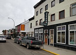 The Jasper Hotel on Jasper Street | |
| Motto: "Where Past Is Present" | |
 Maple Creek  Maple Creek | |
| Coordinates: 49°54′21″N 109°28′46″W / 49.90583°N 109.47944°W | |
| Country | Canada |
| Province | Saskatchewan |
| Rural municipality | Maple Creek |
| Established | 1882 |
| Incorporated (village) | 1896 |
| Incorporated (town) | April 30, 1903 |
| Government | |
| • Mayor | Michelle McKenzie |
| • Town Manager | Barry Elliott, CAO |
| • Governing body | Maple Creek Town Council |
| • MP | Jeremy Patzer |
| • MLA | Doug Steele |
| Area | |
| • Land | 4.42 km2 (1.71 sq mi) |
| Population (2016)[1] | |
| • Total | 2,084 |
| • Density | 471.3/km2 (1,221/sq mi) |
| Time zone | CST |
| Postal code | S0N 1N0 |
| Area code | 306 |
| Highways | Highway 21 Highway 271 Highway 724 |
| Railways | Canadian Pacific |
| Climate | Dfb |
| Website | maplecreek.ca |
| [2][3] | |
The town is 103 kilometres (64 mi) southeast of Medicine Hat, Alberta, and 40 kilometres (25 mi) north of the Cypress Hills Interprovincial Park on Highway 21 and 8 kilometres (5.0 mi) south of the Trans-Canada Highway. Maple Creek runs along the west side of town.
The administrative headquarters of the Nekaneet Cree Nation is 37 km (23 mi) southeast of Maple Creek.[4]
History edit

After the North-West Mounted Police had been established at Fort Walsh, settlers began to explore the Cypress Hills area, living along the creeks and doing small-scale ranching. The Department of the Interior was operating a First Nations farm on the Maple Creek, a few miles south from the present town site. In 1882-1883 the First Nations (mainly Cree, Saulteaux, and Assiniboine) were moved to Qu'Appelle, and the farm was then operated by Major Shurtleff, an ex-Mounted Policeman, and George Wood, his brother-in-law.
In the winter of 1882, a Canadian Pacific Railway construction crew of 12 decided to winter where the town of Maple Creek now stands. This marked the establishment of Maple Creek.[5]
In June 2010, a flood submerged some of the town when Maple Creek overflowed its banks. The same flood hit much of southwestern Saskatchewan and southern Alberta and even destroyed a portion of the Trans-Canada Highway.[6]
Heritage sites edit
There are two designated municipal heritage Properties in Maple Creek:
- The W. R. Orr Heritage Building was constructed in 1910 and over its history it has housed the Union Bank of Canada; W.R. Orr Law Office; Royal Bank of Canada; Bank of Montreal; Burnett & Orr Law Office.[7]
- The St. Mary's Anglican Church was constructed in 1909 in the Romanesque style. The church also contains a vestry, narthex, and octagonal belfry with steeple that was added in 1928.[8]
Demographics edit
| Year | Pop. | ±% |
|---|---|---|
| 1901 | 382 | — |
| 1906 | 687 | +79.8% |
| 1911 | 936 | +36.2% |
| 1916 | 1,140 | +21.8% |
| 1921 | 1,002 | −12.1% |
| 1926 | 930 | −7.2% |
| 1931 | 1,154 | +24.1% |
| 1936 | 1,032 | −10.6% |
| 1941 | 1,085 | +5.1% |
| 1946 | 1,280 | +18.0% |
| 1951 | 1,638 | +28.0% |
| 1956 | 1,974 | +20.5% |
| 1961 | 2,291 | +16.1% |
| 1966 | 2,359 | +3.0% |
| 1971 | 2,268 | −3.9% |
| 1976 | 2,330 | +2.7% |
| 1981 | 2,470 | +6.0% |
| 1986 | 2,452 | −0.7% |
| 1991 | 2,334 | −4.8% |
| 1996 | 2,307 | −1.2% |
| 2001 | 2,270 | −1.6% |
| 2006 | 2,198 | −3.2% |
| 2011 | 2,176 | −1.0% |
| 2016 | 2,084 | −4.2% |
| 2021 | 2,176 | +4.4% |
| Source: Statistics Canada [9][10][11][12][13][14][15][16][1] | ||
In the 2021 Census of Population conducted by Statistics Canada, Maple Creek had a population of 2,176 living in 988 of its 1,083 total private dwellings, a change of 4.4% from its 2016 population of 2,084. With a land area of 4.35 km2 (1.68 sq mi), it had a population density of 500.2/km2 (1,295.6/sq mi) in 2021.[17]
| 2021 | 2016 | 2011 | |
|---|---|---|---|
| Population | 2,176 (+4.4% from 2016) | 2,084 (-4.2% from 2011) | 2,176 (-1.0% from 2006) |
| Land area | 4.35 km2 (1.68 sq mi) | 4.42 km2 (1.71 sq mi) | 4.42 km2 (1.71 sq mi) |
| Population density | 500/km2 (1,300/sq mi) | 471.3/km2 (1,221/sq mi) | 492.1/km2 (1,275/sq mi) |
| Median age | 46.8 (M: 45.2, F: 48.0) | 46.5 (M: 46.4, F: 46.6) | |
| Private dwellings | 1,083 (total) 988 (occupied) | 1,070 (total) | 1,028 (total) |
| Median household income | $65,500 |
| Population by ethnic origin, 2011 | ||
|---|---|---|
| Ethnic group[23] | Population | Percent |
| European | 1,780 | 81.8% |
| Other North American | 630 | 29% |
| First Nations | 140 | 6.4% |
| Métis | 50 | 2.3% |
| African | 25 | 1.1% |
| Latin, Central and South American | 20 | 0.9% |
| Asian | 15 | 0.7% |
| Total respondent population | 2175 | 100% |
Climate edit
Maple Creek experiences a semi-arid climate (Köppen climate classification BSk). With the exception of southwestern Alberta, winters in Maple Creek are typically warmer than those in the adjacent plain region of southern Alberta and Saskatchewan, being a convergence point for Chinook winds originating along the Rocky Mountain Front. The mean maximum temperature in January 2006 was 5.3 °C [1] for the Maple Creek townsite, compared to 5.0 °C [2] for Calgary and 4.7 °C [3] for Medicine Hat.
The highest temperature ever recorded in Maple Creek was 41.0 °C (106 °F) on 29 June 1984.[24] The coldest temperature ever recorded was −46.7 °C (−52 °F) on 15 & 16 February 1936.[25]
| Climate data for Maple Creek, 1981–2010 normals, extremes 1921–present[a] | |||||||||||||
|---|---|---|---|---|---|---|---|---|---|---|---|---|---|
| Month | Jan | Feb | Mar | Apr | May | Jun | Jul | Aug | Sep | Oct | Nov | Dec | Year |
| Record high °C (°F) | 21.1 (70.0) |
19.5 (67.1) |
24.0 (75.2) |
33.3 (91.9) |
37.8 (100.0) |
41.0 (105.8) |
40.6 (105.1) |
40.6 (105.1) |
37.8 (100.0) |
33.3 (91.9) |
24.0 (75.2) |
21.7 (71.1) |
41.0 (105.8) |
| Mean daily maximum °C (°F) | −2.8 (27.0) |
−0.1 (31.8) |
5.6 (42.1) |
13.4 (56.1) |
18.9 (66.0) |
23.1 (73.6) |
27.7 (81.9) |
27.1 (80.8) |
20.2 (68.4) |
13.1 (55.6) |
3.4 (38.1) |
−1.7 (28.9) |
12.3 (54.1) |
| Daily mean °C (°F) | −8.5 (16.7) |
−5.8 (21.6) |
−0.2 (31.6) |
6.5 (43.7) |
11.7 (53.1) |
16.1 (61.0) |
19.9 (67.8) |
19.2 (66.6) |
13.0 (55.4) |
6.6 (43.9) |
−2.0 (28.4) |
−7.1 (19.2) |
5.8 (42.4) |
| Mean daily minimum °C (°F) | −14.0 (6.8) |
−11.4 (11.5) |
−6.0 (21.2) |
−0.5 (31.1) |
4.5 (40.1) |
9.0 (48.2) |
12.0 (53.6) |
11.2 (52.2) |
5.7 (42.3) |
0.0 (32.0) |
−7.2 (19.0) |
−12.5 (9.5) |
−0.8 (30.6) |
| Record low °C (°F) | −45.6 (−50.1) |
−46.7 (−52.1) |
−36.1 (−33.0) |
−23.3 (−9.9) |
−12.2 (10.0) |
−3.3 (26.1) |
1.0 (33.8) |
−0.6 (30.9) |
−12.8 (9.0) |
−25.0 (−13.0) |
−34.0 (−29.2) |
−42.8 (−45.0) |
−46.7 (−52.1) |
| Average precipitation mm (inches) | 18.1 (0.71) |
13.1 (0.52) |
22.2 (0.87) |
25.0 (0.98) |
47.1 (1.85) |
76.5 (3.01) |
45.9 (1.81) |
43.4 (1.71) |
36.3 (1.43) |
23.9 (0.94) |
19.0 (0.75) |
17.6 (0.69) |
388.1 (15.28) |
| Average rainfall mm (inches) | 1.4 (0.06) |
0.7 (0.03) |
5.7 (0.22) |
18.4 (0.72) |
41.8 (1.65) |
76.5 (3.01) |
45.9 (1.81) |
43.0 (1.69) |
34.9 (1.37) |
16.0 (0.63) |
2.6 (0.10) |
0.9 (0.04) |
287.6 (11.32) |
| Average snowfall cm (inches) | 16.7 (6.6) |
12.3 (4.8) |
16.6 (6.5) |
6.6 (2.6) |
5.4 (2.1) |
0.0 (0.0) |
0.0 (0.0) |
0.4 (0.2) |
1.5 (0.6) |
7.9 (3.1) |
16.4 (6.5) |
16.7 (6.6) |
100.5 (39.6) |
| Source: Environment Canada[24][26][27] | |||||||||||||
- ^ Extreme high and low temperatures in the table below were recorded at Maple Creek from July 1921 to June 1967, at Maple Creek North from July 1967 to November 2007 and at Maple Creek from December 2007 to present.
Attractions edit
- Cypress Hills Interprovincial Park, an interprovincial park straddling the southern Alberta-Saskatchewan border, north-west of Robsart.
- Cypress Hills Vineyard & Winery[28]
- Fort Walsh, a reconstructed North-West Mounted Police fort and part of the Cypress Hills Interprovincial Park. As a National Historic Site of Canada the area possesses national historical significance. It was established as a NWMP fort after and near the Cypress Hills Massacre.
- Grasslands National Park, represents the Prairie Grasslands natural region, protecting one of the nation's few remaining areas of undisturbed dry mixed-grass/shortgrass prairie grassland. The park is in the WWF-defined Northern short grasslands ecoregion, which spans across much of Southern Saskatchewan, Southern Alberta, and the northern Great Plains states in the USA. The unique landscape and harsh, semi-arid climate provide niches for several specially adapted plants and animals. The park and surrounding area house the country's only black-tailed prairie dog colonies. Other rare and endangered fauna in the park include the pronghorn, sage grouse, burrowing owl, ferruginous hawk, prairie rattlesnake, black-footed ferret and eastern short-horned lizard. Flora includes blue grama grass, needlegrass, Plains Cottonwood and silver sagebrush.
- Robsart Art Works features Saskatchewan artists featuring photographers of old buildings and towns throughout Saskatchewan.[29]
- T.rex Discovery Centre, a facility to house the fossil record of the Eastend area started many years before the discovery of "Scotty" the T.Rex in 1994.[30]
Education edit
The Sidney Street School[31] and the Maple Creek Composite School[32] serve the local community.
Great Plains College operates a satellite campus in Maple Creek.
Notable people edit
- Stuart John Cameron, MLA for Regina South
- Barry Dean, NHL player for the Philadelphia Flyers
- Dickson Delorme, YouTuber (Quick Dick McDick), farmer, comedian
- Gordon Poirier, NHL player for Montreal Canadiens
- Zack Smith, NHL player for the Chicago Blackhawks
See also edit
References edit
- ^ a b "2016 Census Profile". Statistics Canada. Government of Canada. Retrieved March 18, 2017.
- ^ National Archives, Archivia Net. "Post Offices and Postmasters". Retrieved June 1, 2014.
- ^ Government of Saskatchewan, MRD Home. "Municipal Directory System". Archived from the original on January 15, 2016. Retrieved June 1, 2014.
- ^ "Nekaneet - FHQ Tribal Council". fhqtc.com. Retrieved July 17, 2018.
- ^ "Jasper Cultural and Historical Centre – Where Your Past is Preserved". Retrieved August 15, 2022.
- ^ Pentland, R. S.; Abrahamson, B. T.; Wiens, L. H. "Maple Creek (Bigstick lake) Watershed June, 2010 Flood" (PDF). Water Resources Consultants Ltd. Government of Saskatchewan. Retrieved February 21, 2023.
- ^ http://heritageapp.cyr.gov.sk.ca/assets/pdf/2848.pdf Archived 2011-07-06 at the Wayback Machine Saskatchewan Register of Heritage Property W. R. Orr Heritage Building
- ^ http://heritageapp.cyr.gov.sk.ca/assets/pdf/124.pdf Archived 2011-07-06 at the Wayback Machine Saskatchewan Register of Heritage Property St. Mary's Anglican Church
- ^ "Table 5: Population of urban centres, 1916-1946, with guide to locations". Census of the Prairie Provinces, 1946. Vol. I: Population. Ottawa: Dominion Bureau of Statistics. 1949. pp. 397–400.
- ^ "Table 6: Population by sex, for census subdivisions, 1956 and 1951". Census of Canada, 1956. Vol. I: Population. Ottawa: Dominion Bureau of Statistics. 1958.
- ^ "Table 9: Population by census subdivisions, 1966 by sex, and 1961". 1966 Census of Canada. Western Provinces. Vol. Population: Divisions and Subdivisions. Ottawa: Dominion Bureau of Statistics. 1967.
- ^ "Table 3: Population for census divisions and subdivisions, 1971 and 1976". 1976 Census of Canada. Census Divisions and Subdivisions, Western Provinces and the Territories. Vol. Population: Geographic Distributions. Ottawa: Statistics Canada. 1977.
- ^ "Table 2: Census Subdivisions in Alphabetical Order, Showing Population Rank, Canada, 1981". 1981 Census of Canada. Vol. Census subdivisions in decreasing population order. Ottawa: Statistics Canada. 1982. ISBN 0-660-51563-6.
- ^ "Table 2: Population and Dwelling Counts, for Census Divisions and Census Subdivisions, 1986 and 1991 – 100% Data". 91 Census. Vol. Population and Dwelling Counts – Census Divisions and Census Subdivisions. Ottawa: Statistics Canada. 1992. pp. 100–108. ISBN 0-660-57115-3.
- ^ "Population and Dwelling Counts, for Canada, Provinces and Territories, and Census Divisions, 2001 and 1996 Censuses – 100% Data (Saskatchewan)". Statistics Canada. Retrieved May 25, 2019.
- ^ "Population and dwelling counts, for Canada, provinces and territories, and census subdivisions (municipalities), 2006 and 2001 censuses – 100% data (Saskatchewan)". Statistics Canada. January 6, 2010. Retrieved May 25, 2019.
- ^ "Population and dwelling counts: Canada, provinces and territories, census divisions and census subdivisions (municipalities), Saskatchewan". Statistics Canada. February 9, 2022. Retrieved April 1, 2022.
- ^ "2021 Community Profiles". 2021 Canadian Census. Statistics Canada. February 4, 2022. Retrieved October 19, 2023.
- ^ "2016 Community Profiles". 2016 Canadian Census. Statistics Canada. August 12, 2021. Retrieved March 18, 2017.
- ^ "2011 Community Profiles". 2011 Canadian Census. Statistics Canada. March 21, 2019. Retrieved August 3, 2012.
- ^ "2006 Community Profiles". 2006 Canadian Census. Statistics Canada. August 20, 2019.
- ^ "2001 Community Profiles". 2001 Canadian Census. Statistics Canada. July 18, 2021.
- ^ "NHS Profile, Maple Creek, T, Saskatchewan, 2011 (The sum of the ancestries in this table is greater than the total population estimate because a person may report more than one ancestry (ethnic origin) in the National Household Survey.)". 2011. Retrieved November 10, 2014.
- ^ a b "Maple Creek North". Canadian Climate Normals. Environment Canada. Retrieved May 2, 2016.
- ^ "Daily Data Report for February 1936". Canadian Climate Data. Environment Canada. Retrieved July 9, 2016.
- ^ "Maple Creek". Canadian Climate Data. Environment Canada. Retrieved May 2, 2016.
- ^ "Maple Creek RCS". Canadian Climate Data. Environment Canada. Retrieved May 2, 2016.
- ^ "Cypress Hills Vineyard and Winery – Taste the Prairie Sunshine!". www.cypresshillswinery.com. Retrieved July 17, 2018.
- ^ Robsart Art Works Archived 2013-06-20 at the Wayback Machine
- ^ "T.rex Discovery Centre History -". T.rex Discovery Centre History. Retrieved July 17, 2018.
- ^ "Chinook SD Schools - Sidney School". Archived from the original on November 18, 2007. Retrieved January 4, 2010.
- ^ "Chinook SD Schools - MCCHS School Website". Archived from the original on February 1, 2010. Retrieved January 4, 2010.
External links edit
![]() Media related to Maple Creek, Saskatchewan at Wikimedia Commons
Media related to Maple Creek, Saskatchewan at Wikimedia Commons