
KNOWPIA
WELCOME TO KNOWPIA

Marennes-Hiers-Brouage 
Summary
Marennes-Hiers-Brouage (French pronunciation: [maʁɛn jɛʁs bʁuaʒ]) is a commune in the Charente-Maritime department in southwestern France. It was established on 1 January 2019 by merger of the former communes of Marennes (the seat) and Hiers-Brouage.[3]
Marennes-Hiers-Brouage | |
|---|---|
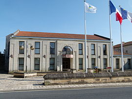 The town hall in Marennes | |
Location of Marennes-Hiers-Brouage .mw-parser-output .locmap .od{position:absolute}.mw-parser-output .locmap .id{position:absolute;line-height:0}.mw-parser-output .locmap .l0{font-size:0;position:absolute}.mw-parser-output .locmap .pv{line-height:110%;position:absolute;text-align:center}.mw-parser-output .locmap .pl{line-height:110%;position:absolute;top:-0.75em;text-align:right}.mw-parser-output .locmap .pr{line-height:110%;position:absolute;top:-0.75em;text-align:left}.mw-parser-output .locmap .pv>div{display:inline;padding:1px}.mw-parser-output .locmap .pl>div{display:inline;padding:1px;float:right}.mw-parser-output .locmap .pr>div{display:inline;padding:1px;float:left}html.skin-theme-clientpref-night .mw-parser-output .od,html.skin-theme-clientpref-night .mw-parser-output .od .pv>div,html.skin-theme-clientpref-night .mw-parser-output .od .pl>div,html.skin-theme-clientpref-night .mw-parser-output .od .pr>div{background:#000;color:#fff}html.skin-theme-clientpref-night .mw-parser-output .locmap{filter:grayscale(0.6)}@media(prefers-color-scheme:dark){html.skin-theme-clientpref-os .mw-parser-output .locmap{filter:grayscale(0.6)}html.skin-theme-clientpref-os .mw-parser-output .od,html.skin-theme-clientpref-os .mw-parser-output .od .pv>div,html.skin-theme-clientpref-os .mw-parser-output .od .pl>div,html.skin-theme-clientpref-os .mw-parser-output .od .pr>div{background:#000;color:#fff}}  Marennes-Hiers-Brouage  Marennes-Hiers-Brouage | |
| Coordinates: 45°49′21″N 1°06′19″W / 45.8225°N 1.1052°W | |
| Country | France |
| Region | Nouvelle-Aquitaine |
| Department | Charente-Maritime |
| Arrondissement | Rochefort |
| Canton | Marennes |
| Intercommunality | Bassin de Marennes |
| Government | |
| • Mayor (2020–2026) | Claude Balloteau[1] |
| Area 1 | 51.44 km2 (19.86 sq mi) |
| Population (2021)[2] | 6,175 |
| • Density | 120/km2 (310/sq mi) |
| Time zone | UTC+01:00 (CET) |
| • Summer (DST) | UTC+02:00 (CEST) |
| INSEE/Postal code | 17219 /17320 |
| Elevation | 0–21 m (0–69 ft) |
| 1 French Land Register data, which excludes lakes, ponds, glaciers > 1 km2 (0.386 sq mi or 247 acres) and river estuaries. | |
Population edit
| Year | Pop. | ±% p.a. |
|---|---|---|
| 1968 | 4,962 | — |
| 1975 | 4,654 | −0.91% |
| 1982 | 5,025 | +1.10% |
| 1990 | 5,132 | +0.26% |
| 1999 | 5,157 | +0.05% |
| 2007 | 5,948 | +1.80% |
| 2012 | 6,264 | +1.04% |
| 2017 | 6,252 | −0.04% |
| Source: INSEE[4] | ||
See also edit
References edit
- ^ "Répertoire national des élus: les maires" (in French). data.gouv.fr, Plateforme ouverte des données publiques françaises. 13 September 2022.
- ^ "Populations légales 2021". The National Institute of Statistics and Economic Studies. 28 December 2023.
- ^ Arrêté préfectoral 27 November 2018 (in French)
- ^ Population en historique depuis 1968, INSEE
External links edit
 Media related to Marennes-Hiers-Brouage at Wikimedia Commons