


-
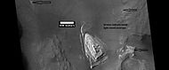
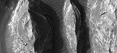
 "Homestake" formation

KNOWPIA
WELCOME TO KNOWPIA
Margaritifer Sinus quadrangle 
Summary
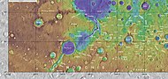
The Margaritifer Sinus quadrangle is one of a series of 30 quadrangle maps of Mars used by the United States Geological Survey (USGS) Astrogeology Research Program. The Margaritifer Sinus quadrangle is also referred to as MC-19 (Mars Chart-19).[1] The Margaritifer Sinus quadrangle covers the area from 0° to 45° west longitude and 0° to 30° south latitude on Mars. Margaritifer Sinus quadrangle contains Margaritifer Terra and parts of Xanthe Terra, Noachis Terra, Arabia Terra, and Meridiani Planum.
 Map of Margartifer Sinus quadrangle from Mars Orbiter Laser Altimeter (MOLA) data. The highest elevations are red and the lowest are blue. | |
| Coordinates | 15°00′S 22°30′W / 15°S 22.5°W |
|---|---|

The name of this quadrangle means "pearl bay" after the pearl coast at Cape Comorin in South India.[2]
This quadrangle shows many signs of past water with evidence of lakes, deltas, ancient rivers, inverted channels, and chaos regions that released water.[3] Margaritifer Sinus contains some of the longest lake-chain systems on Mars, perhaps because of a wetter climate, more groundwater, or some of each factor. The Samara/Himera lake-chain system is about 1800 km long; the Parara/Loire valley network and lake-chain system is about 1100 km long.[4] A low area between Parana Valles and Loire Vallis is believed to have once held a lake.[5][6] The 154 km diameter Holden Crater also once held a lake.[7] Near Holden Crater is a graben, called Erythraea Fossa, that once held a chain of three lakes.[8]
This region contains abundant clay-bearing sediments of Noachian age. Spectral studies with CRISM showed Fe/Mg-phyllosilicates, a type of clay. Biological materials can be preserved in clay. It is believed that this clay was formed in near-neutral pH water. The clay was not mixed with sulfates which form under acid conditions. Life is probably more likely to form under neutral pH conditions.[9]
This region of Mars is famous because the Opportunity Rover landed there on January 25, 2004, at 1.94°S and 354.47°E (5.53° W). NASA declared the mission over in a press conference on February 13, 2019. This mission lasted almost 15 years.[10] Russia's Mars 6 crash-landed in Margaritifer Sinus quadrangle at 23.9 S and 19.42 W.
Images edit
-
 Opportunity Rover as seen by HiRISE on January 29, 2009. Opportunity is on its way to Endeavour Crater, 17 km away at this point (2.1° S and 354.5° E).
 -
 Location of Opportunity Rover on surface of Mars
 -
 Mars Global Surveyor orbiter's photograph of landing site showing "hole in one"

Rock and mineral discoveries at Meridiani Planum edit


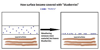
Opportunity Rover found that the soil at Meridiani Planum was very similar to the soil at Gusev crater and Ares Vallis; however in many places at Meridiani the soil was covered with round, hard, gray spherules that were named "blueberries".[11] These blueberries were found to be composed almost entirely of the mineral hematite. It was decided that the spectra signal spotted from orbit by Mars Odyssey was produced by these spherules. After further study it was decided that the blueberries were concretions formed in the ground by water.[12] Over time, these concretions weathered from what was overlying rock, and then became concentrated on the surface as a lag deposit. The concentration of spherules in bedrock could have produced the observed blueberry covering from the weathering of as little as one meter of rock.[13][14] Most of the soil consisted of olivine basalt sands that did not come from the local rocks. The sand may have been transported from somewhere else.[15]
-
 Drawing showing how "blueberries" came to cover much of surface in Meridiani Planum
Minerals in dust edit
A Mössbauer spectrum was made of the dust that gathered on Opportunity's capture magnet. The results suggested that the magnetic component of the dust was titanomagnetite, rather than just plain magnetite, as was once thought. A small amount of olivine was also detected which was interpreted as indicating a long arid period on the planet. On the other hand, a small amount of hematite that was present meant that there may have been liquid water for a short time in the early history of the planet.[16] Because the Rock Abrasion Tool (RAT) found it easy to grind into the bedrocks, it is thought that the rocks are much softer than the rocks at Gusev crater.
Bedrock minerals edit
Few rocks were visible on the surface where Opportunity landed, but bedrock that was exposed in craters was examined by the suit of instruments on the Rover.[17] Bedrock rocks were found to be sedimentary rocks with a high concentration of sulfur in the form of calcium and magnesium sulfates. Some of the sulfates that may be present in bedrocks are kieserite, sulfate anhydrate, bassanite, hexahydrite, epsomite, and gypsum. Salts, such as halite, bischofite, antarcticite, bloedite, vanthoffite, or glauberite, may also be present.[18][19]
The rocks containing the sulfates had a light tone compared to isolated rocks and rocks examined by landers/rovers at other locations on Mars. The spectra of these light toned rocks, containing hydrated sulfates, were similar to spectra taken by the Thermal Emission Spectrometer on board the Mars Global Surveyor. The same spectrum is found over a large area, so it is believed that water once appeared over a wide region, not just in the area explored by Opportunity Rover.[20]
The Alpha Particle X-ray Spectrometer (APXS) found rather high levels of phosphorus in the rocks. Similar high levels were found by other rovers at Ares Vallis and Gusev Crater, so it has been hypothesized that the mantle of Mars may be phosphorus-rich.[21] The minerals in the rocks could have originated by acid weathering of basalt. Because the solubility of phosphorus is related to the solubility of uranium, thorium, and rare earth elements, they are all also expected to be enriched in rocks.[22]
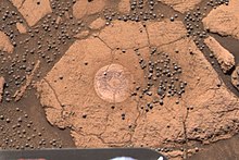
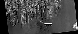
When Opportunity Rover traveled to the rim of Endeavour crater, it soon found a white vein that was later identified as being pure gypsum.[23][24] It was formed when water carrying gypsum in solution deposited the mineral in a crack in the rock. A picture of this vein, called "Homestake" formation, is shown below.

Evidence for water edit

Examination of Meridiani rocks found strong evidence for past water. The mineral called jarosite which only forms in water was found in all bedrocks. This discovery proved that water once existed in Meridiani Planum[25] In addition, some rocks showed small laminations (layers) with shapes that are only made by gently flowing water.[26] The first such laminations were found in a rock called "The Dells". Geologists would say that the cross-stratification showed festoon geometry from transport in subaqueous ripples.[19] A picture of cross-stratification, also called cross-bedding, is shown on the left.
Box-shaped holes in some rocks were caused by sulfates forming large crystals, and then when the crystals later dissolved, holes, called vugs, were left behind.[26] The concentration of the element bromine in rocks was highly variable probably because it is very soluble. Water may have concentrated it in places before it evaporated. Another mechanism for concentrating highly soluble bromine compounds is frost deposition at night that would form very thin films of water that would concentrate bromine in certain spots.[11]
-
 Voids or "vugs" inside the rock

Rock from impact edit
One rock, "Bounce Rock", found sitting on the sandy plains was found to be ejecta from an impact crater. Its chemistry was different from the bedrocks. Containing mostly pyroxene and plagioclase and no olivine, it closely resembled a part, Lithology B, of the shergottite meteorite EETA 79001, a meteorite known to have come from Mars. Bounce rock received its name by being near an airbag bounce mark.[13]
Meteorites edit
Opportunity Rover found meteorites just sitting on the plains. The first one analyzed with Opportunity's instruments was called "Heatshield Rock", as it was found near where Opportunity's headshield landed. Examination with the Miniature Thermal Emission Spectrometer (Mini-TES), Mossbauer spectrometer, and APXS lead researchers to, classify it as an IAB meteorite. The APXS determined it was composed of 93% iron and 7% nickel. The cobble named "Fig Tree Barberton" is thought to be a stony or stony-iron meteorite (mesosiderite silicate),[27][28] while "Allan Hills", and "Zhong Shan" may be iron meteorites.
-
 Heat Shield Rock was the first meteorite ever identified on another planet.
 -
 Heat shield, with Heat Shield Rock just above and to the left in the background


Geological history edit
Observations at the site have led scientists to believe that the area was flooded with water a number of times and was subjected to evaporation and desiccation.[13] In the process sulfates were deposited. After sulfates cemented the sediments, hematite concretions grew by precipitation from groundwater. Some sulfates formed into large crystals which later dissolved to leave vugs. Several lines of evidence point toward an arid climate in the past billion years or so, but a climate supporting water, at least for a time, in the distant past.[29][30]
Vallis edit
Vallis (plural valles) is the Latin word for "valley". It is used in planetary geology for the naming of valley landform features on other planets.
Vallis was used for old river valleys that were discovered on Mars, when probes were first sent to Mars. The Viking Orbiters caused a revolution in our ideas about water on Mars; huge river valleys were found in many areas. Space craft cameras showed that floods of water broke through dams, carved deep valleys, eroded grooves into bedrock, and traveled thousands of kilometers.[31][32][33] Nirgal Vallis is a tributary of Uzboi Vallis. Nirgal Vallis is believed to have formed by groundwater sapping, not by precipitation. Spectral analyses has found phyllosilicates (clays) that are iron-magnesium smectites.[34][35] Some researchers believe these were formed by interaction with groundwater. Over a wide area, Al-smectites are found on top of Fe/Mg smectites.[36]
-
 Map showing locations of several valleys in the Margaritifer Sinus quadrangle: Landon Valles, Nirgal Vallis, Uzboi Vallis, Arda Valles, Samara Valles, Himera Valles, and Clota Vallis

-
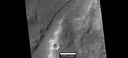
 Parana Valles, as seen by HiRISE. Scale bar is 1000 meters long.
 -
 Ladon Valles, as seen by HiRISE. Click on image to see dark and light-toned layers.
 -
 Tear-drop shaped islands caused by flood waters from Maja Vallis, as seen by Viking Orbiter. Image is located in Oxia Palus quadrangle.
 -
 The long channel Nirgal Vallis is shown where it connects to Uzboi Vallis. The crater Luki is 21 km in diameter. Picture taken by THEMIS.
 -
 Nirgal Vallis, as seen by THEMIS
 -
 Nirgal Vallis close-up, as seen by THEMIS
 -
 Channel that enters Kasimov Crater, as seen by HiRISE under HiWish program


Branched streams seen by Viking edit
The Viking orbiters discovered much about water on Mars. Branched streams, studied by the orbiters in the southern hemisphere, suggested that rain once fell.[31][32][33]
-
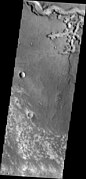
 The branched channels seen by Viking from orbit strongly suggested that it rained on Mars in the past. Image is located in Margaritifer Sinus quadrangle.

Aureum Chaos edit
Aureum Chaos is a major canyon system and collapsed area. It is probably a major source of water for large outflow channels.
Large outflow channels on Mars are believed to be caused by catastrophic discharges of ground water. Many of the channels begin in chaotic terrain, where the ground has apparently collapsed. In the collapsed section, blocks of undisturbed material be seen. The OMEGA experiment on Mars Express discovered clay minerals (phyllosilicates) in a variety of places in Aureum Chaos. Clay minerals need water to form, so the area may once have contained large amounts of water.[37] Scientists are interested in determining what parts of Mars contained water because evidence of past or present life may be found there.
-
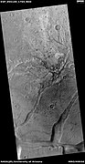
 Huge canyons in Aureum Chaos. Gullies are rare at this latitude. Picture taken by THEMIS.
 -
 Aureum Chaos, as seen from THEMIS
 -
 View of Aureum Chaos, as seen by HiRISE
 -
 Layered butte in Aureum Chaos, as seen by HiRISE
 -
 Light toned butte on floor of crater, as seen by HiRISE. Arrows show outcrops of light toned material. Light toned material is probably sulfate-rich and similar to material examined by Spirit Rover, and it once probably covered the whole floor. Other images below show enlargements of the butte.
 -
 Enlargement of white butte, as seen by HiRISE. Box shows size of a football field.
 -
 Closer view towards top of white butte, as seen by HiRISE. Box shows size of a football field.
 -
 Top of white butte, as seen by HiRISE. Box shows size of a football field.


-
 Light-toned mass in Aureum Chaos, as seen by HiRISE. Light-toned materials often form on Mars with the aid of water.
 -
 Layered features, as seen by HiRISE. Light-toned materials often form on Mars with the aid of water. Gray material in image is probably dark, basalt sand.
 -
 Layered features, as seen by HiRISE. Light-toned materials often form on Mars with the aid of water. Gray material in image is probably dark, basalt sand.
 -
 Light and dark layers, as seen by HiRISE


On April 1, 2010, NASA released the first images under the HiWish program, with the public suggesting places for HiRISE to photograph. One of the eight locations was Aureum Chaos.[38] The first image below gives a wide view of the area. The next two images are from the HiRISE image.[39]
-
 THEMIS image of wide view of following HiRISE images. Black box shows approximate location of HiRISE images. This image is just a part of the vast area known as Aureum Chaos.
 -
 Aureum Chaos, as seen by HiRISE
 -
 Close up view of previous image, as seen by HiRISE. Small round dots are boulders.


Layers edit
Many places on Mars show rocks arranged in layers. Rock can form layers in a variety of ways. Volcanoes, wind, or water can produce layers.[40] A detailed discussion of layering with many Martian examples can be found in Sedimentary Geology of Mars.[41] Sometimes the layers are of different colors. Light-toned rocks on Mars have been associated with hydrated minerals like sulfates.[42][43][44][45] The Mars rover Opportunity examined such layers close up with several instruments. Some layers are probably made up of fine particles because they seem to break up into find dust. Other layers break up into large boulders so they are probably much harder. Basalt, a volcanic rock, is thought to in the layers that form boulders. Basalt has been identified on Mars in many places. Instruments on orbiting spacecraft have detected clay (also called phyllosilicate) in some layers.
A detailed discussion of layering with many Martian examples can be found in Sedimentary Geology of Mars.[41]
Layers can be hardened by the action of groundwater. Martian ground water probably moved hundreds of kilometers, and in the process it dissolved many minerals from the rock it passed through. When ground water surfaces in low areas containing sediments, water evaporates in the thin atmosphere and leaves behind minerals as deposits and/or cementing agents. Consequently, layers of dust could not later easily erode away since they were cemented together.
,
-
 Light and dark layers, as seen by HiRISE. This is a wide view and layers can not be seen well, but a set of light layers can be seen just beneath the scale bar.
 -
 Light-toned layers with patches of dark sand from the same region as previous image. Picture taken with HiRISE.
 -
 Dark-toned layers shown with white arrows, as seen by HiRISE. This is in same region as previous two images.
 -
 Layers exposed in a pit in Lotto crater, as seen by HiRISE. The light-toned layers may contain sulfates which are good for preserving traces of ancient life.
 -
 Enlargement of previous image of layers, as seen by HiRISE
 -
 Close up of a previous image of layers in Lotto Crater, as seen by HiRISE
 -
 Layers, as seen by HiRISE
 -
 Wide view of layers in wall of Aurorae Chaos, as seen by HiRISE
 -
 Close view of layers from previous image, as seen by HiRISE
 -
 Close view of layers from a previous image, as seen by HiRISE. Box shows the size of football field.
 -
 Close view of layers from a previous image, as seen by HiRISE
 -
 Layers, as seen by HiRISE


-
 Wide view of layers and light-toned material, as seen by HiRISE
 -
 Close view of layers and light-toned material, as seen by HiRISE
 -
 Close view of layers and light-toned material, as seen by HiRISE
 -
 Light-toned material, as seen by HiRISE
 -
 Narrow ridge, as seen by HiRISE
 -
 Section of ridge that has eroded, as seen by HiRISE
 -
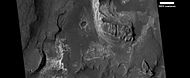
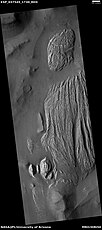
 Layers in mesas, as seen by HiRISE
 -
 Close view of layers, as seen by HiRISE
 -
 Close view of layers, as seen by HiRISE
 -
 Layers in mounds, as seen by HiRISE under HiWish program


Mars Science Laboratory edit
Several sites in the Margaritifer Sinus quadrangle have been proposed as areas to send NASA's next major Mars rover, the Mars Science Laboratory. Both Holden crater and Eberswalde crater made the cut to be among the top four.[46] Miyamoto Crater was in the top seven sites chosen. Holden crater is believed to have once been a lake. Actually, it is now believed that it held two lakes.[47] The first was longer lived and was formed from drainage within the crater and precipitation. The last lake began when water dammed up in Uzboi Vallis broke through a divide, then rapidly drained into Holden crater. Because there are rocks meters in diameter on the crater floor, it is thought it was a powerful flood when water flowed into the crater.[7]
-
 West Rim of Holden crater, as seen by THEMIS
 -
 Close-up of channels on rim of Holden crater, as seen by THEMIS


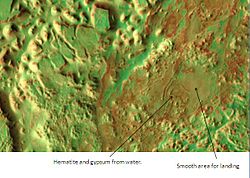
Eberswalde Crater contains a delta.[48] There is a great deal of evidence that Miyamoto crater once contained rivers and lakes. Many minerals, such as clays, chlorides, sulfates, and iron oxides, have been discovered there.[49] These minerals are often formed in water. A picture below shows an inverted channel in Miyamoto crater. Inverted channels formed from accumulated sediments that were cemented by minerals. These channels eroded into the surface, then the whole area was covered over with sediments. When the sediments were later eroded away, the place where the river channel existed remained because the hardened material that was deposited in the channel was resistant to erosion.[50] Iani Chaos, pictured below, was among the top 33 landing sites. Deposits of hematite and gypsum have been found there.[51] Those minerals are usually formed in connection with water.
-
 Iani Chaos, as seen by THEMIS. Sand from eroding mesas is covering brighter floor material.
 -
 Landing zone in Iani Chaos, as seen by THEMIS


The aim of the Mars Science Laboratory is to search for signs of ancient life. It is hoped that a later mission could then return samples from sites that the Mars Science Laboratory identified as probably containing remains of life. To safely bring the craft down, a 12-mile-wide, smooth, flat circle is needed. Geologists hope to examine places where water once ponded.[51] They would like to examine sediment layers. In the end, it was decided to send the Mars science Laboratory, called "Curiosity", to Gale crater in the Aeolis quadrangle.
Inverted relief edit
Some places on Mars show inverted relief. In these locations, a stream bed may be a raised feature, instead of a valley. The inverted former stream channels may be caused by the deposition of large rocks or due to cementation. In either case erosion would erode the surrounding land and leave the old channel as a raised ridge because the ridge will be more resistant to erosion. An image below, taken with HiRISE of Miyamoto crater shows a ridge that is an old channel that has become inverted.[52]
-
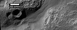
 Inverted channel in Miyamoto crater, as seen by HiRISE. The scale bar is 500 meters long.
 -
 CTX context image for next image that was taken with HiRISE. Note long ridge going across image is probably an old stream. Box indicates area for HiRISE image.
 -
 Example of inverted terrain in Parana Valles region, as seen by HiRISE


Deltas edit
Researchers have found a number of examples of deltas that formed in Martian lakes. Finding deltas is a major sign that Mars once had a lot of water. Deltas often require deep water over a long period of time to form. Also, the water level needs to be stable to keep sediment from washing away. Deltas have been found over a wide geographical range.[53]
-
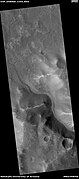
 Delta in Margaritifer Sinus quadrangle as seen by THEMIS
 -
 Probable delta in Eberswalde crater that lies to the NE of Holden crater, as seen by Mars Global Surveyor. Image in Margaritifer Sinus quadrangle.
 -
 Wide view of a delta in Holden crater, as seen by CTX
 -
 Close up view of part of delta from previous image, as seen by HiRISE
 -
 Close view of previous image showing layers


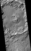
Craters edit
Impact craters generally have a rim with ejecta around them, in contrast volcanic craters usually do not have a rim or ejecta deposits. As craters get larger (greater than 10 km in diameter) they usually have a central peak.[54] The peak is caused by a rebound of the crater floor following the impact.[31] Sometimes craters will display layers. Craters can show us what lies deep under the surface.
In December 2011, Opportunity Rover discovered a vein of gypsum sticking out of the soil along the rim of Endeavour crater. Tests confirmed that it contained calcium, sulfur, and water. The mineral gypsum is the best match for the data. It likely formed from mineral rich water moving through a crack in the rock. The vein, called "Homestake", is in Mars' Meridiani plain. It could have been produced in conditions more neutral than the harshly acidic conditions indicated by the other sulfate deposits; hence this environment may have been more hospitable for a large variety of living organisms. Homestake is in a zone where the sulfate-rich sedimentary bedrock of the plains meets older, volcanic bedrock exposed at the rim of Endeavour crater.[55]
-
 Beer Crater eroded west wall, as seen by CTX
 -
 Alga Crater, as seen by HiRISE. Click on image to see the relationship between Alga Crater and the larger Chekalin Crater.
 -
 Timbuktu Crater, located on the edge of Capri Chasma. Image taken with THEMIS.
 -
 Vinogradov Crater, as seen by CTX camera (on Mars Reconnaissance Orbiter)
 -
 Fans on crater floor on the rim of Vinogradov Crater, as seen by CTX camera (on Mars Reconnaissance Orbiter). Note: this is an enlargement of the top part of the previous image of Vinogradov Crater.
 -
 Jones Crater, as seen by CTX camera (on Mars Reconnaissance Orbiter). Regions on the floor containing layers, fans, and dunes are labeled.
 -
 Double crater, as seen by HiRISE under HiWish program The impactor may have broke apart right before striking the surface.


Unnamed channels edit
There is enormous evidence that water once flowed in river valleys on Mars.[56][57] Images of curved channels have been seen in images from Mars spacecraft dating back to the early 1970s with the Mariner 9 orbiter.[58][59][60][61] Indeed, a study published in June 2017, calculated that the volume of water needed to carve all the channels on Mars was even larger than the proposed ocean that the planet may have had. Water was probably recycled many times from the ocean to rainfall around Mars.[62][63]
-
 Group of channels on a mound, as seen by HiRISE under HiWish program. Arrows show eroded craters.
 -
 Wide view of a group of channels, as seen by HiRISE under HiWish project. Some parts of the surface show patterned ground when enlarged.
 -
 Patterned ground, as seen by HiRISE under HiWish program. This is a close up from previous image.
 -
 Channel, as seen by HiRISE, under HiWish program
 -
 Channel just west of Uzboi Vallis, as seen by HiRISE, under HiWish program


Other landscapes edit
-
 Bedrock in Luki Crater, enhanced HiRISE color image. The central region of the crater consists of uplifted ancient bedrock with a variety of rock types, indicated by the range of colors. Image is about 1 km. wide.
 -
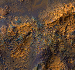
 Light-toned materials, as seen by HiRISE under HiWish program
 -
 Butte in Arsinoes Chaos with some light-toned layers, as seen by HiRISE under HiWish program
 -
 Light-toned deposit in Arsinoes Chaos, as seen by CTX camera (on Mars Reconnaissance Orbiter)
 -
 Light-toned deposit in Arsinoes Chaos, as seen by HiRISE under HiWish program. Note: this field can be found in the previous wide image of Arsinoes Chaos, as seen by CTX camera (on Mars Reconnaissance Orbiter).
 -
 Light-toned deposit in Arsinoes Chaos, as seen by HiRISE under HiWish program. These kind of deposits often contain water bearing minerals like sulfates.
 -
 Yardangs formed in light-toned material and surrounded by dark, volcanic basalt sand, as seen by HiRISE under HiWish program
 -
 Close-up image of yardangs, as seen by HiRISE under HiWish program. Arrows point to transverse aeolian ridges (TARs), a type of dune. Note this is an enlargement of the previous image from HiRISE.
 -
 Close, color view of unusual TARs, as seen by HiRISE under HiWish program. These features may have had variable local winds to make the wavy tops.
 -
 Close view of TARs with waves, as seen by HiRISE under HiWish program
 -
 Close, color view of TARs in a channel,as seen by HiRISE under HiWish program
 -
 Mesa, as seen by HiRISE under HiWish program. This may make for a good race around a mesa someday in the far future.
 -
 Ridges, as seen by HiRISE under HiWish program. This is a close up from a previous image.
 -
 Color view of surface in a previous image, as seen by HiRISE under HiWish program
 -
 Color image of patterned ground, enlarged from a previous image, as seen by HiRISE under HiWish program


Other Mars quadrangles edit

Interactive Mars map edit

(See also: Mars Rovers map and Mars Memorial map) (view • discuss)
See also edit
- Composition of Mars – Branch of the geology of Mars
- Geology of Mars – Scientific study of the surface, crust, and interior of the planet Mars
- Groundwater on Mars – Water held in permeable ground
- HiRISE – Camera on board the Mars Reconnaissance Orbiter
- Impact crater – Circular depression in a solid astronomical body formed by the impact of a smaller object
- Lakes on Mars – Overview of the presence of lakes on Mars
- List of areas of chaos terrain on Mars
- Chaos terrain – Distinctive area of broken or jumbled terrain
- Geology of Mars – Scientific study of the surface, crust, and interior of the planet Mars
- Galaxias Chaos – Chaos on Mars
- Martian chaos terrain – Irregular groups of large blocks of rock
- Martian Craters
- Martian soil – Fine regolith found on the surface of Mars
- Opportunity rover – NASA Mars rover deployed in 2004
- Outflow channels – Long, wide swathes of scoured ground on Mars
- Scientific information from the Mars Exploration Rover mission
- Spirit rover – NASA Mars rover, active from 2004 to 2010
- Uzboi-Landon-Morava (ULM) – Series of channels and depressions that may have carried water across a major part of Mars
- Vallis – Valley landform on other planets
- Water on Mars – Study of past and present water on Mars
References edit
- ^ Davies, M.E.; Batson, R.M.; Wu, S.S.C. "Geodesy and Cartography" in Kieffer, H.H.; Jakosky, B.M.; Snyder, C.W.; Matthews, M.S., Eds. Mars. University of Arizona Press: Tucson, 1992.
- ^ Blunck, J. 1982. Mars and its Satellites. Exposition Press. Smithtown, N.Y.
- ^ Grotzinger, J. and R. Milliken (eds.) 2012. Sedimentary Geology of Mars. SEPM
- ^ Fassett, C. and J. Head III. 2008. Valley network-fed, open-basin lakes on Mars: Distribution and implications for Noachian surface and subsurface hydrology. Icarus: 198. 39-56. doi:10.1016/j.icarus.2008.06.016
- ^ Goldspiel, J. and S. Squyres. 2000. Groundwater sapping and valley formation on Mars. Icarus. 89: 176-192. doi:10.1006/icar.2000.6465
- ^ Michael H. Carr (2006). The surface of Mars. Cambridge University Press. ISBN 978-0-521-87201-0. Retrieved 21 March 2011.
- ^ a b Cabrol, N. and E. Grin (eds.). 2010. Lakes on Mars. Elsevier. NY.
- ^ Buhler, P. et al. 2011. Evidence for palelakes in Erythracea Fossa, Mars: Implications for an ancient hydrological cycle. Icarus. 213: 104–115.
- ^ Thomas, R., et al. 2017. EXTENSIVE EXPOSURE OF CLAY-BEARING NOACHIAN TERRAIN IN MARGARITIFER TERRA, MARS. Lunar and Planetary Science XLVIII (2017.). 1180.pdf
- ^ "NASA's Opportunity Rover Mission on Mars Comes to End". NASA/JPL. Retrieved 18 February 2019.
- ^ a b Yen, A., et al. 2005. An integrated view of the chemistry and mineralogy of martian soils. Nature. 435.: 49-54.
- ^ Bell, J (ed.) The Martian Surface. 2008. Cambridge University Press. ISBN 978-0-521-86698-9
- ^ a b c Squyres, S. et al. 2004. The Opportunity Rover's Athena Science Investigation at Meridiani Planum, Mars. Science: 1698-1703.
- ^ Soderblom, L., et al. 2004. Soils of Eagle Crater and Meridiani Planum at the Opportunity Rover Landing Site. Science: 306. 1723-1726.
- ^ Christensen, P., et al. Mineralogy at Meridiani Planum from the Mini-TES Experiment on the Opportunity Rover. Science: 306. 1733–1739.
- ^ Goetz, W., et al. 2005. Indication of drier periods on Mars from the chemistry and mineralogy of atmospheric dust. Nature: 436.62-65.
- ^ Bell, J., et al. 2004. Pancam Multispectral Imaging Results from the Opportunity Rover at Meridiani Planum. Science: 306.1703-1708.
- ^ Christensen, P., et al. 2004 Mineralogy at Meridiani Planum from the Mini-TES Experiment on the Opportunity Rover. Science: 306. 1733-1739.
- ^ a b Squyres, S. et al. 2004. In Situ Evidence for an Ancient Aqueous Environment at Meridian Planum, Mars. Science: 306. 1709-1714.
- ^ Hynek, B. 2004. Implications for hydrologic processes on Mars from extensive bedrock outcrops throughout Terra Meridiani. Nature: 431. 156-159.
- ^ Dreibus,G. and H. Wanke. 1987. Volatiles on Earth and Marsw: a comparison. Icarus. 71:225-240
- ^ Rieder, R., et al. 2004. Chemistry of Rocks and Soils at Meridiani Planum from the Alpha Particle X-ray Spectrometer. Science. 306. 1746-1749
- ^ "NASA - NASA Mars Rover Finds Mineral Vein Deposited by Water". www.nasa.gov. Retrieved 18 February 2019.
- ^ "Durable NASA rover beginning ninth year of Mars work". ScienceDaily. Retrieved 18 February 2019.
- ^ Klingelhofer, G. et al. 2004. Jarosite and Hematite at Meridiani Planum from Opportunity's Mossbauer Spectrometer. Science: 306. 1740-1745.
- ^ a b Herkenhoff, K., et al. 2004. Evidence from Opportunity's Microscopic Imager for Water on Meridian Planum. Science: 306. 1727-1730
- ^ Squyres, S., et al. 2009. Exploration of Victoria Crater by the Mars Rover Opportunity. Science: 1058-1061.
- ^ Schroder,C., et al. 2008. J. Geophys. Res.: 113.
- ^ Clark, B. et al. Chemistry and mineralogy of outcrops at Meridiani Planum. Earth Planet. Sci. Lett. 240: 73-94.
- ^ Salvatore, M., M. Kraft1, C. Edwards, P. Christensen. 2015. Geologic History of margaitifer Basin, Mars: Evidence for a Prolonged Yet Episodic Hydrologic System. 46th Lunar and Planetary Science Conference (2015) 1463.pdf
- ^ a b c Hugh H. Kieffer (1992). Mars. University of Arizona Press. ISBN 978-0-8165-1257-7. Retrieved 7 March 2011.
- ^ a b Raeburn, P. 1998. Uncovering the Secrets of the Red Planet Mars. National Geographic Society. Washington, D.C.
- ^ a b Moore, P. et al. 1990. The Atlas of the Solar System. Mitchell Beazley Publishers, New York.
- ^ Buczkowski D. et al. 2010. LPS XLI Abstract #1458.
- ^ Buczkowski D. et al. 2013. LPS XLIV Abstract #2331.
- ^ Buczkowski, D., K. Seelos, C. Beck, S. Murchie. 2015. POTENTIAL ALTERATION BY GROUNDWATER FLOW IN NW NOACHIS TERRA: GEOMORPHIC AND MINERALOGIC EVIDENCE IN NIRGAL AND HER DESHER VALLES. 46th Lunar and Planetary Science Conference 2271.pdf
- ^ "(HiRISE image; Observation ID: PSP_0040261765)". arizona.edu. Retrieved 18 February 2019.
- ^ "HiRISE - Captioned Image Inspired by HiWish Suggestions". www.uahirise.org. Retrieved 18 February 2019.
- ^ "HiRISE - Mesas in Aureum Chaos (ESP_016869_1775)". hirise.lpl.arizona.edu. Retrieved 18 February 2019.
- ^ "HiRISE | High Resolution Imaging Science Experiment". Hirise.lpl.arizona.edu?psp_008437_1750. Retrieved 2012-08-04.
- ^ a b Grotzinger, J. and R. Milliken (eds.). 2012. Sedimentary Geology of Mars. SEPM.
- ^ Weitz, C. et al. 2017. LIGHT-TONED MATERIALS OF MELAS CHASMA: EVIDENCE FOR THEIR FORMATION ON MARS. Lunar and Planetary Science XLVIII (2017) 2794.pdf
- ^ Weitz C., et al. 2015. Icarus: 251: 291-314
- ^ Weitz, C. 2016. Journal of Geophysical Research: Planets, 2016, 121(5): 805-835.
- ^ Bishop, J., et al. 2013. What the ancient phyllosilicates at Mawrth Vallis can tell us about possible habitability on early Mars. Planetary and Space Science: 86, 130-149.
- ^ Spaceflight, JR Minkel 2010-06-15T11:47:00Z (15 June 2010). "Next Mars Rover's Landing Site Narrowed to 4 Choices". Space.com. Retrieved 18 February 2019.
{{cite web}}: CS1 maint: numeric names: authors list (link) - ^ Grant, J., et al. 2008. HiRISE imaging of impact megabreccia and sub-meter aqueous strata in Holden crater, Mars. Geology. 36: 195-198.
- ^ NASA Narrows List of Next Mars Landing Sites. Irene Klotz, 21 November 2008. (Discovery News) Archived 25 February 2009 at the Wayback Machine
- ^ Murchie, S. et al. 2009. A synthesis of Martian aqueous mineralogy after 1 Mars year of observations from the Mars Reconnaissance Orbiter. Journal of Geophysical Research: 114. doi:10.1029/2009JE003342
- ^ "HiRISE - High Resolution Imaging Science Experiment". hirise.lpl.arizona.edu. Retrieved 18 February 2019.
- ^ a b "The Floods of Iani Chaos - Mars Odyssey Mission THEMIS". themis.mars.asu.edu. Retrieved 18 February 2019.
- ^ "Sinuous Ridges Near Aeolis Mensae (HiRISE image; Observation ID: PSP_002279_1735)". arizona.edu. Retrieved 18 February 2019.
- ^ Irwin III, R. et al. 2005. An intense terminal epoch of widespread fluvial activity on early Mars: 2. Increased runoff and paleolake development. Journal of Geophysical Research: 10. E12S15[permanent dead link]
- ^ "Stones, Wind, and Ice: A Guide to Martian Impact Craters". www.lpi.usra.edu. Retrieved 18 February 2019.
- ^ "NASA - NASA Mars Rover Finds Mineral Vein Deposited by Water". www.nasa.gov. Retrieved 18 February 2019.
- ^ Baker, V., et al. 2015. Fluvial geomorphology on Earth-like planetary surfaces: a review. Geomorphology. 245, 149–182.
- ^ Carr, M. 1996. in Water on Mars. Oxford Univ. Press.
- ^ Baker, V. 1982. The Channels of Mars. Univ. of Tex. Press, Austin, TX
- ^ Baker, V., R. Strom, R., V. Gulick, J. Kargel, G. Komatsu, V. Kale. 1991. Ancient oceans, ice sheets and the hydrological cycle on Mars. Nature 352, 589–594.
- ^ Carr, M. 1979. Formation of Martian flood features by release of water from confined aquifers. J. Geophys. Res. 84, 2995–300.
- ^ Komar, P. 1979. Comparisons of the hydraulics of water flows in Martian outflow channels with flows of similar scale on Earth. Icarus 37, 156–181.
- ^ "How Much Water Was Needed to Carve Valleys on Mars? - SpaceRef". spaceref.com. 5 June 2017. Retrieved 18 February 2019.
- ^ Luo, W., et al. 2017. New Martian valley network volume estimate consistent with ancient ocean and warm and wet climate. Nature Communications 8. Article number: 15766 (2017). doi:10.1038/ncomms15766
- ^ Morton, Oliver (2002). Mapping Mars: Science, Imagination, and the Birth of a World. New York: Picador USA. p. 98. ISBN 0-312-24551-3.
- ^ "Online Atlas of Mars". Ralphaeschliman.com. Retrieved December 16, 2012.
- ^ "PIA03467: The MGS MOC Wide Angle Map of Mars". Photojournal. NASA / Jet Propulsion Laboratory. February 16, 2002. Retrieved December 16, 2012.
External links edit
Wikimedia Commons has media related to Margaritifer Sinus quadrangle.
- Walk around Spirit Rover
- Lakes on Mars - Nathalie Cabrol (SETI Talks)