
KNOWPIA
WELCOME TO KNOWPIA

Marignac-Lasclares 
Summary
Marignac-Lasclares (French pronunciation: [maʁiɲak lasklaʁ]; Occitan: Marinhac e las Claras) is a commune in the Haute-Garonne department in southwestern France.
Marignac-Lasclares | |
|---|---|
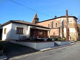 The town hall and church in Marignac-Lasclares | |
Location of Marignac-Lasclares .mw-parser-output .locmap .od{position:absolute}.mw-parser-output .locmap .id{position:absolute;line-height:0}.mw-parser-output .locmap .l0{font-size:0;position:absolute}.mw-parser-output .locmap .pv{line-height:110%;position:absolute;text-align:center}.mw-parser-output .locmap .pl{line-height:110%;position:absolute;top:-0.75em;text-align:right}.mw-parser-output .locmap .pr{line-height:110%;position:absolute;top:-0.75em;text-align:left}.mw-parser-output .locmap .pv>div{display:inline;padding:1px}.mw-parser-output .locmap .pl>div{display:inline;padding:1px;float:right}.mw-parser-output .locmap .pr>div{display:inline;padding:1px;float:left}html.skin-theme-clientpref-night .mw-parser-output .od,html.skin-theme-clientpref-night .mw-parser-output .od .pv>div,html.skin-theme-clientpref-night .mw-parser-output .od .pl>div,html.skin-theme-clientpref-night .mw-parser-output .od .pr>div{background:#000;color:#fff}html.skin-theme-clientpref-night .mw-parser-output .locmap{filter:grayscale(0.6)}@media(prefers-color-scheme:dark){html.skin-theme-clientpref-os .mw-parser-output .locmap{filter:grayscale(0.6)}html.skin-theme-clientpref-os .mw-parser-output .od,html.skin-theme-clientpref-os .mw-parser-output .od .pv>div,html.skin-theme-clientpref-os .mw-parser-output .od .pl>div,html.skin-theme-clientpref-os .mw-parser-output .od .pr>div{background:#000;color:#fff}}  Marignac-Lasclares  Marignac-Lasclares | |
| Coordinates: 43°18′25″N 1°05′57″E / 43.3069°N 1.0992°E | |
| Country | France |
| Region | Occitania |
| Department | Haute-Garonne |
| Arrondissement | Muret |
| Canton | Cazères |
| Government | |
| • Mayor (2020–2026) | Anicet Agboton[1] |
| Area 1 | 10.01 km2 (3.86 sq mi) |
| Population (2021)[2] | 475 |
| • Density | 47/km2 (120/sq mi) |
| Time zone | UTC+01:00 (CET) |
| • Summer (DST) | UTC+02:00 (CEST) |
| INSEE/Postal code | 31317 /31430 |
| Elevation | 231–310 m (758–1,017 ft) (avg. 300 m or 980 ft) |
| 1 French Land Register data, which excludes lakes, ponds, glaciers > 1 km2 (0.386 sq mi or 247 acres) and river estuaries. | |
Geography edit
The commune is bordered by four other communes: Gratens to the north, Le Fousseret to the west and southwest, Lafitte-Vigordane across the river Louge to the east, and finally by Saint-Élix-le-Château across the river Louge to the southeast.
The river Louge flows in the commune, forms a border between Lafitte-Vigordane and Saint-Élix-le-Château.
Population edit
| Year | Pop. | ±% |
|---|---|---|
| 1962 | 201 | — |
| 1968 | 235 | +16.9% |
| 1975 | 209 | −11.1% |
| 1982 | 240 | +14.8% |
| 1990 | 265 | +10.4% |
| 1999 | 295 | +11.3% |
| 2008 | 359 | +21.7% |
See also edit
References edit
- ^ "Répertoire national des élus: les maires". data.gouv.fr, Plateforme ouverte des données publiques françaises (in French). 9 August 2021.
- ^ "Populations légales 2021". The National Institute of Statistics and Economic Studies. 28 December 2023.
Wikimedia Commons has media related to Marignac-Lasclares.