


Summary
The Marikina Valley Fault System, also known as the Valley Fault System (VFS), is a dominantly right-lateral strike-slip[2] fault system in Luzon, Philippines. It extends from Doña Remedios Trinidad, Bulacan in the north and runs through the provinces of Rizal, and the Metro Manila cities of Quezon, Marikina, Pasig, Taguig and Muntinlupa, and the provinces of Cavite and Laguna that ends in Canlubang.[1]
| Marikina Valley Fault System | |
|---|---|
 Lower and upper fault plain along the West Valley Fault in Carmona, Cavite | |
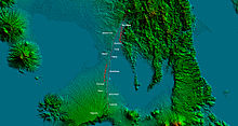
 Map of the Marikina Valley Fault System showing relative motion and deformation | |
| Etymology | Marikina |
| Named by | Philippine Institute of Volcanology and Seismology |
| Year defined | 2010 |
| Coordinates | 14°38′N 121°5′E / 14.633°N 121.083°E |
| Country | Philippines |
| Region | Central Luzon, Metro Manila, Calabarzon |
| Cities | West: Marikina, Quezon City, Pasig, Taguig, Muntinlupa, General Mariano Alvarez, Carmona, Silang, San Pedro, Biñan, Santa Rosa, Cabuyao, Calamba East: Rodriguez, San Mateo |
| Characteristics | |
| Segments | West Valley Fault, East Valley Fault |
| Length | 146 km (91 mi)[1] |
| Displacement | 10–12 mm (0.39–0.47 in)/yr |
| Tectonics | |
| Plate | Philippine Sea Plate and Sunda Plate |
| Status | Active |
| Earthquakes | 1658[citation needed], 1771[citation needed] |
| Type | Strike-slip fault |
| Movement | Dextral |
| Age | Gelasian |
| Orogeny | Luzon-Mindoro-Palawan Orogeny |
| Volcanic arc/belt | Macolod Corridor |
Fault segments edit
The fault contains two major segments, known as West Valley Fault (WVF) and East Valley Fault (EVF).
- West Valley Fault
The west segment, known as the West Valley Fault (WVF), is one of the two major fault segments of the Valley Fault System which runs through Metro Manila to the cities of Marikina, Quezon City, Pasig, Taguig and Muntinlupa[1] and moves in a dominantly dextral strike-slip motion.[2] The West Valley Fault segment traverses from Doña Remedios Trinidad to Calamba with a length of 129.47 kilometers (80.45 mi).[1]
The West Fault is capable of producing large scale earthquakes on its active phases with a magnitude of 7 or higher.[3]
- East Valley Fault
The eastern segment, known as East Valley Fault (EVF), moves in an oblique dextral motion.[2] It extends to about 17.24 kilometers (10.71 mi) from Rodriguez to San Mateo in the province of Rizal.[1]
Threat edit

Based on kinematic block models that utilize GPS, actual fault geometry, and earthquake focal mechanisms, the West segment of the Marikina Fault was resolved to be almost fully locked, meaning it is currently accumulating and loading elastic strain, at the rate of 10 to 12 mm/yr.[4] The fault possesses a threat of a large scale earthquake with an estimated magnitude between 6–7 and as high as 7.6 [5] to Metro Manila and surrounding provinces with death toll predicted to be as high as 35,000[6][7] and some 120,000 or higher[6] injured[7] and more than three million needed to be evacuated.[3]
99 private villages and subdivisions inside 80 barangays are traversed directly by the fault[8] and endangers 6,331 buildings in a span of 2,964.10 square kilometers (1,144.45 sq mi), to where majority are houses with 19 schools included in the list.[1]
References edit
- ^ a b c d e f Malicdem, Ervin (August 16, 2017). "Barangays and Buildings Traversed by the Valley Fault System". Schadow1 Expeditions. Retrieved September 7, 2017.
There are about 6,331 structures that are directly above the Valley Fault System within a 10-meter proximity which would be in potential danger of destruction once the slip-fault moves. This sums up to an area of 2,964.10 square kilometers in danger of collapse.
- ^ a b c Rimando, Rolly E.; Knuepfer, Peter L.K. (2004). "Neotectonics of the Marikina Valley fault system (MVFS) and tectonic framework of structures in northern and central Luzon, Philippines". Tectonophysics. 415 (1–4): 17–38. doi:10.1016/j.tecto.2005.11.009.
- ^ a b "'Big One' Is Possible But Metro Is Unprepared". Quezon City, Philippines: Bulatlat. August 14, 2004. Retrieved February 3, 2010.
If a major earthquake were to hit Metro Manila today, the devastation would be so big even disaster response authorities cannot simply cope with it. And it even looks like disaster preparedness occupies a low priority among officials down to the municipal level.
- ^ Galgana, Gerald (2007). "Analysis of crustal deformation in Luzon, Philippines using geodetic observations and earthquake focal mechanisms". Tectonophysics. 432 (1–4): 63–87. Bibcode:2007Tectp.432...63G. doi:10.1016/j.tecto.2006.12.001.
- ^ Nelson, Alan R.; Personius, Stephen F.; Rimando, Rolly E.; Punongbayan, Raymundo S.; Tungol, Norman; Mirabueno, Hannah; Rasdas, Ariel (2000). "Multiple Large Earthquakes in the Past 1500 Years on a Fault in Metropolitan Manila, the Philippines". Bulletin of the Seismological Society of America. 90 (1): 84. Bibcode:2000BuSSA..90...73N. doi:10.1785/0119990002.
- ^ a b Ubac, Michael (June 20, 2009). "UN to Metro Manila: Ready for Big One?". Inquirer.net. Philippine Daily Inquirer. Retrieved January 30, 2010.
Is Metro Manila prepared for the Big One?
- ^ a b "Big earthquake in Marikina Valley fault line?". Pinoymoneytalk.com. June 20, 2009. Retrieved January 30, 2010.
The United Nations is advising the Philippines to be ready for an upcoming big earthquake. A quake with a magnitude of 7 or higher on the Richter scale is sure to hit Metro Manila, they say, but the bigger question is when exactly this will happen.
- ^ Malicdem, Ervin (August 25, 2017). "LIST: 99 Villages and Subdivisions Traversed by the Valley Fault System". Schadow1 Expeditions. Retrieved September 7, 2017.
External links edit
- Valley Fault System (VFS): Marikina Quadrangle – Philippine Institute of Volcanology and Seismology
- High resolution West Valley Fault maps launched - Rappler
- PHIVOLCS FaultFinder - This web app is a product of the joint collaboration between PHIVOLCS, DOST, GSJ, AIST. It was developed by Dr. Joel C. Bandibas of GSJ with the cooperation of the research and development personnel of PHIVOLCS.
 Media related to Marikina Valley Fault System at Wikimedia Commons