


Summary
Maripipi, officially the Municipality of Maripipi (Waray: Bungto san Maripipi; Cebuano: Lungsod sa Maripipi; Tagalog: Bayan ng Maripipi), is a 5th class municipality in the province of Biliran, Philippines. According to the 2020 census, it has a population of 6,373 people.[3] The town's populace predominantly speak Waray language.
Maripipi | |
|---|---|
| Municipality of Maripipi | |
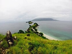 Maripipi Island as seen from Sambawan Island | |
 Flag | |
 Map of Biliran with Maripipi highlighted | |
OpenStreetMap .mw-parser-output .locmap .od{position:absolute}.mw-parser-output .locmap .id{position:absolute;line-height:0}.mw-parser-output .locmap .l0{font-size:0;position:absolute}.mw-parser-output .locmap .pv{line-height:110%;position:absolute;text-align:center}.mw-parser-output .locmap .pl{line-height:110%;position:absolute;top:-0.75em;text-align:right}.mw-parser-output .locmap .pr{line-height:110%;position:absolute;top:-0.75em;text-align:left}.mw-parser-output .locmap .pv>div{display:inline;padding:1px}.mw-parser-output .locmap .pl>div{display:inline;padding:1px;float:right}.mw-parser-output .locmap .pr>div{display:inline;padding:1px;float:left}html.skin-theme-clientpref-night .mw-parser-output .od,html.skin-theme-clientpref-night .mw-parser-output .od .pv>div,html.skin-theme-clientpref-night .mw-parser-output .od .pl>div,html.skin-theme-clientpref-night .mw-parser-output .od .pr>div{background:#000;color:#fff}html.skin-theme-clientpref-night .mw-parser-output .locmap{filter:grayscale(0.6)}@media(prefers-color-scheme:dark){html.skin-theme-clientpref-os .mw-parser-output .locmap{filter:grayscale(0.6)}html.skin-theme-clientpref-os .mw-parser-output .od,html.skin-theme-clientpref-os .mw-parser-output .od .pv>div,html.skin-theme-clientpref-os .mw-parser-output .od .pl>div,html.skin-theme-clientpref-os .mw-parser-output .od .pr>div{background:#000;color:#fff}}  Maripipi Location within the Philippines | |
| Coordinates: 11°47′N 124°21′E / 11.78°N 124.35°E | |
| Country | Philippines |
| Region | Eastern Visayas |
| Province | Biliran |
| District | Lone district |
| Barangays | 15 (see Barangays) |
| Government | |
| • Type | Sangguniang Bayan |
| • Mayor | Joseph C. Caingcoy |
| • Vice Mayor | Felisa S. Mulles |
| • Representative | Gerardo J. Espina Jr. |
| • Councilors | List |
| • Electorate | 5,224 voters (2022) |
| Area | |
| • Total | 27.83 km2 (10.75 sq mi) |
| Highest elevation (Mount Maripipi) | 924 m (3,031 ft) |
| Lowest elevation | 0 m (0 ft) |
| Population (2020 census)[3] | |
| • Total | 6,373 |
| • Density | 230/km2 (590/sq mi) |
| • Households | 1,641 |
| Economy | |
| • Income class | 5th municipal income class |
| • Poverty incidence | 20.42 |
| • Revenue | ₱ 57.33 million (2020) |
| • Assets | ₱ 190.1 million (2020) |
| • Expenditure | ₱ 55.91 million (2020) |
| • Liabilities | ₱ 80.48 million (2020) |
| Service provider | |
| • Electricity | Biliran Electric Cooperative (BILECO) |
| Time zone | UTC+8 (PST) |
| ZIP code | 6546 |
| PSGC | 087807000 |
| IDD : area code | +63 (0)53 |
| Native languages | Waray Cebuano Tagalog |
| Website | www |
Geography edit
Maripipi Municipality is composed of Maripipi Island and surrounding islets situated northwest off the coast of Biliran Island.
According to the Philippine Statistics Authority, the municipality has a land area of 27.83 square kilometres (10.75 sq mi) [5] constituting 5.19% of the 536.01-square-kilometre- (206.95 sq mi) total area of Biliran.
Mount Maripipi is the highest point in the island with an elevation of 3,031 ft (924 m) above sea level.
Barangays edit
Maripipi is politically subdivided into 15 barangays.[6] Each barangay consists of puroks and some have sitios.
| PSGC | Barangay | Population | ±% p.a. | |||
|---|---|---|---|---|---|---|
| 2020[3] | 2010[7] | |||||
| 087807001 | Agutay | 8.2% | 523 | 511 | 0.23% | |
| 087807002 | Banlas | 3.7% | 235 | 249 | −0.58% | |
| 087807003 | Bato | 9.0% | 576 | 507 | 1.28% | |
| 087807004 | Binalayan West | 8.0% | 509 | 477 | 0.65% | |
| 087807005 | Binalayan East | 7.5% | 479 | 476 | 0.06% | |
| 087807008 | Burabod | 3.5% | 222 | 212 | 0.46% | |
| 087807009 | Calbani | 6.0% | 381 | 404 | −0.58% | |
| 087807010 | Canduhao | 5.6% | 356 | 329 | 0.79% | |
| 087807011 | Casibang | 6.8% | 431 | 379 | 1.29% | |
| 087807012 | Danao | 4.8% | 306 | 345 | −1.19% | |
| 087807014 | Ol‑og | 5.7% | 362 | 327 | 1.02% | |
| 087807015 | Binongto‑an (Poblacion Norte) | 10.2% | 653 | 578 | 1.23% | |
| 087807016 | Ermita (Poblacion Sur) | 15.5% | 988 | 831 | 1.75% | |
| 087807017 | Trabugan | 2.8% | 177 | 185 | −0.44% | |
| 087807018 | Viga | 15.1% | 961 | 889 | 0.78% | |
| Total | 6,373 | 6,699 | −0.50% | |||
Climate edit
| Climate data for Maripipi, Biliran | |||||||||||||
|---|---|---|---|---|---|---|---|---|---|---|---|---|---|
| Month | Jan | Feb | Mar | Apr | May | Jun | Jul | Aug | Sep | Oct | Nov | Dec | Year |
| Mean daily maximum °C (°F) | 28 (82) |
29 (84) |
29 (84) |
31 (88) |
31 (88) |
30 (86) |
29 (84) |
29 (84) |
29 (84) |
29 (84) |
29 (84) |
28 (82) |
29 (85) |
| Mean daily minimum °C (°F) | 21 (70) |
21 (70) |
21 (70) |
22 (72) |
23 (73) |
24 (75) |
24 (75) |
25 (77) |
24 (75) |
24 (75) |
23 (73) |
22 (72) |
23 (73) |
| Average precipitation mm (inches) | 72 (2.8) |
52 (2.0) |
65 (2.6) |
62 (2.4) |
87 (3.4) |
129 (5.1) |
153 (6.0) |
124 (4.9) |
147 (5.8) |
157 (6.2) |
139 (5.5) |
117 (4.6) |
1,304 (51.3) |
| Average rainy days | 17.4 | 13.4 | 16.8 | 18.0 | 22.2 | 25.3 | 26.2 | 24.2 | 24.9 | 26.0 | 23.3 | 20.8 | 258.5 |
| Source: Meteoblue[8] | |||||||||||||
Demographics edit
| Year | Pop. | ±% p.a. |
|---|---|---|
| 1903 | 1,956 | — |
| 1918 | 3,463 | +3.88% |
| 1939 | 5,433 | +2.17% |
| 1948 | 6,550 | +2.10% |
| 1960 | 7,155 | +0.74% |
| 1970 | 6,978 | −0.25% |
| 1975 | 7,949 | +2.65% |
| 1980 | 7,379 | −1.48% |
| 1990 | 6,943 | −0.61% |
| 1995 | 7,853 | +2.33% |
| 2000 | 8,319 | +1.24% |
| 2007 | 6,946 | −2.46% |
| 2010 | 6,699 | −1.31% |
| 2015 | 7,159 | +1.27% |
| 2020 | 6,373 | −2.26% |
| Source: Philippine Statistics Authority[9][7][10][11] | ||
In the 2020 census, Maripipi had a population of 6,373.[3] The population density was 230 inhabitants per square kilometre (600/sq mi).
Economy edit
References edit
- ^ Municipality of Maripipi | (DILG)
- ^ "2015 Census of Population, Report No. 3 – Population, Land Area, and Population Density" (PDF). Philippine Statistics Authority. Quezon City, Philippines. August 2016. ISSN 0117-1453. Archived (PDF) from the original on May 25, 2021. Retrieved July 16, 2021.
- ^ a b c d Census of Population (2020). "Region VIII (Eastern Visayas)". Total Population by Province, City, Municipality and Barangay. Philippine Statistics Authority. Retrieved 8 July 2021.
- ^ "PSA Releases the 2018 Municipal and City Level Poverty Estimates". Philippine Statistics Authority. 15 December 2021. Retrieved 22 January 2022.
- ^ "Province: Biliran". PSGC Interactive. Quezon City, Philippines: Philippine Statistics Authority. Retrieved 12 November 2016.
- ^ "Municipal: Maripipi". PSGC Interactive. Quezon City, Philippines: Philippine Statistics Authority. Retrieved 8 January 2016.
- ^ a b Census of Population and Housing (2010). "Region VIII (Eastern Visayas)" (PDF). Total Population by Province, City, Municipality and Barangay. National Statistics Office. Retrieved 29 June 2016.
- ^ "Maripipi: Average Temperatures and Rainfall". Meteoblue. Retrieved 29 February 2020.
- ^ Census of Population (2015). "Region VIII (Eastern Visayas)". Total Population by Province, City, Municipality and Barangay. Philippine Statistics Authority. Retrieved 20 June 2016.
- ^ Censuses of Population (1903–2007). "Region VIII (Eastern Visayas)". Table 1. Population Enumerated in Various Censuses by Province/Highly Urbanized City: 1903 to 2007. National Statistics Office.
{{cite encyclopedia}}: CS1 maint: numeric names: authors list (link) - ^ "Province of Biliran". Municipality Population Data. Local Water Utilities Administration Research Division. Retrieved 17 December 2016.
- ^ "Poverty incidence (PI):". Philippine Statistics Authority. Retrieved December 28, 2020.
- ^ "Estimation of Local Poverty in the Philippines" (PDF). Philippine Statistics Authority. 29 November 2005.
- ^ "2003 City and Municipal Level Poverty Estimates" (PDF). Philippine Statistics Authority. 23 March 2009.
- ^ "City and Municipal Level Poverty Estimates; 2006 and 2009" (PDF). Philippine Statistics Authority. 3 August 2012.
- ^ "2012 Municipal and City Level Poverty Estimates" (PDF). Philippine Statistics Authority. 31 May 2016.
- ^ "Municipal and City Level Small Area Poverty Estimates; 2009, 2012 and 2015". Philippine Statistics Authority. 10 July 2019.
- ^ "PSA Releases the 2018 Municipal and City Level Poverty Estimates". Philippine Statistics Authority. 15 December 2021. Retrieved 22 January 2022.
External links edit
 Media related to Maripipi at Wikimedia Commons
- Philippine Standard Geographic Code