


Summary
Mary Esther is a city in Okaloosa County, Florida, United States. It is part of the Fort Walton Beach–Crestview–Destin Metropolitan Statistical Area. The population was 3,982 at the 2020 US census.
Mary Esther, Florida | |||||||||||||||||||||||||||||||||||||||||||||||||||||||||||||||||||||||||||||||||||||||||||
|---|---|---|---|---|---|---|---|---|---|---|---|---|---|---|---|---|---|---|---|---|---|---|---|---|---|---|---|---|---|---|---|---|---|---|---|---|---|---|---|---|---|---|---|---|---|---|---|---|---|---|---|---|---|---|---|---|---|---|---|---|---|---|---|---|---|---|---|---|---|---|---|---|---|---|---|---|---|---|---|---|---|---|---|---|---|---|---|---|---|---|---|
| City of Mary Esther, Florida | |||||||||||||||||||||||||||||||||||||||||||||||||||||||||||||||||||||||||||||||||||||||||||
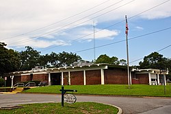 Mary Esther City Hall, September 2014. | |||||||||||||||||||||||||||||||||||||||||||||||||||||||||||||||||||||||||||||||||||||||||||
| Motto: "A Growing Community " | |||||||||||||||||||||||||||||||||||||||||||||||||||||||||||||||||||||||||||||||||||||||||||
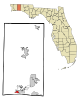 Location in Okaloosa County and the state of Florida | |||||||||||||||||||||||||||||||||||||||||||||||||||||||||||||||||||||||||||||||||||||||||||
| Coordinates: 30°24′44″N 86°39′33″W / 30.41222°N 86.65917°W | |||||||||||||||||||||||||||||||||||||||||||||||||||||||||||||||||||||||||||||||||||||||||||
| Country | |||||||||||||||||||||||||||||||||||||||||||||||||||||||||||||||||||||||||||||||||||||||||||
| State | |||||||||||||||||||||||||||||||||||||||||||||||||||||||||||||||||||||||||||||||||||||||||||
| County | Okaloosa | ||||||||||||||||||||||||||||||||||||||||||||||||||||||||||||||||||||||||||||||||||||||||||
| Incorporated | 1946 | ||||||||||||||||||||||||||||||||||||||||||||||||||||||||||||||||||||||||||||||||||||||||||
| Government | |||||||||||||||||||||||||||||||||||||||||||||||||||||||||||||||||||||||||||||||||||||||||||
| • Type | Council-Manager | ||||||||||||||||||||||||||||||||||||||||||||||||||||||||||||||||||||||||||||||||||||||||||
| • Mayor | Christopher "Chris" Stein | ||||||||||||||||||||||||||||||||||||||||||||||||||||||||||||||||||||||||||||||||||||||||||
| • Mayor Pro Tem | Larry Carter | ||||||||||||||||||||||||||||||||||||||||||||||||||||||||||||||||||||||||||||||||||||||||||
| • Councilmembers | April Sutton, Bernie Oder, Susan Coxwell, and Jan Lipscomb | ||||||||||||||||||||||||||||||||||||||||||||||||||||||||||||||||||||||||||||||||||||||||||
| • City Manager | Jared Cobb | ||||||||||||||||||||||||||||||||||||||||||||||||||||||||||||||||||||||||||||||||||||||||||
| • City Clerk | Valerie Broxson | ||||||||||||||||||||||||||||||||||||||||||||||||||||||||||||||||||||||||||||||||||||||||||
| Area | |||||||||||||||||||||||||||||||||||||||||||||||||||||||||||||||||||||||||||||||||||||||||||
| • Total | 1.46 sq mi (3.79 km2) | ||||||||||||||||||||||||||||||||||||||||||||||||||||||||||||||||||||||||||||||||||||||||||
| • Land | 1.46 sq mi (3.77 km2) | ||||||||||||||||||||||||||||||||||||||||||||||||||||||||||||||||||||||||||||||||||||||||||
| • Water | 0.01 sq mi (0.02 km2) | ||||||||||||||||||||||||||||||||||||||||||||||||||||||||||||||||||||||||||||||||||||||||||
| Elevation | 23 ft (7 m) | ||||||||||||||||||||||||||||||||||||||||||||||||||||||||||||||||||||||||||||||||||||||||||
| Population (2020) | |||||||||||||||||||||||||||||||||||||||||||||||||||||||||||||||||||||||||||||||||||||||||||
| • Total | 3,982 | ||||||||||||||||||||||||||||||||||||||||||||||||||||||||||||||||||||||||||||||||||||||||||
| • Density | 2,736.77/sq mi (1,056.63/km2) | ||||||||||||||||||||||||||||||||||||||||||||||||||||||||||||||||||||||||||||||||||||||||||
| Time zone | UTC-6 (Central (CST)) | ||||||||||||||||||||||||||||||||||||||||||||||||||||||||||||||||||||||||||||||||||||||||||
| • Summer (DST) | UTC-5 (CDT) | ||||||||||||||||||||||||||||||||||||||||||||||||||||||||||||||||||||||||||||||||||||||||||
| ZIP code | 32569 | ||||||||||||||||||||||||||||||||||||||||||||||||||||||||||||||||||||||||||||||||||||||||||
| Area code | 850 | ||||||||||||||||||||||||||||||||||||||||||||||||||||||||||||||||||||||||||||||||||||||||||
| FIPS code | 12-43375[2] | ||||||||||||||||||||||||||||||||||||||||||||||||||||||||||||||||||||||||||||||||||||||||||
| GNIS feature ID | 0286480[3] | ||||||||||||||||||||||||||||||||||||||||||||||||||||||||||||||||||||||||||||||||||||||||||
| Website | cityofmaryesther | ||||||||||||||||||||||||||||||||||||||||||||||||||||||||||||||||||||||||||||||||||||||||||
|
Etymology
edit
Mary Esther gets its name from its first postmaster, John Newton, who named it for both of his daughters.[4] Geography editMary Esther is located at 30°24′44″N 86°39′33″W / 30.412266°N 86.659044°W.[5] U.S. Route 98 is the main route through the city, leading east 4 mi (6 km) to Fort Walton Beach and west 37 mi (60 km) to Pensacola. According to the United States Census Bureau, the city has a total area of 1.5 square miles (3.9 km2), all land. Climate editClimate is characterized by relatively high temperatures and evenly distributed precipitation throughout the year. This climate type is found on the eastern sides of the continents between 20° and 35° N and S latitude. The Köppen Climate Classification subtype for this climate is "Cfa" (C = mild temperate, f = fully humid, and a = hot summer), which is a humid subtropical climate zone.[6] Demographics edit
2010 and 2020 census edit
As of the 2020 United States census, there were 3,982 people, 1,573 households, and 1,149 families residing in the city.[10] As of the 2010 United States census, there were 3,851 people, 1,770 households, and 1,071 families residing in the city.[11] 2000 census editAt the 2000 census there were 4,055 people in 1,623 households, including 1,147 families, in the city. The population density was 2,635.0 inhabitants per square mile (1,017.4/km2). There were 1,732 housing units at an average density of 1,125.5 per square mile (434.6/km2). The racial makeup of the city was 83.65% White, 6.46% African American, 0.96% Native American, 3.77% Asian, 0.17% Pacific Islander, 1.21% from other races, and 3.77% from two or more races. Hispanic or Latino of any race were 4.09%.[2] Of the 1,623 households in 2000, 29.0% had children under the age of 18 living with them, 57.0% were married couples living together, 9.9% had a female householder with no husband present, and 29.3% were non-families. 21.7% of households were one person and 7.0% were one person aged 65 or older. The average household size was 2.50 and the average family size was 2.93. In 2000, the age distribution was 23.4% under the age of 18, 7.8% from 18 to 24, 30.5% from 25 to 44, 25.1% from 45 to 64, and 13.3% 65 or older. The median age was 39 years. For every 100 females, there were 102.3 males. For every 100 females age 18 and over, there were 100.1 males. In 2000, the median household income was $42,647 and the median family income was $47,917. Males had a median income of $31,030 versus $20,319 for females. The per capita income for the city was $22,488. About 4.1% of families and 5.7% of the population were below the poverty line, including 8.8% of those under age 18 and 1.0% of those age 65 or over. Libraries editThe idea of a public library was first proposed on February 4, 1974, to the then Mayor Tom Pryor. The library was first named the Mary Esther Community Library. It was run by volunteers and not tax supported. The original building was only 585 square feet, with annual fees ranging from $1.00 per person to $5.00 for a family. The building was later able to get an expansion to 810 square feet. The Mary Esther Community Library was then renamed in October 1976 to the current name of the Mary Esther Public Library. In 1988 when the space for the library was deemed too small, the Friends of the Library group created a petition for the citizens calling on the City Council to build a newer, bigger library. On February 6, 1989, the City Council approved the new site and size of the library. While the new library was being built the state of Florida also elected to give $175,000 dollars in matching funds to help with construction. Ground was broken on February 28, 1991, and the new Mary Esther Public Library opened to the public on March 9, 1992. Throughout the history of the Mary Esther Public Library there was talk of an Okaloosa County Library System, but it was repeatedly denied.[12] The Okaloosa County Public Library Cooperative eventually formed in 1997 with Mary Esther as one of the member libraries.[13] The library received its most recent renovation in 2004 after receiving a $350,000 grant, adding an additional 2,000 square feet.[14] References edit
External links edit
| |||||||||||||||||||||||||||||||||||||||||||||||||||||||||||||||||||||||||||||||||||||||||||