
KNOWPIA
WELCOME TO KNOWPIA

Masjed Soleyman County 
Summary
Masjed Soleyman County (Persian: شهرستان مسجد سلیمان) is in Khuzestan province, Iran. Its capital is the city of Masjed Soleyman.[3]
Masjed Soleyman County
Persian: شهرستان مسجد سلیمان | |
|---|---|
County | |
 Shahid Abbaspour Dam | |
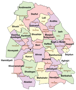 Location of Masjed Soleyman County in Khuzestan province (center right, pink) | |
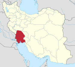 Location of Khuzestan province in Iran | |
| Coordinates: 32°01′N 49°21′E / 32.017°N 49.350°E[1] | |
| Country | Iran |
| Province | Khuzestan |
| Capital | Masjed Soleyman |
| Districts | Central, Anbar, Golgir |
| Population (2016)[2] | |
| • Total | 113,419 |
| Time zone | UTC+3:30 (IRST) |
At the 2006 census, the county's population was 167,226 in 33,484 households.[4] The following census in 2011 counted 113,257 people in 26,804 households,[5] by which time Andika District had been separated from the county to form Andika County.[6] At the 2016 census, Masjed Soleyman County's population was 113,419 in 30,115 households.[2]
Administrative divisions edit
The population history and structural changes of Masjed Soleyman County's administrative divisions over three consecutive censuses are shown in the following table. The latest census shows three districts, six rural districts, and two cities.[2]
| Administrative Divisions | 2006[4] | 2011[5] | 2016[2] |
|---|---|---|---|
| Central District | 117,796 | 106,991 | 104,059 |
| Jahangiri RD | 3,981 | 2,122 | 2,469 |
| Jahangiri-ye Shomali RD | 1,500 | 1,093 | |
| Tembi Golgir RD | 4,619 | ||
| Tolbozan RD | 3,075 | ||
| Masjed Soleyman (city) | 106,121 | 103,369 | 100,497 |
| Anbar District | 2,045 | ||
| Anbar RD | 1,262 | ||
| Zeylabi RD | 783 | ||
| Andika District1 | 49,430 | ||
| Abezhdan RD | 13,493 | ||
| Chelo RD | 5,118 | ||
| Kushk RD | 8,479 | ||
| Lalar and Katak RD | 3,991 | ||
| Qaleh-ye Khvajeh RD | 13,094 | ||
| Shalal and Dasht-e Gol RD | 4,454 | ||
| Qaleh-ye Khvajeh (city) | 801 | ||
| Golgir District | 5,527 | 7,238 | |
| Tembi Golgir RD | 3,672 | 3,664 | |
| Tolbozan RD | 1,855 | 2,485 | |
| Golgir (city) | 1,089 | ||
| Total | 167,226 | 113,257 | 113,419 |
| 1Became a part of Andika County[6] | |||
Wikimedia Commons has media related to Masjed Soleyman County.
References edit
- ^ OpenStreetMap contributors (1 April 2024). "Masjed Soleyman County" (Map). OpenStreetMap. Retrieved 1 April 2024.
- ^ a b c d "Census of the Islamic Republic of Iran, 1395 (2016)". AMAR (in Persian). The Statistical Center of Iran. p. 06. Archived from the original (Excel) on 21 October 2020. Retrieved 19 December 2022.
- ^ Habibi, Hassan. "Approval of the organization and chain of citizenship of the elements and units of the national divisions of Khuzestan province, centered in the city of Ahvaz". Islamic Parliament Research Center (in Persian). Ministry of Interior, Political and Defense Commission of the Government Board. Archived from the original on 17 July 2014. Retrieved 25 January 2024.
- ^ a b "Census of the Islamic Republic of Iran, 1385 (2006)". AMAR (in Persian). The Statistical Center of Iran. p. 06. Archived from the original (Excel) on 20 September 2011. Retrieved 25 September 2022.
- ^ a b "Census of the Islamic Republic of Iran, 1390 (2011)". Syracuse University (in Persian). The Statistical Center of Iran. p. 06. Archived from the original (Excel) on 18 January 2023. Retrieved 19 December 2022.
- ^ a b Davodi, Parviz. "Approval letter regarding the reforms of country divisions in Khuzestan province, Masjed Soleyman County". Dastour (in Persian). Ministry of Interior, Political and Defense Commission. Archived from the original on 5 November 2023. Retrieved 5 November 2023.