


Summary
The Massif du Nord is the longest mountain range of Haiti.[2]
| Massif du Nord | |
|---|---|
 Massif du Nord | |
| Highest point | |
| Elevation | 1,219.2[1] m (4,000 ft) |
| Coordinates | 19°35′0″N 72°25′0″W / 19.58333°N 72.41667°W |
| Geography | |
| Location | Haiti |
Geography edit
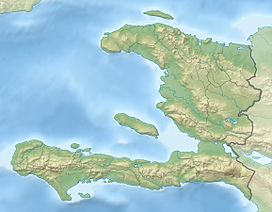
The mountain range is located in the northern region of Haiti, in the departments of the Nord and in Artibonite. The range's altitude varies from 600–1,210 metres (1,970–3,970 ft). The Plaine-du-Nord lies along the northern border with the Dominican Republic, between the Massif du Nord and the North Atlantic Ocean. This lowland area of 2,000 km2 (770 sq mi) is about 150 km (90 mi) long and 30 km (20 mi) wide.
It is the western extension of the Cordillera Central that runs through the Dominican Republic.[3][4] This channel extends to the northwest under the name of the Chaîne du Haut-Piton.
A narrow northern coastal plain lies north of the range on the Caribbean Sea. The Guayamouc River flows south from the range.[5]
The Massif du Nord separates the city of Cap-Haïtien from the capital Port-au-Prince.
History edit
After the Haitian Revolution, the Citadelle Laferrière was built by King Henri Christophe. It overlooks the city of Cap-Haïtien from its height of 865 m (2,838 ft).[6]
See also edit
- Mountain ranges of the Caribbean
References edit
- ^ Famous Landforms in Haiti
- ^ Matibag, Eugenio (2003). Haitian-Dominican Counterpoint. p. 19. ISBN 9781403973801. Retrieved 20 June 2015.
- ^ Britannica: Massif du Nord
- ^ Mann, Paul; Draper, Grenville; Lewis, John F., eds. (1991). Geologic and Tectonic Development of the North America-Caribbean Plate Boundary in Hispaniola. p. 10. ISBN 0813722624. Retrieved 20 June 2015.
- ^ Country Studies - Haiti: Geography
- ^ Du Boi, Coert (1942). "Caribbean Tourist Trade: A Regional Approach". p. 62. Retrieved 20 June 2015.