


Summary
Mato Grosso (Portuguese pronunciation: [ˈmatu ˈɡɾosu] ⓘ – lit. 'Thick Bush') is one of the states of Brazil, the third largest by area, located in the Central-West region.[4] The state has 1.66% of the Brazilian population and is responsible for 1.9% of the Brazilian GDP.
Mato Grosso | |
|---|---|
| Estado de Mato Grosso State of Mato Grosso | |
 Coat of arms | |
| Motto(s): | |
| Anthem: "Hino de Mato Grosso" | |
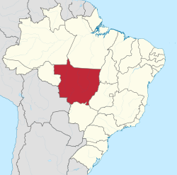 Location of Mato Grosso (in red) in Brazil | |
| Coordinates: 15°34′00″S 56°04′30″W / 15.56667°S 56.07500°W | |
| Country | |
| Capital and largest city | Cuiabá |
| Government | |
| • Governor | Mauro Mendes (UNIÃO) |
| • Vice Governor | Otaviano Pivetta (Republicanos) |
| • Senators | Jayme Campos (UNIÃO) Margareth Buzetti (PP) Wellington Fagundes (PL) |
| Area | |
| • Total | 903,357 km2 (348,788 sq mi) |
| • Rank | 3rd |
| Highest elevation (Serra das Furnas) | 902 m (2,959 ft) |
| Population (2007)[1] | |
| • Total | 3,035,122 |
| • Estimate (2019) | 3,484,466 |
| • Rank | 17th |
| • Density | 3.4/km2 (8.7/sq mi) |
| • Rank | 25th |
| Demonym | Mato-grossense |
| GDP | |
| • Total | R$ 233.390 billion (US$ 43.294 billion) |
| HDI | |
| • Year | 2021 |
| • Category | 0.736[3] – high (11th) |
| Time zone | UTC-4 (BRT-1) |
| Postal Code | 78000-000 to 78890-000 |
| ISO 3166 code | BR-MT |
| Website | mt.gov.br |

Neighboring states (from west clockwise) are: Rondônia, Amazonas, Pará, Tocantins, Goiás and Mato Grosso do Sul. The state is roughly 82.2% of the size of its southwest neighbor, the nation of Bolivia. A state with a flat landscape that alternates between vast chapadas and plain areas, Mato Grosso contains three main ecosystems: the Cerrado, the Pantanal and the Amazon rainforest.
The Chapada dos Guimarães National Park, with its caves, grottoes, tracks, and waterfalls, is one of its tourist attractions. The extreme northwest of the state has a small part of the Amazonian forest. The Xingu Indigenous Park and the Araguaia River are in Mato Grosso. Farther south, the Pantanal, the world's largest wetland, is the habitat for nearly one thousand species of animals and many aquatic birds.
Geography edit

The terrain of Mato Grosso is varied and includes cliffs, canyons, and waterfalls. It is home to the Chapada dos Guimarães National Park, a unique environment of sandstone mountains that have eroded into amazingly varied terrain.
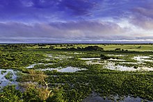
The biologically rich Pantanal, one of the world's largest wetland/prairie ecosystems, is also located within this state. The Paraguay basin is very rich in the number and diversity of fish (around 230 species), considered a privileged place by fishermen and scholars of this group of animals. In this basin there are numerous species classified as “noble” in sport fishing, others of great interest to aquarists such as ornamental species, and still others, which, due to their interest and rarity from a scientific point of view, have merited detailed studies and research. The fishing industry in the Pantanal plays an important role in the region's economy and, for local populations, fish is, without a doubt, a staple food.[5] The Pantanal has a habitat similar to that of the Everglades in Florida in the United States, although the Pantanal is on a much larger scale.
History edit
The Bororo Indians live in the Mato Grosso area. As late as 1880, soldiers patrolled lands on the outskirts of Cuiabá, Mato Grosso's capital and largest city, to protect settlers from Bororo raids.
By the end of the 19th century, although severely reduced by disease and by warfare with explorers, slave traders, prospectors, settlers, and other indigenous groups, as many as five to 10 thousand Bororo continued to occupy central and eastern Mato Grosso, as well as western Goiás.[6] The southwestern part of this state was ceded by Brazil to Bolivia in exchange for the then-Bolivian territory of Acre, according to the Treaty of Petrópolis in 1903.
This historically remote area attracted expeditions of exploration in the early 20th century that sought to find lost civilizations. A notable example was British Captain Percy Fawcett's expedition to find the Lost City of Z which he believed existed in the jungles of Brazil. Certain proponents of the Hollow Earth hypothesis speculated that the region had sites of access to the interior of the earth and its settlements.
In 1977, the state was split into two halves, and the neighboring state of Mato Grosso do Sul was created from the other part of its territory.
Demographics edit

Mato Grosso had a high rate of population growth in the 20th century due to timber, ranching and agricultural development. The state as a whole has one of the lowest population densities of any Brazilian state. According to the Brazilian Institute of Geography and Statistics (IBGE), 3,441,998 people resided in the state as of 2018. The population density was 3.8 inhabitants/km2.
- Urbanization: 76.6% (2006)
- Population growth: 2.4% (1991–2000)
- Houses: 836,000 (2006)[7]
Ethnically, the state includes a relatively high proportion of caboclos (persons of mixed European and Indian ancestry), as do other areas of interior Brazil. The last PNAD (National Research for Sample of Domiciles) census revealed the following numbers: 2,048,782 Brown (Mixed) people (56%); 1,181,590 White people (32.3%); 360,698 Black people (9.9%); 56,687 Amerindian people (1.5%); and 10,813 Asian people (0.3%).[8] At the 2022 census, the most commonly nominated ethnic groups as a proportion of the total population were:[citation needed]
| Race and Ethnicity[9] | Total | |
|---|---|---|
| Pardo | 56% | |
| White | 32.30% | |
| African Black | 9.86% | |
| Indigenous | 1.55% | |
| Yellow | 0.30% | |
Largest cities edit
Largest cities or towns in Mato Grosso
(2011 census by the Brazilian Institute of Geography and Statistics)[10] | |||||||||
|---|---|---|---|---|---|---|---|---|---|
| Rank | Mesoregion | Pop. | Rank | Mesoregion | Pop. | ||||
 Cuiabá  Várzea Grande |
1 | Cuiabá | Centro-Sul | 556,298 | 11 | Lucas do Rio Verde | Norte | 47,570 |  Rondonópolis  Sinop |
| 2 | Várzea Grande | Centro-Sul | 255,448 | 12 | Pontes e Lacerda | Sudoeste | 41,741 | ||
| 3 | Rondonópolis | Sudeste | 198,949 | 13 | Juína | Norte | 39,350 | ||
| 4 | Sinop | Norte | 116,013 | 14 | Juara | Norte | 36,168 | ||
| 5 | Cáceres | Centro-Sul | 88,427 | 15 | Barra do Bugres | Norte | 33,034 | ||
| 6 | Tangará da Serra | Sudoeste | 84,076 | 16 | Campo Verde | Centro-Sul | 32,692 | ||
| 7 | Sorriso | Norte | 68,894 | 17 | Guarantã do Norte | Norte | 32,524 | ||
| 8 | Barra do Garças | Nordeste | 56,903 | 18 | Nova Mutum | Centro-Sul | 32,134 | ||
| 9 | Primavera do Leste | Sudeste | 53,003 | 19 | Poconé | Centro-Sul | 31,856 | ||
| 10 | Alta Floresta | Norte | 49,331 | 20 | Peixoto de Azevedo | Centro-Sul | 31,169 | ||
Education edit

Portuguese is the official national language and the primary language taught in schools. English and Spanish are also taught as part of the official high school curriculum.
More than 58 universities are located in the state of Mato Grosso.[11]
Cuiabá is home to the following universities:
- Federal University of Mato Grosso (UFMT);
- Mato Grosso State University (Unemat);
- Universidade de Cuiabá (Unic).
Rondonópolis also has the Federal University of Rondonópolis (UFR), formerly a part of UFMT until 2018.
Economy edit


Agriculture is the largest component of the state's GDP at 40.8%, followed by the service sector at 40.2%. The industrial sector represents 19% of the GDP (2004). Mato Grosso's major exports include soybeans (83%), wood (5.6%), meats (4.8%), and cotton (3.3%) (2002).
The state's share of the Brazilian economy is 1.8% (2014). In 2020, Mato Grosso was the leader in national grain production, with 28.0%.[12] It's the largest producer of soy in Brazil, with 26.9% of the total produced in 2020 (33.0 million tons); the largest producer of maize in the country;[13] the largest producer of cotton in Brazil, with around 65% of national production (1.8 out of the 2.8 million tons harvested in the country).;[14][15] the sixth largest producer of sugarcane in the country, 16 million tons harvested in the 2019/20 harvest.;[16][12] and the third largest producer of beans, with 10.5% of Brazilian production.[12] In sunflowers, the state was the largest national producer in 2019, with 60,000 tons.[17] In cassava production, Brazil produced a total of 17.6 million tons in 2018. Mato Grosso produced 287,000 tons that year.[18]
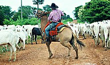
In 2019, the cattle herd from Mato Grosso reached the mark of 30 million cattle, the largest cattle herd in the country, representing almost 14% of national production alone. In 2018, Mato Grosso was the fifth largest pork producer in the country, with a herd of around 2.5 million animals.[19][20][21][22]
In 2017, Mato Grosso had 1.15% of the national mineral participation (fifth place in the country). Mato Grosso had production of gold (8.3 tons at a value of R$1 billion) and tin (536 tons at a value of R$16 million).[23] In addition, in gemstones, the state is the second largest national producer of diamond, having extracted 49,000 carats in the year 2017. The city of Juína is the main one in this activity in the state. The state also has a small production of sapphire and jasper.[24][25]
Mato Grosso had an industrial GDP of R$17.0 billion in 2017, equivalent to 1.4% of the national industry. It employs 141,121 workers in the industry. The main industrial sectors are: Construction (32.0%), Food (27.9%), Industrial Services of Public Utility, such as Electricity and Water (18.6%), Beverages (4.5%) and Oil Products Oil and Biofuels (3.9%). These five sectors concentrate 86.9% of the state's industry.[26]
Statistics edit
- Vehicles: 1,614,797 (January 2015)
- Mobile phones: 4,500,000 (January 2015)
- Telephones: 527,000 (April 2007)
- Cities: 141 (2007)[27]
Infrastructure edit
Roads edit

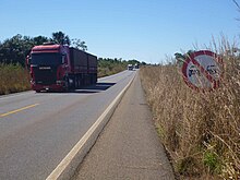
Mato Grosso had, in 2020, 141,171 km of municipal roads; on the roads of the state of Mato Grosso there were 22,399 km of unpaved roads, 7,281 km of paved roads and 81 km of duplicated highways. In the federal road network, there were 3,649 km of roads, including 330 km of duplicated highways. Mato Grosso, despite being a more recently occupied state, already has a 2-lane highway in each direction connecting the capital Cuiabá to one of the largest cities in the state, Rondonópolis, then to the border with Mato Grosso do Sul.[28][29][30][31][32]
Some of the main roads are:
Airports edit

Marechal Rondon International Airport, located 10 km (6.2 mi) from the city center of Cuiabá, in the suburb of Várzea Grande, started receiving international flights in 1996. It now serves more than half a million passengers a year.
The runway at Marechal Rondon was opened to traffic in 1956. In February 1975, Infraero took over the airport's administration and began various upgrades to meet the needs of the airport complex.
Railways edit
The 1,600 mm (5 ft 3 in) Northern Brazil Railway connects Mato Grosso with the state of São Paulo and sea ports. Rumo Logística only operates freight trains on the line, which runs as far inland as Rondonópolis.[33] An extension northward to Cuiabá and Lucas do Rio Verde is planned as of 2021.[34]
It crosses the large Rollemberg–Vuolo Bridge over the Paraná River when passing into Mato Grosso do Sul.
Flag edit

The state flag has similar colors to the flag of Brazil, with blue symbolizing the sky, green vegetation, and white standing for peace. The star is yellow to symbolize the gold which attracted the first settlers. The flag was adopted by Decree No. 2 of January 31, 1890, just a few days after the adoption of the national flag. The Mato Grosso state flag was abolished by Law No. 1.046 of October 8, 1929, but reinstated by Article 140 of the Constitution of the State of Mato Grosso on July 11, 1947.
Tourism and recreation edit
Alta Floresta edit
Fishing in the Teles Pires, São Benedito and Azul rivers is productive practically all year long.
Chapada dos Guimarães edit
The largest sandstone cavern in Brazil, Aroe Jari, extends nearly 1,550 m (5,090 ft), and several prehistoric inscriptions can be found inside.
North Pantanal edit
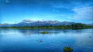
The Pantanal's backbone is the Paraguay River, which cuts through the region from north to south. The Miranda, Aquidauna, Taquari, and Cuiabá rivers flow into the Paraguay River. From October to April, the high waters reveal outsized lakes, bays, river branches, and outlets.
The Transpantaneira Highway connects the town of Poconé to Jofre Port, along the Cuiabá River bank. It is a dirt road with 126 wooden bridges, and extends for 149 km (93 mi). On the way, it is possible to observe wild animals, especially alligators, capybaras, and birds, among other wild animals.
Águas Quentes State Park edit
The 1,487 ha (3,670 acres) Águas Quentes State Park, the first protected area in Mato Grosso, is known for the healing powers of its thermal waters.[35]
Lagoa Azul State Park edit
The Gruta da Lagoa Azul State Park (Portuguese: Parque Estadual Gruta da Lagoa Azul) is a state park in the municipality of Nobres, Mato Grosso, with an area of 12,513 ha (30,920 acres).[36] Its primary attraction is a limestone cave with a pool of blue water and unusual cave formations. These have suffered from vandalism, causing the cave to be closed until measures to protect it could be implemented. The blue lagoon cave holds a pool of blue water formed from underground water of the Saloba River.[37] The main entrance is filled in part by the water. The hall contains columns over 5 m (16 ft) in size and 1 m (3 ft 3 in) in diameter. There may be archaeological remains in the cave. The park has several other limestone caves. It is covered with deciduous forests, and is home to howler monkeys, tapirs, jaguars, and macaws.[38]
Gallery edit
-
-
 Lagoon of Araras
 -
 Canyons of Chapada dos Guimarães National Park
 -
 Pantanal in Mato Grosso
 -


Sports edit

Cuiabá was one of 12 cities chosen to host the games of the 2014 FIFA World Cup, which took place in Brazil.[39]
In the state were born the medalists of the World Championships Felipe Lima in swimming and David Moura in judo, in addition to the world champions of futsal Vinícius and Lenísio.[40][41][42]
See also edit
References edit
- ^ "Projeção da população do Brasil e das Unidades da Federação" [Projected population of Brazil and the Federal States] (in Portuguese). Instituto Brasileiro de Geografia e Estatística. 1 March 2018. Archived (PDF) from the original on 18 September 2017. Retrieved 1 March 2018.
- ^ "PIB por Unidade da Federação, 2021". ibge.gov.br.
- ^ "Atlas do Desenvolvimento Humano no Brasil. Pnud Brasil, Ipea e FJP, 2022". www.atlasbrasil.org.br. Retrieved 2023-06-11.
- ^ Note: also once spelled "Matto Grosso". The town of Matto Grosso was formerly called Villa Bella." Source: Exploration of the Valley of the Amazon, vol.2, by Lieut. USN. Lardner Gibbon 1853; chapter 11. p. 275
- ^ Pantanal MS
- ^ "Myths of pacification: Brazilian frontier settlement and the subjugation of the Bororo Indians" Archived 2008-06-18 at the Wayback Machine, Encyclopedia
- ^ Source: PNAD.
- ^ Pesquisa Nacional por Amostra de Domicílios: Tabela 262 - População residente, por cor ou raça, situação e sexo [National Household Sample Survey: Table 262 - Resident population, by color or race, situation and sex] (PDF) (in Portuguese). Mato Grosso, Brazil: IBGE. 2008. ISBN 978-85-240-3919-5. Archived from the original on 2022-06-15. Retrieved 2010-01-18.
- ^ "Race and Ethnicity in Brazil: 2022 Census". ibge.gov.br. brazil Census. August 12, 2021. Retrieved December 25, 2023.
- ^ "Estimativas da população residente nos municípios brasileiros com data de referência em 1º de julho de 2011" [Estimates of the Resident Population of Brazilian Municipalities as of July 1, 2011] (PDF) (in Portuguese). Brazilian Institute of Geography and Statistics. 30 August 2011. Archived (PDF) from the original on 7 October 2011. Retrieved 31 August 2011.
- ^ "Ser Universitário - Tudo sobre o mundo universitário e estudantil!". Archived from the original on 2011-06-13. Retrieved 2011-05-16.
- ^ a b c "IBGE prevê safra recorde de grãos em 2020". 8 January 2020. Archived from the original on 2020-10-28. Retrieved 2020-07-21.
- ^ "Quatro estados concentram quase 70% da produção de grãos do país". 18 May 2017. Archived from the original on 2020-06-11. Retrieved 2020-07-21.
- ^ "Qualidade do algodão de MT é destaque em congresso nacional". 29 August 2019. Archived from the original on 2020-08-01. Retrieved 2020-07-21.
- ^ "MT segue como líder isolado na produção de algodão e safra sobe para 65% em 2017/18". Archived from the original on 2020-07-29. Retrieved 2020-07-21.
- ^ "Goiás é o segundo maior produtor de cana-de-açúcar do País". Archived from the original on 2020-08-03. Retrieved 2020-07-21.
- ^ "MT é o maior produtor de girassol do país". 26 May 2020. Archived from the original on 2020-07-23. Retrieved 2020-07-23.
- ^ "Produção brasileira de mandioca em 2018" (PDF). Archived (PDF) from the original on 2020-07-22. Retrieved 2020-07-23.
- ^ "Rebanho bovino de Mato Grosso chega a 30.3 milhões de cabeças". 22 July 2019. Archived from the original on 2022-08-20. Retrieved 2020-07-21.
- ^ "Mato Grosso tem o maior rebanho bovino do país e representa 13,8% da produção nacional". 28 September 2018. Archived from the original on 2020-08-03. Retrieved 2020-07-21.
- ^ "Para suinocultores de MT, entrada da carne suína dos EUA no Brasil agravaria a crise do setor". 20 March 2019. Archived from the original on 2020-07-04. Retrieved 2020-07-21.
- ^ "Mato Grosso prevê crescimento de 67% de sua produção de suínos nos próximos dez anos". 3 October 2018. Archived from the original on 2020-08-04. Retrieved 2020-07-21.
- ^ "Anuário Mineral Brasileiro 2018". Archived from the original on 2020-07-09. Retrieved 2020-07-21.
- ^ "Com produção de 49 mil quilates de diamante por ano, MT ocupa a 2ª colocação no ranking nacional". 27 June 2019. Archived from the original on 2020-07-18. Retrieved 2020-07-21.
- ^ "Algumas Gemas Clássicas". Archived from the original on 2019-09-06. Retrieved 2020-07-21.
- ^ "Industry Profile of Mato Grosso". Archived from the original on 2020-08-14. Retrieved 2020-07-21.
- ^ Source: IBGE.
- ^ Estradas do estado do MT, pelo SINFRA
- ^ MAPA DE MANUTENÇÃO RODOVIÁRIA MATO GROSSO - MAIO 2022
- ^ Após oito anos, Governo Federal conclui duplicação de 168 quilômetros da rodovia Cuiabá-Rondonópolis
- ^ Rota do Oeste entrega 117 km de rodovia duplicada para usuários da BR-163 entre Rondonópolis e a divisa com MS
- ^ DNIT libera mais 10 km de duplicação das rodovias 163 e 364, 45 km entre Posto Gil e Rosário Oeste duplicados
- ^ "Railways Map of Brazil". Rumo. Archived from the original on 2021-04-12. Retrieved 2021-04-12.
- ^ "MT: Ferronorte irá até Cuiabá e Lucas do Rio Verde". Portal Agrolink (in Brazilian Portuguese). 10 February 2021. Archived from the original on 2021-04-12. Retrieved 2021-04-12.
- ^ PES Águas Quentes (in Portuguese), ISA: Instituto Socioambiental, archived from the original on 2022-02-08, retrieved 2016-08-01
- ^ PES Gruta da Lagoa Azul – ISA, Informações gerais.
- ^ PES Gruta da Lagoa Azul – ISA, Características.
- ^ Parque Estadual Gruta da Lagoa Azul – Via Rural.
- ^ Cuiabá sedia copa na Arena Pantanal
- ^ Embaixador e torcedor: a vida dupla de Lenísio nos Jogos Escolares da Juventude
- ^ Felipe Lima Bio
- ^ Aos 34 anos, David Moura oficializa aposentadoria dos tatames
Sources edit
- Parque Estadual Gruta da Lagoa Azul (in Portuguese), Via Rural, archived from the original on 2016-08-06, retrieved 2016-08-03
- PES Gruta da Lagoa Azul (in Portuguese), ISA: Instituto Socioambiental, retrieved 2016-08-02
External links edit
 Media from Commons
 Travel information from Wikivoyage
- (in Portuguese) Official website of Mato Grosso