
KNOWPIA
WELCOME TO KNOWPIA

Maucomble 
Summary
Maucomble (French pronunciation: [mokɔ̃bl]) is a commune in the Seine-Maritime department in the Normandy region in northern France.
Maucomble | |
|---|---|
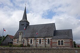 The church in Maucomble | |
Location of Maucomble .mw-parser-output .locmap .od{position:absolute}.mw-parser-output .locmap .id{position:absolute;line-height:0}.mw-parser-output .locmap .l0{font-size:0;position:absolute}.mw-parser-output .locmap .pv{line-height:110%;position:absolute;text-align:center}.mw-parser-output .locmap .pl{line-height:110%;position:absolute;top:-0.75em;text-align:right}.mw-parser-output .locmap .pr{line-height:110%;position:absolute;top:-0.75em;text-align:left}.mw-parser-output .locmap .pv>div{display:inline;padding:1px}.mw-parser-output .locmap .pl>div{display:inline;padding:1px;float:right}.mw-parser-output .locmap .pr>div{display:inline;padding:1px;float:left}html.skin-theme-clientpref-night .mw-parser-output .od,html.skin-theme-clientpref-night .mw-parser-output .od .pv>div,html.skin-theme-clientpref-night .mw-parser-output .od .pl>div,html.skin-theme-clientpref-night .mw-parser-output .od .pr>div{background:#000;color:#fff}html.skin-theme-clientpref-night .mw-parser-output .locmap{filter:grayscale(0.6)}@media(prefers-color-scheme:dark){html.skin-theme-clientpref-os .mw-parser-output .locmap{filter:grayscale(0.6)}html.skin-theme-clientpref-os .mw-parser-output .od,html.skin-theme-clientpref-os .mw-parser-output .od .pv>div,html.skin-theme-clientpref-os .mw-parser-output .od .pl>div,html.skin-theme-clientpref-os .mw-parser-output .od .pr>div{background:#000;color:#fff}}  Maucomble  Maucomble | |
| Coordinates: 49°40′58″N 1°20′03″E / 49.6828°N 1.3342°E | |
| Country | France |
| Region | Normandy |
| Department | Seine-Maritime |
| Arrondissement | Dieppe |
| Canton | Neufchâtel-en-Bray |
| Intercommunality | CC Bray-Eawy |
| Government | |
| • Mayor (2020–2026) | Léon Bachelot[1] |
| Area 1 | 5.07 km2 (1.96 sq mi) |
| Population (2021)[2] | 398 |
| • Density | 79/km2 (200/sq mi) |
| Time zone | UTC+01:00 (CET) |
| • Summer (DST) | UTC+02:00 (CEST) |
| INSEE/Postal code | 76417 /76680 |
| Elevation | 149–235 m (489–771 ft) (avg. 200 m or 660 ft) |
| 1 French Land Register data, which excludes lakes, ponds, glaciers > 1 km2 (0.386 sq mi or 247 acres) and river estuaries. | |
Geography edit
A farming and forestry village situated in the Pays de Bray, some 31 miles (50 km) southeast of Dieppe at the junction of the D118 and the D929 roads. The A28 autoroute passes through the territory of the commune.
Population edit
| Year | Pop. | ±% p.a. |
|---|---|---|
| 1968 | 303 | — |
| 1975 | 315 | +0.56% |
| 1982 | 278 | −1.77% |
| 1990 | 318 | +1.69% |
| 1999 | 321 | +0.10% |
| 2007 | 318 | −0.12% |
| 2012 | 384 | +3.84% |
| 2017 | 415 | +1.56% |
| Source: INSEE[3] | ||
Places of interest edit
- The church of St.Ouen, dating from the thirteenth century.
See also edit
References edit
- ^ Liste des maires du département de la Seine-Maritime, 10 August 2020
- ^ "Populations légales 2021". The National Institute of Statistics and Economic Studies. 28 December 2023.
- ^ Population en historique depuis 1968, INSEE
Wikimedia Commons has media related to Maucomble.