


Summary
Mauperthuis (French pronunciation: [mopɛʁtɥi] ⓘ) is a commune in the Seine-et-Marne department in the Île-de-France region in north-central France.
Mauperthuis | |
|---|---|
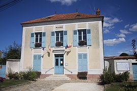 The town hall in Mauperthuis | |
 Coat of arms | |
Location of Mauperthuis .mw-parser-output .locmap .od{position:absolute}.mw-parser-output .locmap .id{position:absolute;line-height:0}.mw-parser-output .locmap .l0{font-size:0;position:absolute}.mw-parser-output .locmap .pv{line-height:110%;position:absolute;text-align:center}.mw-parser-output .locmap .pl{line-height:110%;position:absolute;top:-0.75em;text-align:right}.mw-parser-output .locmap .pr{line-height:110%;position:absolute;top:-0.75em;text-align:left}.mw-parser-output .locmap .pv>div{display:inline;padding:1px}.mw-parser-output .locmap .pl>div{display:inline;padding:1px;float:right}.mw-parser-output .locmap .pr>div{display:inline;padding:1px;float:left}html.skin-theme-clientpref-night .mw-parser-output .od,html.skin-theme-clientpref-night .mw-parser-output .od .pv>div,html.skin-theme-clientpref-night .mw-parser-output .od .pl>div,html.skin-theme-clientpref-night .mw-parser-output .od .pr>div{background:#000;color:#fff}html.skin-theme-clientpref-night .mw-parser-output .locmap{filter:grayscale(0.6)}@media(prefers-color-scheme:dark){html.skin-theme-clientpref-os .mw-parser-output .locmap{filter:grayscale(0.6)}html.skin-theme-clientpref-os .mw-parser-output .od,html.skin-theme-clientpref-os .mw-parser-output .od .pv>div,html.skin-theme-clientpref-os .mw-parser-output .od .pl>div,html.skin-theme-clientpref-os .mw-parser-output .od .pr>div{background:#000;color:#fff}}  Mauperthuis  Mauperthuis | |
| Coordinates: 48°46′07″N 3°02′22″E / 48.7686°N 3.0394°E | |
| Country | France |
| Region | Île-de-France |
| Department | Seine-et-Marne |
| Arrondissement | Meaux |
| Canton | Coulommiers |
| Intercommunality | CA Coulommiers Pays de Brie |
| Government | |
| • Mayor (2020–2026) | Dominique Carlier[1] |
| Area 1 | 1.97 km2 (0.76 sq mi) |
| Population (2021)[2] | 480 |
| • Density | 240/km2 (630/sq mi) |
| Time zone | UTC+01:00 (CET) |
| • Summer (DST) | UTC+02:00 (CEST) |
| INSEE/Postal code | 77281 /77120 |
| Elevation | 76–138 m (249–453 ft) |
| 1 French Land Register data, which excludes lakes, ponds, glaciers > 1 km2 (0.386 sq mi or 247 acres) and river estuaries. | |
The village is famous for having produced five Musketeers including d'Artagnan, who was made famous in Alexandre Dumas, père's books.[citation needed] The ruined Château d'Artagnan still exists. Much of the land once belonged to the Montesquieu Family.
This one tiny village billeted some of the US Air Service (precursor to the US Air Force) while the men flew out of the adjacent village of Saints. They were in Mauperthuis probably for just short of two months – from 8 July to 1 September 1918 out of the seven months it saw combat.
Two adjacent villages – Saints and Touquin – also play a role in the lives of these men and the US Air Service. The men were based in Touquin from the end of June until 8 July, when they moved to Saints. The men were lodged in Mauperthuis, half a mile from Saints, while they were flying out of Saints.
Quentin Roosevelt was billeted here when he was shot down and killed on 14 July 1918.
Mauperthuis was occupied by the Prussians during the Franco-Prussian War of 1870–1871. It was also overrun by the Germans for one or two days in September, 1914 before being liberated by the British under General French. It was once again in German hands from 1940 to 1944. American tanks of the US 3rd Armored Division under General Maurice Rose liberated Mauperthuis on 27 August 1944.
Geography edit
The river Aubetin forms part of the commune's south-western border.
Demographics edit
The inhabitants are called the Malperthusiens.
See also edit
References edit
- ^ "Répertoire national des élus: les maires" (in French). data.gouv.fr, Plateforme ouverte des données publiques françaises. 13 September 2022.
- ^ "Populations légales 2021". The National Institute of Statistics and Economic Studies. 28 December 2023.
External links edit
- 1999 Land Use, from IAURIF (Institute for Urban Planning and Development of the Paris-Île-de-France région) (in English)
- Base Mérimée: Search for heritage in the commune, Ministère français de la Culture. (in French)
- July 14, 2008 - 90th anniversary Commemoration of 1st Pursuit Group in France