
KNOWPIA
WELCOME TO KNOWPIA

Mazinghem 
Summary
Mazinghem (French pronunciation: [mazɛ̃ɡɛm]) is a commune in the Pas-de-Calais department in the Hauts-de-France region of France.[3]
Mazinghem | |
|---|---|
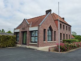 The town hall of Mazinghem | |
 Coat of arms | |
Location of Mazinghem .mw-parser-output .locmap .od{position:absolute}.mw-parser-output .locmap .id{position:absolute;line-height:0}.mw-parser-output .locmap .l0{font-size:0;position:absolute}.mw-parser-output .locmap .pv{line-height:110%;position:absolute;text-align:center}.mw-parser-output .locmap .pl{line-height:110%;position:absolute;top:-0.75em;text-align:right}.mw-parser-output .locmap .pr{line-height:110%;position:absolute;top:-0.75em;text-align:left}.mw-parser-output .locmap .pv>div{display:inline;padding:1px}.mw-parser-output .locmap .pl>div{display:inline;padding:1px;float:right}.mw-parser-output .locmap .pr>div{display:inline;padding:1px;float:left}html.skin-theme-clientpref-night .mw-parser-output .od,html.skin-theme-clientpref-night .mw-parser-output .od .pv>div,html.skin-theme-clientpref-night .mw-parser-output .od .pl>div,html.skin-theme-clientpref-night .mw-parser-output .od .pr>div{background:#000;color:#fff}html.skin-theme-clientpref-night .mw-parser-output .locmap{filter:grayscale(0.6)}@media(prefers-color-scheme:dark){html.skin-theme-clientpref-os .mw-parser-output .locmap{filter:grayscale(0.6)}html.skin-theme-clientpref-os .mw-parser-output .od,html.skin-theme-clientpref-os .mw-parser-output .od .pv>div,html.skin-theme-clientpref-os .mw-parser-output .od .pl>div,html.skin-theme-clientpref-os .mw-parser-output .od .pr>div{background:#000;color:#fff}}  Mazinghem  Mazinghem | |
| Coordinates: 50°36′14″N 2°24′20″E / 50.6039°N 2.4056°E | |
| Country | France |
| Region | Hauts-de-France |
| Department | Pas-de-Calais |
| Arrondissement | Béthune |
| Canton | Aire-sur-la-Lys |
| Intercommunality | CA Béthune-Bruay, Artois-Lys Romane |
| Government | |
| • Mayor (2020–2026) | Claudette Matton[1] |
| Area 1 | 5.19 km2 (2.00 sq mi) |
| Population (2021)[2] | 462 |
| • Density | 89/km2 (230/sq mi) |
| Time zone | UTC+01:00 (CET) |
| • Summer (DST) | UTC+02:00 (CEST) |
| INSEE/Postal code | 62564 /62120 |
| Elevation | 19–57 m (62–187 ft) (avg. 29 m or 95 ft) |
| 1 French Land Register data, which excludes lakes, ponds, glaciers > 1 km2 (0.386 sq mi or 247 acres) and river estuaries. | |
Geography edit
Mazinghem is situated some 12 miles (19 km) northwest of Béthune and 33 miles (53 km) west of Lille, at the junction of the D943 and D186 roads.
Population edit
| Year | Pop. | ±% p.a. |
|---|---|---|
| 1968 | 286 | — |
| 1975 | 298 | +0.59% |
| 1982 | 325 | +1.25% |
| 1990 | 321 | −0.15% |
| 1999 | 337 | +0.54% |
| 2007 | 410 | +2.48% |
| 2012 | 486 | +3.46% |
| 2017 | 474 | −0.50% |
| Source: INSEE[4] | ||
Places of interest edit
- The church of Notre-Dame-de-l'Annonciation, dating from the twelfth century.
- Some remains of a medieval chateau.
- The eighteenth-century chateau.
See also edit
References edit
- ^ "Répertoire national des élus: les maires". data.gouv.fr, Plateforme ouverte des données publiques françaises (in French). 2 December 2020.
- ^ "Populations légales 2021". The National Institute of Statistics and Economic Studies. 28 December 2023.
- ^ INSEE commune file
- ^ Population en historique depuis 1968, INSEE