
KNOWPIA
WELCOME TO KNOWPIA

Mecquignies 
Summary
Mecquignies (French pronunciation: [mɛkiɲi]) is a commune in the Nord department in northern France.[3]
Mecquignies | |
|---|---|
 The town hall in Mecquignies | |
 Coat of arms | |
Location of Mecquignies .mw-parser-output .locmap .od{position:absolute}.mw-parser-output .locmap .id{position:absolute;line-height:0}.mw-parser-output .locmap .l0{font-size:0;position:absolute}.mw-parser-output .locmap .pv{line-height:110%;position:absolute;text-align:center}.mw-parser-output .locmap .pl{line-height:110%;position:absolute;top:-0.75em;text-align:right}.mw-parser-output .locmap .pr{line-height:110%;position:absolute;top:-0.75em;text-align:left}.mw-parser-output .locmap .pv>div{display:inline;padding:1px}.mw-parser-output .locmap .pl>div{display:inline;padding:1px;float:right}.mw-parser-output .locmap .pr>div{display:inline;padding:1px;float:left}html.skin-theme-clientpref-night .mw-parser-output .od,html.skin-theme-clientpref-night .mw-parser-output .od .pv>div,html.skin-theme-clientpref-night .mw-parser-output .od .pl>div,html.skin-theme-clientpref-night .mw-parser-output .od .pr>div{background:#000;color:#fff}html.skin-theme-clientpref-night .mw-parser-output .locmap{filter:grayscale(0.6)}@media(prefers-color-scheme:dark){html.skin-theme-clientpref-os .mw-parser-output .locmap{filter:grayscale(0.6)}html.skin-theme-clientpref-os .mw-parser-output .od,html.skin-theme-clientpref-os .mw-parser-output .od .pv>div,html.skin-theme-clientpref-os .mw-parser-output .od .pl>div,html.skin-theme-clientpref-os .mw-parser-output .od .pr>div{background:#000;color:#fff}}  Mecquignies  Mecquignies | |
| Coordinates: 50°16′36″N 3°47′54″E / 50.2767°N 3.7983°E | |
| Country | France |
| Region | Hauts-de-France |
| Department | Nord |
| Arrondissement | Avesnes-sur-Helpe |
| Canton | Aulnoye-Aymeries |
| Intercommunality | CC Pays de Mormal |
| Government | |
| • Mayor (2020–2026) | Frédéric Romain[1] |
| Area 1 | 4.78 km2 (1.85 sq mi) |
| Population (2021)[2] | 705 |
| • Density | 150/km2 (380/sq mi) |
| Time zone | UTC+01:00 (CET) |
| • Summer (DST) | UTC+02:00 (CEST) |
| INSEE/Postal code | 59396 /59570 |
| Elevation | 118–160 m (387–525 ft) (avg. 150 m or 490 ft) |
| 1 French Land Register data, which excludes lakes, ponds, glaciers > 1 km2 (0.386 sq mi or 247 acres) and river estuaries. | |
Heraldry edit
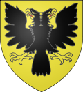 |
The arms of Mecquignies are blazoned : Or, a double headed eagle sable, beaked and membered Or, langued gules. (Louvroil and Mecquignies use the same arms.)
See also
edit
References edit
Wikimedia Commons has media related to Mecquignies.
|