


Summary
Melas Chasma /ˈmiːləs ˈkæzmə/ is a canyon on Mars, the widest segment of the Valles Marineris canyon system,[1] located east of Ius Chasma at 9.8°S, 283.6°E in Coprates quadrangle. It cuts through layered deposits that are thought to be sediments from an old lake that resulted from runoff of the valley networks to the west.[2] Other theories include windblown sediment deposits and volcanic ash.[1] Support for abundant, past water in Melas Chasma is the discovery by MRO of hydrated sulfates. In addition, sulfate and iron oxides were found by the same satellite.[3] Although not chosen as one of the finalists, it was one of eight potential landing sites for the Mars 2020 rover, a mission with a focus on astrobiology.
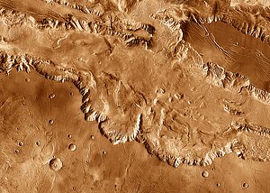 Melas Chasma in mosaic of THEMIS infrared images, with parts of Ius, Candor and Coprates chasmata visible at the upper left, top and lower right, respectively. Enormous landslide deposits are visible near the junctions of Melas Chasma with each of the neighboring chasmata. Numerous graben ("fossae") and ridges ("dorsa") stretch across the plateau outside the canyons' rims. | |
| Coordinates | 10°24′S 72°42′W / 10.4°S 72.7°W |
|---|---|
| Length | 547.0 km |
The floor of Melas Chasma is about 70% younger massive material that is thought to be volcanic ash whipped up by the wind into eolian features. It also contains rough floor material from the erosion of the canyon walls. Around the edges of Melas is also much slide material.[4]
In a recent study of southwestern Melas Chasma using high-resolution image, topographic and spectral datasets eleven fan-shaped landforms were found. These fans add to growing evidence that Melas Chasma once held a lake that had fluctuating levels.[5][6]
Using HiRISE images, CTX images, and DEM's, a team of researchers mapped many channels and inverted channels in Melas Chasma. A digital elevation model (DEM) is a digital model or 3D representation of a terrain's surface. In addition, they found dendritic networks of channels in the plateaus just above the Chasma. Channels appeared to have formed at different times, hence there were "wet-dry" phases in the history of Melas Chasma. The whole region may have had liquid water for extended periods in the early Hesperian.[7]
-
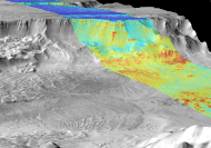 Combined infrared and daytime observation of Melas Chasma. The shadowed regions (blue) indicate successive landslides.
 -
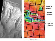 Cliff in Melas Chasma, as seen by THEMIS. Click on image to see relationship of Melas to other features.
 -
 Two views of Melas Chasma Layered Deposits, as seen by HiRISE. Left picture lies north of other picture on the right. Pictures are not the same scale. Click on image to see details of layers.
 -
 Layers in Monument Valley. These are accepted as being formed, at least in part, by water deposition. Since Mars contains similar layers, water remains as a major cause of layering on Mars.


See also edit
References edit
- ^ a b HiRISE | Eroding Layers in Melas Chasma (PSP_004054_1675)
- ^ HiRISE | MSL Landing Site in Melas Chasma (PSP_002828_1700)
- ^ Murchie, S. et al. 2009. "A synthesis of Martian aqueous mineralogy after 1 Mars year of observations from the Mars Reconnaissance Orbiter". Journal of Geophysical Research: 114.
- ^ Witbeck, Tanaka and Scott, Geologic Map of the Valles Marineris Region, Mars; USGS I-2010; 1991.
- ^ Williams, R.M.E.; Weitz, C.M. (2014). "Reconstructing the aqueous history within the southwestern Melas basin, Mars: Clues from stratigraphic and morphometric analyses of fans". Icarus. 242: 19–37. Bibcode:2014Icar..242...19W. doi:10.1016/j.icarus.2014.06.030.
- ^ Davis, J., P. Grindrod, R. Williams, S. Gupta, M. Balme. 2015. STRATIGRAPHIC EVIDENCE OF EPISODIC FLUVIAL ACTIVITY IN THE SOUTH MELAS CHASMA BASIN, VALLES MARINERIS, MARS. 46th Lunar and Planetary Science Conference. 1932.pdf
- ^ Davis, J., et al. 2017. FLUVIAL MAPPING AND STRATIGRAPHY OF THE SOUTH-WESTERN MELAS BASIN AND PLATEAU, VALLES MARINERIS, MARS: EPISODIC FLUVIAL PHASES AND IMPLICATIONS FOR CLIMATE. Lunar and Planetary Science XLVIII (2017). 1991.pdf
External links edit
- Metz, Joannah M.; John P. Grotzinger; David Mohrig; Ralph Milliken; Bradford Prather; Carlos Pirmez; Alfred S. McEwen & Catherine M. Weitz (2009). "Sublacustrine depositional fans in southwest Melas Chasma". Journal of Geophysical Research. 114 (E10002). Bibcode:2009JGRE..11410002M. doi:10.1029/2009JE003365.
- [1] Lakes on Mars - Nathalie Cabrol (SETI Talks)
- NASA Astronomy Picture of the Day: Melas, Candor and Ophir: Valleys of Mariner (17 February 2005)