
KNOWPIA
WELCOME TO KNOWPIA

Mesnil-Roc'h 
Summary
Mesnil-Roc'h (Breton: Sant-Pêr-Plewenn) is a commune in the Ille-et-Vilaine department in Brittany in northwestern France. It was established on 1 January 2019 by merger of the former communes of Saint-Pierre-de-Plesguen (the seat), Lanhélin and Tressé.[2]
Mesnil-Roc'h | |
|---|---|
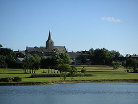 A general view of Saint-Pierre-de-Plesguen | |
Location of Mesnil-Roc'h .mw-parser-output .locmap .od{position:absolute}.mw-parser-output .locmap .id{position:absolute;line-height:0}.mw-parser-output .locmap .l0{font-size:0;position:absolute}.mw-parser-output .locmap .pv{line-height:110%;position:absolute;text-align:center}.mw-parser-output .locmap .pl{line-height:110%;position:absolute;top:-0.75em;text-align:right}.mw-parser-output .locmap .pr{line-height:110%;position:absolute;top:-0.75em;text-align:left}.mw-parser-output .locmap .pv>div{display:inline;padding:1px}.mw-parser-output .locmap .pl>div{display:inline;padding:1px;float:right}.mw-parser-output .locmap .pr>div{display:inline;padding:1px;float:left}html.skin-theme-clientpref-night .mw-parser-output .od,html.skin-theme-clientpref-night .mw-parser-output .od .pv>div,html.skin-theme-clientpref-night .mw-parser-output .od .pl>div,html.skin-theme-clientpref-night .mw-parser-output .od .pr>div{background:#000;color:#fff}html.skin-theme-clientpref-night .mw-parser-output .locmap{filter:grayscale(0.6)}@media(prefers-color-scheme:dark){html.skin-theme-clientpref-os .mw-parser-output .locmap{filter:grayscale(0.6)}html.skin-theme-clientpref-os .mw-parser-output .od,html.skin-theme-clientpref-os .mw-parser-output .od .pv>div,html.skin-theme-clientpref-os .mw-parser-output .od .pl>div,html.skin-theme-clientpref-os .mw-parser-output .od .pr>div{background:#000;color:#fff}}  Mesnil-Roc'h  Mesnil-Roc'h | |
| Coordinates: 48°26′52″N 1°54′43″W / 48.4478°N 1.9119°W | |
| Country | France |
| Region | Brittany |
| Department | Ille-et-Vilaine |
| Arrondissement | Saint-Malo |
| Canton | Combourg |
| Intercommunality | Bretagne Romantique |
| Area 1 | 41.16 km2 (15.89 sq mi) |
| Population (2021)[1] | 4,422 |
| • Density | 110/km2 (280/sq mi) |
| Time zone | UTC+01:00 (CET) |
| • Summer (DST) | UTC+02:00 (CEST) |
| INSEE/Postal code | 35308 /35720 |
| Elevation | 34–99 m (112–325 ft) |
| 1 French Land Register data, which excludes lakes, ponds, glaciers > 1 km2 (0.386 sq mi or 247 acres) and river estuaries. | |
Population edit
| Year | Pop. | ±% p.a. |
|---|---|---|
| 1968 | 3,009 | — |
| 1975 | 2,903 | −0.51% |
| 1982 | 2,960 | +0.28% |
| 1990 | 2,960 | +0.00% |
| 1999 | 2,848 | −0.43% |
| 2007 | 3,630 | +3.08% |
| 2012 | 4,047 | +2.20% |
| 2017 | 4,301 | +1.22% |
| Source: INSEE[3] | ||
See also edit
References edit
- ^ "Populations légales 2021". The National Institute of Statistics and Economic Studies. 28 December 2023.
- ^ Arrêté préfectoral 11 December 2018 (in French)
- ^ Population en historique depuis 1968, INSEE
Wikimedia Commons has media related to Mesnil-Roc'h.