


Summary
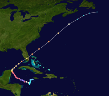
Hurricane Wilma was the most intense tropical cyclone in the Atlantic basin on record in terms of minimum barometric pressure, with an atmospheric pressure of 882 millibars (26.0 inHg). Wilma's destructive journey began in the second week of October 2005. A large area of disturbed weather developed across much of the Caribbean and gradually organized to the southeast of Jamaica. By late on October 15, the system was sufficiently organized for the National Hurricane Center to designate it as Tropical Depression Twenty-Four.
 Hurricane Wilma track map | |
| Meteorological history | |
|---|---|
| Formed | October 15, 2005 |
| Dissipated | October 26, 2005 |
| Category 5 major hurricane | |
| 1-minute sustained (SSHWS/NWS) | |
| Highest winds | 185 mph (295 km/h) |
| Lowest pressure | 882 mbar (hPa); 26.05 inHg (Record low in Atlantic) |
| Overall effects | |
| Areas affected | Hispaniola, Jamaica, Cuba, Cayman Islands, Central America, Southeast Mexico, East Coast of the United States (mainly in South Florida), Bahamas, Atlantic Canada, Europe |
Part of the 2005 Atlantic hurricane season | |
| History
Effects Other wikis
| |
The depression drifted southwestward, and under favorable conditions, it strengthened into Tropical Storm Wilma on October 17. Initially, development was slow due to its large size, though convection steadily organized. From October 18, and through the following day, Wilma underwent explosive deepening over the open waters of the Caribbean; in a 30-hour period, the system's central atmospheric pressure dropped from 982 millibars (29.0 inHg) to the record-low value of 882 millibars (26.0 inHg), while the winds increased to 185 mph (298 km/h). At its peak intensity, the eye of Wilma was about 2.3 miles (3.7 km) in diameter, the smallest known eye in an Atlantic hurricane. After the inner eye dissipated due to an eyewall replacement cycle, Hurricane Wilma weakened to Category 4 status, and on October 21, it made landfall on Cozumel and on the Mexican mainland with winds of about 150 mph (240 km/h).
Wilma weakened over the Yucatán Peninsula, and reached the southern Gulf of Mexico before accelerating northeastward. Despite increasing amounts of vertical wind shear, the hurricane re-strengthened to hit Cape Romano, Florida, as a major hurricane. Wilma weakened as it quickly crossed the state, and entered the Atlantic Ocean near Jupiter, Florida. The hurricane again re-intensified before cold air and wind shear penetrated the inner core of convection. By October 26, it transitioned into an extratropical cyclone, and the next day, the remnants of Wilma were absorbed by another extratropical storm over Atlantic Canada.
Formation edit

During the second week of October, an unusually large, monsoon-like lower-level circulation and a broad area of disturbed weather developed over much of the Caribbean Sea. The system was enhanced by diffluence from an upper-level low across the southwestern Atlantic.[1] By October 13, a broad area of low pressure developed and persisted about 150 miles (240 km) southeast of Jamaica,[2] possibly aided by the passage of tropical waves through the area at the time.[1] Convection increased and became slightly better organized, though upper-level wind shear initially prevented development. The system drifted westward, and early on October 14 the convection became more concentrated and a little better organized as upper-level wind shear lessened slightly.[2][3]
Later on October 14, the system became much better defined, with increasingly organized shower and thunderstorm activity, as conditions in the upper levels of the atmosphere became significantly more favorable. It was then that the National Hurricane Center first indicated that it was possible for a tropical depression to develop in the area.[4] Dvorak classifications were initiated on October 15.[1] The system continued to organize, with the National Hurricane Center remarking the system could ultimately become a hurricane.[5] By late on October 15, the surface circulation became defined well enough, with sufficiently organized deep convection, for the National Hurricane Center to designate the system as Tropical Depression Twenty-Four while it was located about 220 miles (350 km) east-southeast of Grand Cayman.[1]
The depression tracked slowly westward, a motion due to weak steering currents caused by a high-pressure area to its north across the Gulf of Mexico. Initially, the center of circulation was broad without a defined inner core; forecaster Lixion Avila remarked, "The area of minimum pressure could [have been] anywhere within 60 miles (97 km) of its [initial advisory position]." Initially, the tropical depression was forecast to drift west-southwestward before turning to the north; within five days of the forecast's issuance, the system was predicted to be located about 80 miles (130 km) south of the Isle of Youth as a 105 mph (169 km/h) hurricane. However, the National Hurricane Center noted in the first advisory on the depression that there were "all indications that there could a dangerous hurricane in the northwestern Caribbean Sea in 3 to 5 days." This was due to the depression being located within an environment very conducive for development, specifically low amounts of wind shear and very warm water temperatures.[6]
As Tropical Depression Twenty-Four drifted southwestward, it steadily organized; by early on October 16, rainbands began to gradually consolidate with well-established outflow, and a large upper-level anticyclone developed over the depression.[7] Although deep convection and banding features increased, mid-level dry air from the north prevented significant organization, and the convection was split into two primary areas. Surface buoy reports indicated that, due to its large size, the system failed to strengthen beyond tropical depression status, even though it received tropical storm strength Dvorak classifications from The National Hurricane Center's Tropical Analysis and Forecast Branch and the National Oceanic and Atmospheric Administration's Satellite Analysis Branch.[8] Continued reconnaissance flights reported peak winds of about 30 mph (48 km/h).[9]
Rapid intensification and peak strength edit

By early on October 17, the outer rainbands, which had previously dominated the structure of the cyclone, dissipated, while deep convection developed near and to the south of the center. Computer models predicted steady strengthening as the depression tracked westward before turning to the north. Of the intensity models, the Geophysical Fluid Dynamics Laboratory predicted an intensity of 135 mph (217 km/h) within 36 hours, with other forecasts being more conservative in their predictions.[10] Deep convection continued to develop to the south of the center, and the depression intensified into Tropical Storm Wilma at 0600 UTC on October 17, while located about 200 miles (320 km) southeast of Grand Cayman. Upon becoming a tropical storm, the National Hurricane Center predicted Wilma to track west-northwestward, reaching winds of 105 mph (169 km/h) before striking the northeastern portion of the Yucatán Peninsula.[11]
The storm continued to the southwest while deep convection persisted near the center. National Hurricane Center forecaster James Franklin remarked, "Confidence at the later ranges [of the forecast track] was unusually low", due to wide divergences between computer models.[12] Late on October 17, a hurricane hunters flight into Wilma recorded winds of 50 mph (80 km/h), but an unusually low pressure of 989 millibars (29.2 inHg), which would be more typical of a minimal hurricane. This was due to unusually low pressures across the region, which resulted in a lesser pressure gradient and thus lighter winds. Convection continued to develop near the center and became much more symmetrical.[13]

Tropical Storm Wilma began to turn to the west-northwest on October 18,[1] during which the storm developed a small, intermittent and ragged eye feature.[14] It continued to intensify, and at 1200 UTC on October 18, Wilma attained hurricane status while located about 225 miles (362 km) south-southeast of Grand Cayman.[1] Shortly after reaching hurricane strength, the hurricane began undergoing explosive deepening, after the development of a "pinhole" eye 9 miles (14 km) in diameter. This small eye was surrounded by a ring of deep convection, with cloud-top temperatures of about −125 °F (−87 °C).[15]
Early on October 19, Wilma attained major hurricane status while continuing to rapidly intensify, and by 0600 UTC, the storm's maximum sustained winds increased to 165 mph (266 km/h), making Wilma a dangerous Category 5 storm on the Saffir–Simpson scale.[1] In the span of just 24 hours, Wilma had intensified from a 70 mph (110 km/h) tropical storm to a 175 mph (282 km/h) Category 5 hurricane, an unprecedented event for an Atlantic hurricane.[1] The eye continued to contract to a diameter of about 2 nautical miles (3.7 km), the smallest known eye in an Atlantic hurricane, and at 1200 UTC on October 19, Wilma attained peak winds of 185 mph (298 km/h). The central pressure rapidly dropped 54 millibars (1.6 inHg) from 0000 to 0600 UTC, and at 0800 UTC, a hurricane hunters flight recorded a minimum central pressure of 884 millibars (26.1 inHg) in a dropsonde near the center of the extremely small eye. As the dropsonde did not reach the calm winds in the center, the pressure was estimated at 882 millibars (26.0 inHg), the lowest pressure in an Atlantic hurricane on record. The pressure continued to fall as the hurricane hunters left the hurricane, and it is possible the pressure was slightly lower.[1] Operationally, the peak intensity was estimated at 175 mph (282 km/h).[16] In 2019, Dr. Eric Uhlhorn of NOAA's Hurricane Research Division estimated that since the stepped-frequency microwave radiometer (SFMR) was not in use during Wilma but extrapolating from other high-end Category 5 hurricanes (such as Hurricane Felix of 2007), that the maximum sustained winds could have reached as high as 209 ± 20 mph (336 ± 32 km/h) following the Hurricane Hunter mission.[17] At the time of its peak intensity, hurricane-force winds extended only 50 miles (80 km) from the small center of Wilma, with tropical storm force winds extending only about 160 miles (260 km).[18]
First landfall edit

Shortly after peaking in intensity, the coldest cloud tops surrounding the eye warmed slightly and an outer eyewall began to develop, signifying an eyewall replacement cycle was occurring.[16] By late on October 19, the winds in Hurricane Wilma decreased to 160 mph (260 km/h) as the inner 5-mile (8 km) wide eye weakened and the wind field expanded.[19] Early on October 20 the hurricane weakened to Category 4 status after the small, inner eye dissipated and the 45-mile (72 km) wide outer eyewall became the dominant eye.[1] At the time, the pressure measured 892 millibars (26.3 inHg), the second-lowest known pressure for a Category 4 hurricane (Super Typhoon Judy had an 887 mb pressure at peak intensity), and Wilma retained the large eyewall as it turned northwestward.[1][20] Initially, the hurricane was forecast to re-intensify into a Category 5 hurricane,[21] with one forecast predicting it to make landfall on the Yucatán Peninsula with winds of 165 mph (266 km/h),[22] though Wilma remained a strong Category 4 hurricane as it tracked northwestward.[1]
Steering currents remained weak, though a series of troughs eroded the high-pressure system across the Gulf of Mexico, resulting in a turn towards the north-northwest. Environmental conditions remained favorable,[1] with the eye becoming more distinct early on October 21.[23] At about 2145 UTC on October 21, Wilma made landfall on the island of Cozumel with winds of 150 mph (240 km/h). It weakened slightly as it continued northwestward, and struck the Mexican mainland near Puerto Morelos, Quintana Roo, at 0330 UTC on October 22, with winds of 135 mph (217 km/h)[1] and gusts of up to 170 mph (270 km/h).[24]
Second landfall and demise edit
On October 22, the mid-level ridge to the north of Wilma essentially dissipated, leaving the hurricane drifting northward across the northeastern Yucatán Peninsula.[1] As the hurricane moved further inland, the eye became cloud-filled as the deepest convection began to warm, and the winds gradually weakened during its passage over land.[25] About 26 hours after making landfall on Cozumel, Wilma emerged into the southern Gulf of Mexico near Cabo Catoche with winds of about 100 mph (160 km/h).[26] Upon reaching open waters, reconnaissance aircraft reported the remains of an inner eyewall and an outer eyewall oscillating between 70 and 90 miles (110 and 140 km) in diameter. Convection deepened around the eyewalls,[27] and the inner core of convection, which had previously become disrupted over land, became slightly better defined.[28]

A powerful eastward-moving mid-level trough across the central United States turned the hurricane northeastward and caused it to gradually accelerate. Vertical wind shear increased as strong upper-level southwesterly flow increased, though in spite of the shear Wilma continued to intensify.[1] Early on October 24, Wilma attained major hurricane status while located about 120 miles (190 km) west-southwest of Key West, Florida. It gradually became better organized, with the large 50 miles (80 km) eye becoming very distinct on satellite and radar imagery. Wilma was able to retain its strength because large eyes in tropical cyclones are more stable and more resistant to vertical wind shear.[29] Despite wind shear values of about 30 mph (48 km/h), Wilma strengthened further to reach winds of 125 mph (201 km/h). It weakened slightly as it approached Florida, and made landfall at Cape Romano with winds of 120 mph (190 km/h) at around 1030 UTC on October 24.[1]
Hurricane Wilma crossed the Florida peninsula in about 4.5 hours while continuing to accelerate northeastward, and emerged into the Atlantic Ocean as a weakened 110 mph (180 km/h) hurricane near Jupiter. A vigorous cold front associated with the mid-level trough moved across the area to the west of Wilma, yet the cooler and drier air behind the front could not fully penetrate the inner core of the hurricane to weaken it. Shortly after exiting the Florida coastline, Wilma began to re-intensify,[1] believed to be due to a reduction of friction of the eyewall and warm waters of the Gulf Stream.[30] Early on October 25, the hurricane reached a secondary peak intensity of 125 mph (201 km/h) while located about 340 miles (550 km) east of Jacksonville, Florida.[1] During the time, the large circulation of Wilma absorbed the much smaller Tropical Depression Alpha over the Bahamas.[31]
Shortly after its secondary peak intensity, the wind shear, combined with its rapid forward motion of 50 mph (80 km/h), resulted in a steady weakening trend.[1] The overall cloud pattern began to deteriorate, with the eye becoming less distinct and the convection less symmetric.[32] By 1117 UTC on October 25, the center was located to the northwest of the primary convection as cold air from the southwest entrained the circulation.[33] The remaining convection continued to diminish, and by late on October 25 Wilma transitioned into an extratropical cyclone while located about 230 miles (370 km) southeast of Halifax, Nova Scotia, and still at Category 1 intensity. The weakening extratropical remnant turned to the east-northeast before being absorbed by another extratropical storm over Atlantic Canada on October 27.[1]
See also edit
References edit
- ^ a b c d e f g h i j k l m n o p q r s t u Richard J. Pasch; Eric S. Blake; Hugh D. Cobb III & David P. Roberts (2006-09-28). "Hurricane Wilma Tropical Cyclone Report" (PDF). National Hurricane Center. National Oceanic and Atmospheric Administration. Retrieved 2007-02-15.
- ^ a b Stacy R. Stewart (2005-10-13). "October 13 Tropical Weather Outlook 21z". National Hurricane Center. National Oceanic and Atmospheric Administration. Retrieved 2007-02-15.[dead link]
- ^ Stacy R. Stewart (2005-10-14). "October 14 Tropical Weather Outlook 09z". National Hurricane Center. National Oceanic and Atmospheric Administration. Retrieved 2007-02-15.[dead link]
- ^ Stacy R. Stewart (2005-10-14). "October 14 Tropical Weather Outlook 21z". National Hurricane Center. National Oceanic and Atmospheric Administration. Retrieved 2007-02-15.[dead link]
- ^ Lixion Avila (2005-10-15). "October 15 Tropical Weather Outlook 15z". National Hurricane Center. National Oceanic and Atmospheric Administration. Retrieved 2007-02-15.[dead link]
- ^ Lixion Avila (2005-10-15). "Tropical Depression Twenty-Four Discussion One". National Hurricane Center. National Oceanic and Atmospheric Administration. Retrieved 2007-02-16.
- ^ Richard Knabb (2005-10-15). "Tropical Depression Twenty-Four Discussion Two". National Hurricane Center. Retrieved 2007-02-16.
- ^ Stacy R. Stewart (2005-10-16). "Tropical Depression Twenty-Four Discussion Three". National Hurricane Center. National Oceanic and Atmospheric Administration. Retrieved 2007-02-16.
- ^ James Franklin (2005-10-16). "Tropical Depression Twenty-Four Discussion Five". National Hurricane Center. National Oceanic and Atmospheric Administration. Retrieved 2007-02-16.
- ^ Richard Knabb (2005-10-16). "Tropical Depression Twenty-Four Discussion Six". National Hurricane Center. National Oceanic and Atmospheric Administration. Retrieved 2007-02-16.
- ^ Stacy R. Stewart (2005-10-17). "Tropical Storm Wilma Discussion Seven". National Hurricane Center. National Oceanic and Atmospheric Administration. Retrieved 2007-02-16.
- ^ James Franklin (2005-10-17). "Tropical Storm Wilma Discussion Eight". National Hurricane Center. National Oceanic and Atmospheric Administration. Retrieved 2007-02-16.
- ^ James Franklin (2005-10-17). "Tropical Storm Wilma Discussion Nine". National Hurricane Center. National Hurricane Center. Retrieved 2007-02-16.
- ^ Richard Knabb (2005-10-17). "Tropical Storm Wilma Discussion Ten". National Hurricane Center. National Oceanic and Atmospheric Administration. Retrieved 2007-02-16.
- ^ Jack Beven (2005-10-18). "Hurricane Wilma Discussion Fourteen". National Hurricane Center. National Oceanic and Atmospheric Administration. Retrieved 2007-02-16.
- ^ a b James Franklin (2005-10-19). "Hurricane Wilma Discussion Seventeen". National Hurricane Center. National Oceanic and Atmospheric Administration. Retrieved 2007-02-16.
- ^ Masters, Jeff. "Did Hurricane Wilma have 209 mph sustained winds?". Weather Underground. Retrieved 21 September 2019.
- ^ James Franklin (2005-10-19). "Hurricane Wilma Public Advisory Seventeen". National Hurricane Center. National Oceanic and Atmospheric Administration. Retrieved 2007-02-17.
- ^ James Franklin (2005-10-19). "Hurricane Wilma Discussion Eighteen". National Hurricane Center. National Oceanic and Atmospheric Administration. Retrieved 2007-02-16.
- ^ "Atlantic hurricane best track (HURDAT version 2)" (Database). United States National Hurricane Center. April 5, 2023. Retrieved April 19, 2024.
 This article incorporates text from this source, which is in the public domain.
- ^ Lixion Avila (2005-10-20). "Hurricane Wilma Discussion Twenty". National Hurricane Center. National Oceanic and Atmospheric Administration. Retrieved 2007-02-17.
- ^ James Franklin (2005-10-20). "Hurricane Wilma Discussion Twenty-Two". National Hurricane Center. National Oceanic and Atmospheric Administration. Retrieved 2007-02-17.
- ^ Lixion Avila (2005-10-21). "Hurricane Wilma Discussion Twenty-Four". National Hurricane Center. Retrieved 2007-02-17.
- ^ Michel Rosengaus & Alberto Hernández Unzón (2006-07-19). "Resúmen de la temporada de ciclones tropicales 2005, 1ra parte" (PDF) (in Spanish). Servicio Meteorológico Nacional (Mexico), Comisión Nacional del Agua. Archived from the original (PDF) on 2007-06-25. Retrieved 2007-02-19.
- ^ Jack Beven (2005-10-21). "Hurricane Wilma Discussion Twenty-Seven". National Hurricane Center. National Oceanic and Atmospheric Administration. Retrieved 2007-02-17.
- ^ Alberto Hernández Unzón & M.G. Cirilo Bravo (2006). "Resúmen del Huracán "Wilma" del Océano Atlántico" (PDF) (in Spanish). Servicio Meteorológico Nacional, Comisión Nacional del Agua. Archived from the original (PDF) on 2012-02-27. Retrieved 2007-02-19.
- ^ Jack Beven (2005-10-22). "Hurricane Wilma Discussion Thirty-One". National Hurricane Center. National Oceanic and Atmospheric Administration. Retrieved 2007-02-17.
- ^ Richard J. Pasch (2005-10-23). "Hurricane Wilma Discussion Thirty-Two". National Hurricane Center. National Oceanic and Atmospheric Administration. Retrieved 2007-02-17.
- ^ Stacy R. Stewart (2005-10-23). "Hurricane Wilma Discussion Thirty-Five". National Hurricane Center. National Oceanic and Atmospheric Administration. Retrieved 2007-02-17.
- ^ Richard Knabb (2005-10-24). "Hurricane Wilma Special Discussion Thirty-Eight". National Hurricane Center. National Oceanic and Atmospheric Administration. Retrieved 2007-02-17.
- ^ Lixion Avila (2006-01-04). "Tropical Storm Alpha Tropical Cyclone Report" (PDF). National Hurricane Center. National Oceanic and Atmospheric Administration. Retrieved 2007-02-17.
- ^ James Franklin (2005-10-25). "Hurricane Wilma Discussion Forty-One". National Hurricane Center. National Oceanic and Atmospheric Administration. Retrieved 2007-02-17.
- ^ Jack Beven (2005-10-25). "Hurricane Wilma Discussion Forty-Two". National Hurricane Center. National Oceanic and Atmospheric Administration. Retrieved 2007-02-17.