
KNOWPIA
WELCOME TO KNOWPIA

Mianeh County (Iran) 
Summary
Mianeh County (Persian: شهرستان میانه),[3] also Romanized as Miyaneh County, is in East Azerbaijan province, Iran. Its capital is the city of Mianeh.[4]
Mianeh County
Persian: شهرستان میانه | |
|---|---|
County | |
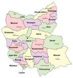 Location of Mianeh County in East Azerbaijan province (bottom right, yellow) | |
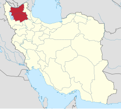 Location of East Azerbaijan province in Iran | |
| Coordinates: 37°29′N 47°48′E / 37.483°N 47.800°E[1] | |
| Country | |
| Province | East Azerbaijan |
| Capital | Mianeh |
| Districts | Central, Kaghazkonan, Kandovan, Torkamanchay |
| Population (2016)[2] | |
| • Total | 182,848 |
| Time zone | UTC+3:30 (IRST) |
| Mianeh County (Iran) can be found at GEOnet Names Server, at this link, by opening the Advanced Search box, entering "9205880" in the "Unique Feature Id" form, and clicking on "Search Database". | |
At the 2006 census, the county's population was 187,870 in 46,469 households.[5] The following census in 2011 counted 185,806 people in 52,630 households.[6] At the 2016 census, the county's population was 182,848 in 57,665 households.[2] The city of Torkamanchay is where the Treaty of Turkmenchay was signed by Russia and Iran in 1828.
Administrative divisions edit
The population history and structural changes of Mianeh County's administrative divisions over three consecutive censuses are shown in the following table. The latest census shows four districts, 17 rural districts, and five cities.[2]
| Administrative Divisions | 2006[5] | 2011[6] | 2016[2] |
|---|---|---|---|
| Central District | 126,668 | 130,079 | 129,600 |
| Garmeh-ye Jonubi RD | 8,205 | 6,331 | 5,394 |
| Kolah Boz-e Gharbi RD | 5,121 | 4,107 | 3,553 |
| Kolah Boz-e Sharqi RD | 5,825 | 5,209 | 4,402 |
| Owch Tappeh-ye Sharqi RD | 2,636 | 2,026 | 1,843 |
| Qaflankuh-e Gharbi RD | 12,166 | 11,920 | 7,372 |
| Qezel Uzan RD | 2,958 | 2,673 | 2,617 |
| Sheykhdarabad RD | 2,372 | 2,308 | 1,799 |
| Achachi (city) | 3,647 | ||
| Mianeh (city) | 87,385 | 95,505 | 98,973 |
| Kaghazkonan District | 11,101 | 9,366 | 10,729 |
| Kaghazkonan-e Markazi RD | 2,186 | 1,930 | 2,038 |
| Kaghazkonan-e Shomali RD | 3,818 | 2,959 | 3,216 |
| Qaflankuh-e Sharqi RD | 3,274 | 2,744 | 2,573 |
| Aqkand (city) | 1,823 | 1,733 | 2,902 |
| Kandovan District | 24,820 | 23,637 | 21,131 |
| Garmeh-ye Shomali RD | 7,584 | 6,645 | 5,446 |
| Kandovan RD | 8,444 | 8,487 | 7,857 |
| Tirchai RD | 6,923 | 6,099 | 5,797 |
| Tark (city) | 1,869 | 2,406 | 2,031 |
| Torkamanchay District | 25,281 | 22,724 | 21,387 |
| Barvanan-e Gharbi RD | 5,679 | 4,472 | 4,132 |
| Barvanan-e Markazi RD | 2,174 | 1,606 | 1,721 |
| Barvanan-e Sharqi RD | 8,304 | 7,400 | 6,356 |
| Owch Tappeh-ye Gharbi RD | 2,690 | 2,152 | 1,735 |
| Torkamanchay (city) | 6,434 | 7,094 | 7,443 |
| Total | 187,870 | 185,806 | 182,848 |
| RD: Rural District | |||
Wikimedia Commons has media related to Mianeh County.
References edit
- ^ OpenStreetMap contributors (24 February 2024). "Mianeh County" (Map). OpenStreetMap. Retrieved 24 February 2024.
- ^ a b c d "Census of the Islamic Republic of Iran, 1395 (2016)". AMAR (in Persian). The Statistical Center of Iran. p. 03. Archived from the original (Excel) on 13 November 2020. Retrieved 19 December 2022.
- ^ BGN Standard without diacritics. "Geonames" Archived 2008-05-22 at the Wayback Machine United States National Geospatial-Intelligence Agency (NGA)
- ^ Habibi, Hassan (21 June 1369). "Approval of the organization and chain of citizenship of the elements and units of the country's divisions of East Azerbaijan province, centered in the city of Tabriz". Qavanin (in Persian). Political-Defense Commission of the Government Board. Archived from the original on 23 October 2021. Retrieved 5 December 2023.
- ^ a b "Census of the Islamic Republic of Iran, 1385 (2006)". AMAR (in Persian). The Statistical Center of Iran. p. 03. Archived from the original (Excel) on 20 September 2011. Retrieved 25 September 2022.
- ^ a b "Census of the Islamic Republic of Iran, 1390 (2011)". Syracuse University (in Persian). The Statistical Center of Iran. p. 03. Archived from the original (Excel) on 16 January 2023. Retrieved 19 December 2022.