


Summary
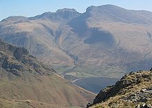
Mickledore (the name means great door or pass) is a narrow ridge, 840 metres (2755 ft) high, connecting the mountains of Scafell and Scafell Pike in the English Lake District. It is also a pass between the valleys of Wasdale and Eskdale.
Ridge edit
The ridge is easily reached and traversed from Scafell Pike to the north, or from the valleys to the east and west. However, access to the summit of Scafell is barred by the rockface of Broad Stand, which looks much easier to climb than it is.
Broad Stand edit
Broad Stand is a steep buttress wall requiring sequential bouldering moves, which have been described as anything from scrambling to rock climbing. It is described as 'extremely dangerous' by Wasdale Mountain Rescue Team,[1] and the climb is "Difficult" in the British grading system.[2] In descent, the cliff is even more dangerous.
The poet Samuel Taylor Coleridge probably made a descent of Broad Stand on 5 August 1802; he wrote:

- . . ."I began to suspect that I ought not to go on, but then unfortunately tho' I could with ease drop down a smooth Rock 7 feet (2.1 m) high, I could not climb it, so go on I must and on I went. The next 3 drops were not half a Foot, at least not a foot more than my own height, but every Drop increased the Palsy of my Limbs — I shook all over, Heaven knows without the least influence of Fear, and now I had only two more to drop down, to return was impossible — but of these two the first was tremendous, it was twice my own height, and the Ledge at the bottom was so exceedingly narrow, that if I dropt down upon it I must of necessity have fallen backwards and of course killed myself. My Limbs were all in a tremble — I lay upon my Back to rest myself, and was beginning according to my Custom to laugh at myself for a Madman, when the sight of the Crags above me on each side, and the impetuous Clouds just over them, posting so luridly and so rapidly northward, overawed me. I lay in a state of almost prophetic Trance and Delight — and blessed God aloud, for the powers of Reason and the Will, which remaining no Danger can overpower us! [3]
— Samuel Taylor Coleridge (1772–1834)
The historian and outdoor enthusiast W. G. Collingwood wrote the following in his classic guide book The Lake Counties:
. . ."Indeed, it stands up with pinnacles and buttresses so high, and flanking precipice's so deep, and even in places overhanging, that here, if anywhere in these mountains, one can get the impression of size and awesomeness. . .Right in front of Mickledore ridge the blocky volcanic-ash formation cleaves into a set of gigantic steps, as it were tilted from behind, so that the top of each step slopes outwards, and what should be vertical overhangs[a]. . .That is the Broad Stand. . .[4]
— W. G. Collingwood (1854–1932)
Route to Scafell edit
The walker seeking a safe route between England's highest mountains must go via Foxes Tarn, which involves a descent to 680 m or so, about 160 m below the height of the ridge. The more challenging routes of Lord's Rake, and the West Wall Traverse, offer alternative ways to reach Scafell.
Route to Scafell via Foxes Tarn edit
From the Mickledore ridge it is necessary to descend on the south side to pick up the path to Foxes Tarn. Older OS maps show the path junction near the confluence of two streams at about 680m, however later maps show the path junction lower down at about 650m. It is possible that the old path has been replaced with a newer one.
| Name | Height | Descent | Ascent | OS Grid[b][c] | Notes |
|---|---|---|---|---|---|
| Scafell Pike | 978m | 0 | 0 | NY 215 072 | Highest peak in England |
| Mickledore col | 840m | 138m | 0 | NY 209 069 | |
| Path junction | 650m | 190m | 0 | NY 212 065 | The path to Foxes Tarn |
| Foxes Tarn | 820m | 0 | 170m | NY 209 064 | |
| Scafell | 964m | 0 | 144m | NY 207 065 | Second highest peak in England |
| 328m | 314m | Height difference 14m |
History edit
Rescue box 1974 edit

The Mickledore mountain rescue stretcher box was airlifted to the site by the crew of an RAF helicopter in 1974.[d]
..."In 1974, Flt Lt John Nowell and his crew - Fg Off Lex Brown and crewman, Sgt Brian Gladwell of Number 230 Squadron RAF, RV'd with a party of students from the Eskdale Outward Bound School near Wasdale head pub. A party of about 10 students were first flown to Mickledore. The help returned to the RV point and the MRT 'Box' was loaded crosswise into the help with the ends sticking out. The box was flown back to Mickledore where the 1st party manhandled the box out of the help - which only had the nose wheel in contact with the ridge. The help then went back to the RV point, collected the remaining chaps and landed up towards Scafell Pike on a patch of flatfish ground and shut down. The box was manoeuvred into position and once it was deemed secure, the crew flew everyone back to Eskdale School. A 10-minute film shot that day showing the help emerging from the clouds to land on the ridge where the box was extracted was shown in its entirety of the 6 o'clock ITV news. The photographs taken that day were published in the book A Day Above The Lake District[6] The book contains a specially written amusing poem by Pam Ayers to be the Foreword to the book.
— John J. Nowell BA(Hons) Cfs FRGS LRPS RAF (Flt Lt Retired) – 13 December 2022
See also edit
References edit
- ^ "Broad Stand – There is no easy route direct from Scafell to Scafell Pike! » Wasdale Mountain Rescue".
- ^ A. Phizacklea (1996), Scafell, Wasdale & Eskdale, Fell and Rock Climbing Club of the English Lake District.
- ^ Samuel Taylor Coleridge (1802), letter to Sara Hutchinson.
- ^ Collingwood & Rollinson 1988, pp. 62.
- ^ *"Scafell Pike rescue stretcher box contents found strewn across mountainside". www.grough.co.uk. Retrieved 3 December 2023.
- ^ Nowell 2013, pp. 0.
Notes edit
- ^ See Scafell Pike > Etymology > ..."to jut out”...
- ^ Note that Defra's MAGIC service is available from the GeoHack panel.
- ^ MAGiC MaP – Help
- Amend scale to 1:5,000 to show footpaths
- Use Table of Contents for Colour mapping.
- ^ News article posted August 2015..."The Mickledore box was airlifted to the site by the crew of an RAF helicopter..."
See comment by John Nowell dated 12 December 2022
..."I was the pilot of that RAF Puma helicopter long ago in 1974...[5]
Sources edit
- Collingwood, W. G.; Rollinson, William (1988). The Lake Counties (1932); Revised by William Rollinson (1988). J.M. Dent & Sons. ISBN 0-460-04758-2.
- Nowell, John (2013). A Day Above The Lake District. Zodiac Publishing UK Ltd. ISBN 978-1904566144.
54°27′05″N 3°13′11″W / 54.45139°N 3.21972°W