
KNOWPIA
WELCOME TO KNOWPIA

Mildred Island 
Summary
Mildred Island is a submerged island in the San Joaquin River delta, in California.[2][3] It is part of San Joaquin County. It flooded in 1983, and the land was abandoned.[4] Its coordinates are 37°59′11″N 121°31′23″W / 37.9863117°N 121.5230069°W[1]. It appears on 1913 and 1952 United States Geological Survey maps of the area.[5][6]
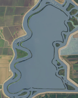 USGS aerial imagery of Mildred Island; the only part that remains above water is its levees. | |
 Mildred Island  Mildred Island  Mildred Island | |
| Geography | |
|---|---|
| Location | Northern California |
| Coordinates | 37°59′11″N 121°31′23″W / 37.9863117°N 121.5230069°W[1] |
| Adjacent to | Sacramento–San Joaquin River Delta |
| Administration | |
| State | |
| County | San Joaquin |

References edit
- ^ a b U.S. Geological Survey Geographic Names Information System: Mildred Island
- ^ "Delta/Stockton". The Fresno Bee. Fresno, California. 2006-08-30. p. D5.
- ^ "Fish Report, Delta/Stockton". The Modesto Bee. Modesto, California. 2019-12-04. p. B5.
- ^ | url = https://californiawaterblog.com/2013/06/17/the-delta-wont-rise-again/
- ^ Marshall, R.B.; Gerdine, T.G.; Hannegan, Duncan; Lewis, J.L. (1913). "Topography, State of California: Woodward Island Quadrangle". United States Geological Survey. Archived from the original on 5 April 2020. Retrieved 25 February 2021.
- ^ United States Geological Survey (1952). "Woodward Island Quadrangle, California" (Map). United States Department of the Interior Geological Survey. 1:24000.