


Summary
Minahasa Regency is a regency in North Sulawesi, Indonesia. Its capital is Tondano. It covers an area of 1,141.64 km2 and had a population of 310,384 at the 2010 Census;[3] this rose to 347,290 at the 2020 Census,[4] and the official estimate as at mid 2022 was 350,317.[2]
Minahasa Regency
(Kabupaten Minahasa) | |
|---|---|
 Coat of arms | |
 Location in North Sulawesi | |
 Minahasa Regency Location in Indonesia | |
| Coordinates: 1°1′N 124°34′E / 1.017°N 124.567°E | |
| Country | Indonesia |
| Province | North Sulawesi |
| Established | 5 November 1428 |
| Capital | Tondano |
| Government | |
| • Regent | Royke Roring |
| • Vice Regent | Robby Dondokambey |
| Area | |
| • Total | 1,025.85 km2 (396.08 sq mi) |
| Population (mid 2022 estimate)[2] | |
| • Total | 350,317 |
| • Density | 340/km2 (880/sq mi) |
| Time zone | UTC+8 (WITA) |
| Website | minahasa.go.id |
Several cities and regencies representing areas that were initially part of the Minahasa Regency have since been removed from this regency and established as the cities of Bitung (1975, initially as an administrative city)[5] and Tomohon (2003),[6] and the regencies of South Minahasa (2003),[6] North Minahasa (2003),[7] and Southeast Minahasa (2007, through the South Minahasa Regency).[8]
History edit
In 1983, Minahasa Regency government declared 5 November 1428 as the anniversary of the regency. This date is purely symbolic, because the day and month were taken from the day and month of Sam Ratulangi's birth date, Ratulangi being one of the most prominent historical figures from Minahasa. The year 1428 symbolizes the estimated year of the meeting of the Minahasan tribes who came together in their resistance to the neighboring Bolaang Mongondow Kingdom. Because it is only an approximation, the numbers of the year 1428 were taken from two important events, which are Peristiwa Merah Putih (or the Red and White Incident) that occurred in Manado on 14 February 1946, and the Second Youth Congress which produced the Youth Pledge that was held in 1928. The number 14 comes from the day the Red and White Incident occurred, while the number 28 is taken from the year when the Second Youth Congress was held.[9]
The Minahasa region itself was designated as an administrative region as a kabupaten (or regency) in 1965 based on Indonesian Law No. 18/1965. In this law, the administrative regions of the Province of North Sulawesi that were formerly called Daerah Tingkat II (or Level II Region) were now called Kabupaten. Hence, Daerah Tingkat II Minahasa became Kabupaten Minahasa.[10]: 158 The existence of the region that includes the current Minahasa Regency as an administrative region can be seen long before the issuance of the 1965 law and before the formation of the Republic of Indonesia.
Agreement with VOC edit
In addition to banding together to fight pressure from outside in the 15th century, the tribes in Minahasa also came together in the 17th century to do a similar thing. Several Minahasa tribes joined in a friendship agreement with the Vereenigde Oostindische Compagnie (VOC or the Dutch East Indies Company). The intention was the same, that is to combat attacks from the Bolaang area. This agreement became official on 10 January 1679 during the visit of Robertus Padtbrugge who was the VOC governor based in Maluku at that time. There are 23 chiefs of political and social communities called walak who participated in the agreement. The chiefs came from Aris, Bantik, Kakaskasen, Klabat, Klabat, Klabat Atas, Langowan, Pasan (who also represented Pinosokan and Ratahan), Remboken, Rumoong, Sarongsong, Tombariri, Tombasian, Tomohon, Tompaso, Tondano, Tonkimbut Atas, Tonkimbut, Tonkimbut Below, Tonsawang, and Tonsea.[11]: 24
Dutch occupation edit
The area encompassing the current Minahasa Regency has been designated as an official administrative region since the Dutch occupation after the VOC was dissolved when Indonesia was called the Dutch East Indies. At the time, the Residentie Manado (or Residency of Manado) covered all regencies and cities in entire region of Minahasa today, namely the regencies of Minahasa, North Minahasa, South Minahasa, Southeast Minahasa, and the cities of Bitung, Manado, and Tomohon. In 1856, the walak communities in Minahasa were organized into 26 districts. At the end of the 19th century, the number of districts fell to 18, namely Bantik, Kakaskasen, Kakas-Remboken, Kawangkoan, Langowan, Manado, Maumbi, Pasan Ratahan-Pinosakan, Rumoong, Sonder, Tombariri, Tombasian, Tomohon-Sarongsong, Tompaso, Tondano-Touliang, Tondano-Toulimambot, Tonsawang, and Tonsea. Then in 1908, the number dropped to 16, where the Kakaskasen District was abolished and the Rumoong and Tombasian districts were combined. The number of districts were cut down to seven in 1920 with the remaining districts being Amurang, Kawangkoan, Manado, Ratahan, Tomohon, Tonsea, and Toulour. In 1927, Manado and Tomohon were combined so that only six districts remained: Amurang, Kawangkoan, Manado, Ratahan, Tonsea, and Toulour. Arrangements of these districts lasted until the arrival and occupation of Japan.[10]: 127 Under these six districts, an administrative region called the onderdistrict (or subdistrict) was designated. There were 16 subdistricts at that time named Airmadidi, Amurang, Eris, Kakas, Kauditan, Kawangkoan, Langowan, South Manado, North Manado, Ratahan, Tatelu, Tenga, Tombariri, Tombatu, Tomohon, Tompaso, Tondano, and Tumpaan.[12]: 156
For administrative region above the district level, the Minahasa region in the Manado Residency was part of the Manado Afdeeling, which was formed in 1911. This administrative region was further divided into three areas: Amurang, Manado, and Tondano. Before the formation of the Manado Afdeeling, there were five onderafdeeling covering the area of Minahasa, namely Amurang, Belang, Kema, Manado and Tondano. In 1926, these onderafdeeling were abolished.[10]: 127
Japanese occupation edit
During the years of the Japanese occupation, the organization of administrative regions did not change much. In 1942, the number of districts increased by one where the Toulour District was divided into the districts of Langowan and Tondano. In the same year, the Manado District was divided into the districts of Manado and Tomohon.[10]: 132 In 1943, the separation of the city of Manado from the other areas of Minahasa can be seen happening for the first time where the Minahasa region sans Manado were united and given the name Minahasa-ken.[10]: 134
Republic of Indonesia edit
After Indonesian independence, the Minahasa region was included in the Province of Sulawesi and the residency based in Manado.[10]: 153 [13] Then for a short time, the region was included in the territory of the State of East Indonesia as one of its 13 administrative regions.[14] In 1953, Manado was designated as a municipality with the status of second level region (or Daerah Tingkat II) with the province designated as the first level region. Manado again became separated from the other Minahasa areas. Due to this separation, the capital of the Minahasa region was later changed from Manado to Tondano in 1959.[10]: 157–158
In 1960, the Province of Sulawesi was divided into the provinces of North Sulawesi and South Sulawesi based on Indonesian Regulation No. 5/1960. The names of these two provinces were changed according to Indonesian Law No. 47/1960, where the Province of North Sulawesi became the Province of North-Central Sulawesi. The region of Minahasa as a second level region was included in this province. Then in 1964, the Province of North-Central Sulawesi was further divided into the provinces of North Sulawesi and Central Sulawesi based on Indonesian Law No. 13/1964. Minahasa as a second level region was included in the province of North Sulawesi. The use of the name of the kabupaten was given based on Indonesian Law No. 18/1965, in which the Daerah Tingkat II Minahasa became Kabupaten Minahasa. Then based on Indonesian Law No. 5/1974, the name was changed again to Daerah Tingkat II Kabupaten Minahasa.[10]: 159 The list of districts under the regency at that time were Airmadidi, Belang, Bitung, Dimembe, Eris, Kakas, Kauditan, Kawangkoan, Kombi, Likupang, Modoinding, Motoling, Pineleng, Ratahan, Remboken, Sonder, Tareran, Tenga, Tombariri, Tombasian, Tombatu, Tomohon, Tompaso, Tompaso Baru, Tondano, Tumpaan, and Wori.[10]: 161–162
In the following years, the regency underwent several changes with the formation of new administrative regions from within the territory of the regency itself. Based on Indonesian Regulation No. 4/1975, the Bitung Administrative Municipality was inaugurated as a separate administrative region from the Minahasa Regency. On 25 February 2003, the Minahasa Regency was divided into the Minahasa Regency, the South Minahasa Regency, and the Municipality of Tomohon based on Indonesian Law No. 10/2003. Then on 18 December 2003, the residual Minahasa Regency was further divided into the Minahasa Regency and the North Minahasa Regency based on Indonesian Law No. 33/2005.
Administrative districts edit
The regency is divided into twenty-five districts (kecamatan), tabulated below with their areas and population totals from the 2010 Census[3] and the 2020 Census,[4] together with the official estimates as at mid 2022.[2] It includes the six new districts of Kakas Barat, Kawangkoan Barat, Kawangkoan Utara, Mandolang, Tombariri Timur, and Tompaso Barat, which were established after 2010. The table also includes the locations of the administrative centres, the number of administrative villages in each district (totaling 227 rural desa and 43 urban kelurahan), and its postal codes.
| Kode Wilayah |
Name of District (kecamatan) |
English name | Area in km2 |
Pop'n Census 2010 |
Pop'n Census 2020 |
Pop'n Estimate mid 2022 |
Admin centre |
No. of villages |
Post codes |
|---|---|---|---|---|---|---|---|---|---|
| 71.02.09 | Langowan Timur | (East Langowan) | 7.24 | 12,220 | 13,571 | 13,639 | Waleure | 8 | 95696 |
| 71.02.10 | Langowan Barat | (West Langowan) | 42.69 | 15,143 | 16,613 | 16,657 | Raranon | 16 | 95694 |
| 71.02.17 | Langowan Selatan | (South Langowan) | 69.65 | 7,457 | 8,094 | 8,099 | Winebetan | 10 | 95695 |
| 71.02.19 | Langowan Utara | (North Langowan) | 8.27 | 7,990 | 8,754 | 8,775 | Tempang Dua | 8 | 95697 |
| 71.02.07 | Tompaso | 17.32 | 15,158 | 7,447 | 7,475 | Liba | 10 | 95693 | |
| 71.02.25 | Tompaso Barat | (West Tompaso) | 14.61 | (a) | 9,276 | 9,311 | Pinaesaan | 10 | 95698 |
| 71.02.12 | Kawangkoan | 35.99 | 25,904 | 10,500 | 10,517 | Sendangan Tengah | 10 (b) | 95690 | |
| 71.02.22 | Kawangkoan Barat | (West Kawangkoan) | 13.09 | (c) | 8,721 | 8,735 | Kayuuwi Satu | 10 | 95692 |
| 71.02.21 | Kawangkoan Utara | (North Kawangkoan) | 19.27 | (c) | 9,037 | 9,051 | Kiawa Dua Timur | 10 (d) | 95699 |
| 71.02.11 | Sonder | 52.52 | 17,503 | 19,538 | 19,656 | Talikuran | 19 | 95691 | |
| 71.02.15 | Tombariri | 56.43 | 25,651 | 18,200 | 18,306 | Borgo | 10 | 95651 | |
| 71.02.24 | Tombariri Timur | (East Tombariri) | 101.57 | (e) | 10,404 | 10,465 | Lolah Tiga | 10 | 95652 |
| 71.02.13 | Pineleng | 49.30 | 45,079 | 30,306 | 30,680 | Pineleng Dua | 14 | 95662 | |
| 71.02.14 | Tombulu | 73.43 | 15,023 | 19,310 | 19,964 | Kembes Satu | 11 | 95663 | |
| 71.02.23 | Mandolang | 47.05 | (f) | 21,658 | 21,925 | Tateli Tiga | 12 | 95661 | |
| 71.02.01 | Tondano Barat | (West Tondano) | 22.66 | 18,862 | 21,558 | 21,787 | Rinegetan | 9 (g) | 95616 -95617 |
| 71.02.18 | Tondano Selatan | (South Tondano) | 25.34 | 19,716 | 17,906 | 17,918 | Tataaran Patar | 8 (g) | 95618 -95619 |
| 71.02.02 | Tondano Timur | (East Tondano) | 33.71 | 13,772 | 15,092 | 15,129 | Ranowangko | 11 (g) | 95611 -95615 |
| 71.02.16 | Tondano Utara | (North Tondano) | 63.49 | 11,211 | 13,030 | 13,211 | Tonsea Lama | 8 (h) | 95614 -95615 (i) |
| 71.02.08 | Remboken | 24.07 | 10,994 | 12,770 | 12,946 | Talikuran | 11 | 95681 | |
| 71.02.06 | Kakas | 88.85 | 21,211 | 12,646 | 12,716 | Pahaleten | 13 | 95680 | |
| 71.02.20 | Kakas Barat | (West Kakas) | 45.16 | (j) | 10,974 | 11,035 | Wasian | 10 | 95682 |
| 71.02.05 | Lembean Timur | (East Lembean) | 76.94 | 7,523 | 8,459 | 8,522 | Kapataran | 11 | 95685 |
| 71.02.03 | Eris | 33.25 | 9,932 | 11,964 | 12,215 | Eris | 8 | 95683 | |
| 71.02.04 | Kombi | 119.74 | 10,035 | 11,462 | 11,583 | Kombi | 13 | 95684 | |
| Totals | 1,141.64 | 310,384 | 347,290 | 350,317 | 270 |
Notes: (a) the 2010 population of the new Tompaso Barat District is included in the 2010 figure for Tompaso District, from which it was split off in 2012. (b) including 6 kelurahan.
(c) the 2010 populations of the new Kawangkoan Utara and Kawangkoan Barat Districts are included in the 2010 figure for Kawangkoan District, from which they were later split off.
(d) including 4 kelurahan. (e) the 2010 population of the new Tombariri Timur District is included in the 2010 figure for Tombariri District, from which it was split off in 2012.
(f) the 2010 population of the new Mandolang District is included in the 2010 figure for Pineleng District, from which it was split off in 2012. (g) all are kelurahan. (h) including 5 kelurahan.
(i) except the village of Tonsea Lama, which has a post code of 95610. (j) the 2010 population of the new Kakas Barat District is included in the 2010 figure for Kakas District, from which it was split off later in 2010.
-
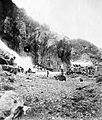 Gold mining in the Totok Minahasa Celebes gold mine

See also edit
References edit
- ^ North Sulawesi in Figures 2014. Badan Pusat Statistik Sulawesi Utara, 2014.
- ^ a b c Badan Pusat Statistik, Jakarta, 2023, Kabupaten Minahasa Dalam Angka 2023 (Katalog-BPS 1102001.7102)
- ^ a b Biro Pusat Statistik, Jakarta, 2011.
- ^ a b Badan Pusat Statistik, Jakarta, 2021.
- ^ Peraturan Pemerintah Republik Indonesia Nomor 4 Tahun 1975
- ^ a b Undang-Undang Republik Indonesia Nomor 10 Tahun 2003 Archived 2009-11-24 at the Wayback Machine
- ^ Undang-Undang Republik Indonesia Nomor 33 Tahun 2003 Archived 2009-11-23 at the Wayback Machine
- ^ Undang-Undang Republik Indonesia Nomor 9 Tahun 2007 Archived 2012-01-07 at the Wayback Machine
- ^ Talumewo, Bodewyn (2013-02-27). "Sejarah Penetapan Hari Jadi Minahasa" [History of the Designation of the Anniversary of Minahasa] (in Indonesian). Berita Manado. Retrieved 2020-06-03.
- ^ a b c d e f g h i Sejarah Daerah Sulawesi Utara [The History of the Region of North Sulawesi] (in Indonesian). Jakarta: Direktorat Jenderal Kebudayaan, Departemen Pendidikan dan Kebudayaan. 1977.
- ^ Leirissa, R. Z. (1997). Minahasa di Awal Perang Kemerdekaan Indonesia [Minahasa at the Start of the War of Indonesian Independence] (in Indonesian). Sinar Harapan.
- ^ Sejarah Kebangkitan Nasional Daerah Sulawesi Utara [The History of the North Sulawesi National Awakening] (in Indonesian). Jakarta: Pusat Penelitian Sejarah dan Budaya, Departemen Pendidikan dan Kebudayaan. 1978.
- ^ "Mengenal Provinsi Sulut" [Getting to Know the Province of North Sulawesi] (in Indonesian). Pemerintah Provinsi Sulawesi Utara. Archived from the original on 2017-02-09. Retrieved 2020-06-03.
- ^ Harvey, Barbara S. (1977). Permesta: Half a Rebellion. Ithaca: Cornell Modern Indonesia Project, Southeast Asia Program, Cornell University. p. 25.