


Summary
Minamiaso (南阿蘇村, Minamiaso-mura, literally "South Aso") is a village in Aso District, Kumamoto Prefecture, Japan.
Minamiaso
南阿蘇村 | |
|---|---|
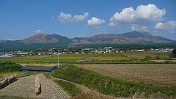 View of Mount Aso from Minami-Aso | |
 Flag  Chapter | |
 Location of Minamiaso in Kumamoto Prefecture | |
 Minamiaso Location in Japan | |
| Coordinates: 32°49′N 131°2′E / 32.817°N 131.033°E | |
| Country | Japan |
| Region | Kyushu |
| Prefecture | Kumamoto Prefecture |
| District | Aso |
| Government | |
| • Mayor | Seiichi Kira (since 2017) |
| Area | |
| • Total | 137.30 km2 (53.01 sq mi) |
| Population (October 1, 2016) | |
| • Total | 11,086 |
| • Density | 81/km2 (210/sq mi) |
| Time zone | UTC+09:00 (JST) |
| City hall address | 145-3 Kain, Minamiaso-mura, Aso-gun, Kumamoto-ken 869-1411 |
| Climate | Cfa |
| Website | www |
| Symbols | |
| Bird | Emberiza cioides |
| Flower | Pieris japonica |
| Tree | Chamaecyparis obtusa |
It was formed on February 13, 2005 from the merger of the villages of Chōyō, Hakusui and Kugino. Neighbouring towns are Takamori, Ōzu, and Nishihara.
As of April 30, 2019, the village has an estimated population of 10,535 and a population density of 77 persons per km². The total area is 137.30 km².
Geography edit
Climate edit
Minamiaso has a humid subtropical climate (Köppen climate classification Cfa) with hot summers and cool winters. Precipitation is high, but there is a pronounced difference between the wetter summers and drier winters. The average annual temperature in Minamiaso is 14.4 °C (57.9 °F). The average annual rainfall is 2,922.8 mm (115.07 in) with July as the wettest month. The temperatures are highest on average in August, at around 25.5 °C (77.9 °F), and lowest in January, at around 3.7 °C (38.7 °F).[1] The highest temperature ever recorded in Minamiaso was 36.2 °C (97.2 °F) on 8 August 2015; the coldest temperature ever recorded was −10.0 °C (14.0 °F) on 24 January 2016 and 8 January 2021.[2]
| Climate data for Minamiaso (2015−2020 normals, extremes 2015−present) | |||||||||||||
|---|---|---|---|---|---|---|---|---|---|---|---|---|---|
| Month | Jan | Feb | Mar | Apr | May | Jun | Jul | Aug | Sep | Oct | Nov | Dec | Year |
| Record high °C (°F) | 19.2 (66.6) |
20.8 (69.4) |
23.5 (74.3) |
28.3 (82.9) |
31.2 (88.2) |
32.3 (90.1) |
34.8 (94.6) |
36.2 (97.2) |
31.8 (89.2) |
30.7 (87.3) |
25.4 (77.7) |
21.9 (71.4) |
36.2 (97.2) |
| Mean daily maximum °C (°F) | 8.7 (47.7) |
9.9 (49.8) |
14.3 (57.7) |
19.4 (66.9) |
24.2 (75.6) |
25.9 (78.6) |
29.4 (84.9) |
31.1 (88.0) |
26.7 (80.1) |
22.3 (72.1) |
17.0 (62.6) |
10.9 (51.6) |
20.0 (68.0) |
| Daily mean °C (°F) | 3.7 (38.7) |
4.5 (40.1) |
8.3 (46.9) |
13.5 (56.3) |
18.1 (64.6) |
21.2 (70.2) |
24.8 (76.6) |
25.5 (77.9) |
21.7 (71.1) |
16.3 (61.3) |
10.6 (51.1) |
5.3 (41.5) |
14.5 (58.0) |
| Mean daily minimum °C (°F) | −1.0 (30.2) |
−0.5 (31.1) |
2.4 (36.3) |
7.5 (45.5) |
12.4 (54.3) |
17.0 (62.6) |
21.2 (70.2) |
21.2 (70.2) |
17.6 (63.7) |
11.0 (51.8) |
4.9 (40.8) |
0.1 (32.2) |
9.5 (49.1) |
| Record low °C (°F) | −10.0 (14.0) |
−9.3 (15.3) |
−5.0 (23.0) |
−1.7 (28.9) |
1.8 (35.2) |
10.2 (50.4) |
14.5 (58.1) |
15.4 (59.7) |
6.8 (44.2) |
1.5 (34.7) |
−4.7 (23.5) |
−6.3 (20.7) |
−10.0 (14.0) |
| Average precipitation mm (inches) | 96.8 (3.81) |
127.7 (5.03) |
145.7 (5.74) |
196.8 (7.75) |
215.8 (8.50) |
639.3 (25.17) |
656.4 (25.84) |
204.2 (8.04) |
294.9 (11.61) |
136.0 (5.35) |
99.3 (3.91) |
109.9 (4.33) |
2,922.8 (115.07) |
| Average snowfall cm (inches) | 4 (1.6) |
5 (2.0) |
trace | 0 (0) |
0 (0) |
0 (0) |
0 (0) |
0 (0) |
0 (0) |
0 (0) |
0 (0) |
trace | 9 (3.5) |
| Average precipitation days (≥ 1.0 mm) | 7.0 | 9.5 | 11.3 | 10.8 | 10.7 | 15.8 | 14.8 | 11.0 | 13.8 | 9.3 | 9.0 | 8.0 | 131 |
| Average snowy days (≥ 3 cm) | 0.5 | 0.5 | 0 | 0 | 0 | 0 | 0 | 0 | 0 | 0 | 0 | 0 | 1 |
| Mean monthly sunshine hours | 97.9 | 118.9 | 165.0 | 175.0 | 196.3 | 124.2 | 146.3 | 204.5 | 122.8 | 158.2 | 140.2 | 116.9 | 1,766.1 |
| Source: Japan Meteorological Agency[2][1] | |||||||||||||
Demographics edit
Per Japanese census data, the population of Minamiaso in 2020 is 9,836 people.[3] Minamiaso has been conducting censuses since 1960.
| Year | Pop. | ±% |
|---|---|---|
| 1960 | 16,485 | — |
| 1965 | 14,636 | −11.2% |
| 1970 | 13,087 | −10.6% |
| 1975 | 12,797 | −2.2% |
| 1980 | 13,010 | +1.7% |
| 1985 | 13,285 | +2.1% |
| 1990 | 12,643 | −4.8% |
| 1995 | 12,864 | +1.7% |
| 2000 | 12,436 | −3.3% |
| 2005 | 12,254 | −1.5% |
| 2010 | 11,978 | −2.3% |
| 2015 | 11,503 | −4.0% |
| 2020 | 9,836 | −14.5% |
| Minamiaso population statistics[3] | ||
History edit
Minamiaso is situated within Aso Caldera, one of the largest volcanic calderas in the world. For more information, refer to the entry on Mt. Aso.
Minamiaso was once three separate villages: Chōyō, Hakusui and Kugino. In 2005, it was decided that these villages would merge along with neighboring area Tateno to become Minamiaso village, which would stretch between Ōzu and Takamori.
Merger edit
Due to declining birth rate, aging population and the opportunity to share administrative resources, discussions between the three villages (Chōyō, Hakusui and Kugino) began on April 1, 2003. The merger was complete on February 13, 2005.
Education edit
- Tokai Agricultural University
- Kumamoto Seiryou High School
There are no public high schools in Minamiaso.
Junior high schools edit
- Chōyō Junior High School
- Hakusui Junior High School
- Kugino Junior High School
Junior High School Merger edit
At the beginning of 2016, due to declining student numbers, the three junior high schools merged into a single school, named simply "Minamiaso Junior High School". Chōyō Junior High School was chosen as the new location to host the students and staff.
Elementary schools edit

- Tateno Elementary School
- Chōyō Elementary School
- West Chōyō Elementary School
- Nakamatsu Elementary School
- Hakusui Elementary School
- Ryouhei Elementary School
- Kugino Elementary School
Transportation edit
Rail edit
Trains going to Ōzu, Miyaji (Aso City) or non-express trains bound for Oita will stop at Tateno Station. Those trains bound for Ōzu will end their journey there and connecting train will be waiting at the adjacent platform. A change will also need to be made at Tateno to the Minamiaso Tetsudou line, which is not a JR line so JR Rail Passes will not be valid. From Tateno to Chōyō (the first station in Minamiaso-mura) costs 230 yen. Following the 2016 Kumamoto earthquake, the train line between Tateno and Nakamatsu Station was closed, however as of the 15th of July 2023, it has reopened.[4]
References edit
External links edit
- Official website (in Japanese)
- AsoFan.net
- Mt Torokko (Minamiaso Railway) (in Japanese)
- Minamiaso-mura Association of Tourism