


Summary
Minnertsga (Dutch pronunciation: [ˈmɪ.nərtsˌɣaː], West Frisian: Minnertsgea) is a village in Waadhoeke municipality in the province of Friesland, the Netherlands. It had a population of around 1,750 in January 2017.[3] Before 2018, the village was part of het Bildt municipality.
Minnertsga
Minnertsgea | |
|---|---|
Village | |
 The church in Minnertsga | |
 Flag  Coat of arms | |
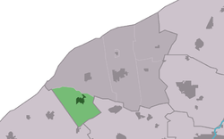 Location in het Bildt municipality | |
 Minnertsga Location in the Netherlands  Minnertsga Minnertsga (Netherlands) | |
| Coordinates: 53°15′3″N 5°35′42″E / 53.25083°N 5.59500°E | |
| Country | Netherlands |
| Province | Friesland |
| Municipality | Waadhoeke |
| Area | |
| • Total | 12.03 km2 (4.64 sq mi) |
| Elevation | 0.9 m (3.0 ft) |
| Population (2021)[1] | |
| • Total | 1,740 |
| • Density | 140/km2 (370/sq mi) |
| Postal code | 9047[1] |
| Dialing code | 0518 |
History edit
The village was first mentioned in the 13th century as Menerdkerke. It means "settlement of Meinard (person)". The name changed from kerk (church) to -ga (settlement) in the late-14th century.[4] Minnertsga is a terp (artificial living hill) village from the 8th century.[5]
The Dutch Reformed church was built in the 16th century, but has 13th century elements. The tower dates from 1505 and received a new roof in 1818. The church was damaged by fire in 1947 and restored between 1951 and 1955.[5] In 1940, the Galileërkerk in Leeuwarden was demolished,[6] and some of the headstones have been moved to Minnertsga.[7]
Minnertsga was home to 1,140 people in 1840.[7] There used to be a railway station in Minnertsga between 1902 and 1940.[8] 85% of the residents of Minnertsga are members of the local interest groep.[7]
Notable people edit
- Jacobus Mancadan (c. 1602–1680), painter and former grietman (mayor/judge)[9]
- Hendrik Wagenvoort (1886–1976), professor in Latin language and Roman religion[10]
Gallery edit
-
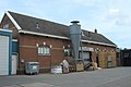 Former train station
 -
 House in Minnertsga (1968)
 -
 Street view (1968)


References edit
- ^ a b c "Kerncijfers wijken en buurten 2021". Central Bureau of Statistics. Retrieved 4 April 2022.
- ^ "Postcodetool for 9047HG". Actueel Hoogtebestand Nederland (in Dutch). Het Waterschapshuis. Retrieved 4 April 2022.
- ^ Kerncijfers wijken en buurten 2017 - CGB Statline
- ^ "Minnertsga - (geografische naam)". Etymologiebank (in Dutch). Retrieved 4 April 2022.
- ^ a b Ronald Stenvert & Sabine Broekhoven (2000). "Minnertsga" (in Dutch). Zwolle: Waanders. ISBN 90 400 9476 4. Retrieved 4 April 2022.
- ^ "Het klooster Galilea". Historisch Centrum Leeuwarden via web.archive.org (in Dutch). Archived from the original on 29 August 2018. Retrieved 4 April 2022.
- ^ a b c "Minnertsga". Plaatsengids (in Dutch). Retrieved 4 April 2022.
- ^ "station Minnertsga". Stationsweb (in Dutch). Retrieved 4 April 2022.
- ^ "Jacob Sibrandi Mancadan". Netherlands Institute for Art History. Retrieved 4 April 2022.
- ^ "Hendrik Wagenvoort". Biography portal of the Netherlands (in Dutch). Retrieved 4 April 2022.
External links edit
 Media related to Minnertsga at Wikimedia Commons
- Local interests site (in Dutch)