


Summary
30°43′N 31°15′E / 30.717°N 31.250°E
Mit Ghamr | |
|---|---|
 Old photo of children and their father playing cricket at Mit Ghamr Railway station. The father lost his leg whilst working with the Egyptian labour corps in Sinai. | |
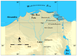 The Nile Delta | |
 Mit Ghamr Location in Egypt | |
| Coordinates: 30°43′N 31°15′E / 30.717°N 31.250°E | |
| Country | |
| Governorate | Dakahlia |
| Area | |
| • Total | 5.14 sq mi (13.31 km2) |
| Elevation | 62 ft (19 m) |
| Population (2021)[1] | |
| • Total | 153,754 |
| • Density | 30,000/sq mi (12,000/km2) |
| Time zone | UTC+2 (EST) |
Mit Ghamr (Arabic: ميت غمر, IPA: [ˈmiːt ˈɣɑmɾ]) is a town in Dakahlia Governorate, Egypt. It is a major center producing aluminium accounting for more than 70% of Egypt's total production, especially aluminum utensils. It is a city in Dakahlia Governorate, where it is second only to Al Mansurah in population and importance.
History edit
The Edinburgh Medical Missionary Society with Frederick Oakley Lasbrey founded a medical mission in Mit Ghamr in 1928.[2]
Geography edit
Mit Ghamr is located on Damietta branch of the Nile, and just on the opposite side of the Nile located another city called Zifta which belongs to Gharbia Governorate. Mit Ghamr is located in the middle of four governorates, Dakahlia to the north, Al Qaliobiah to the south, Al Sharqiah to the east and Al Gharbiah to the west. It is about 43 kilometers away from Al Mansurah and 28 kilometers away from Zagazig, the capital of Sharqia, also about 35 kilometers from Banha, the capital of Qalyubia, and 29 kilometers from Tanta, the capital of Al Gharbiah.
Villages edit
Mit Ghamr includes many villages such as Mit Yaeish, Mit El Faramawi, Mit Nagy, Dundait, Masara, Simbo Maqam, Makkam, Kafr Serenga, Sant Mai, and Sanafa. Those villages are located around the city where farmers grow various crops such as corn, rice, wheat and cotton.
Climate edit
Köppen-Geiger climate classification system classifies its climate as hot desert (BWh).
| Climate data for Mit Ghamr | |||||||||||||
|---|---|---|---|---|---|---|---|---|---|---|---|---|---|
| Month | Jan | Feb | Mar | Apr | May | Jun | Jul | Aug | Sep | Oct | Nov | Dec | Year |
| Mean daily maximum °C (°F) | 18.7 (65.7) |
20 (68) |
22.8 (73.0) |
27 (81) |
31.6 (88.9) |
33.8 (92.8) |
34 (93) |
34 (93) |
32.1 (89.8) |
29.6 (85.3) |
25 (77) |
20.7 (69.3) |
27.4 (81.4) |
| Daily mean °C (°F) | 12 (54) |
12.9 (55.2) |
15.4 (59.7) |
18.9 (66.0) |
23.1 (73.6) |
25.8 (78.4) |
26.8 (80.2) |
26.7 (80.1) |
24.8 (76.6) |
22.5 (72.5) |
19 (66) |
14.3 (57.7) |
20.2 (68.3) |
| Mean daily minimum °C (°F) | 5.4 (41.7) |
5.9 (42.6) |
8.1 (46.6) |
10.9 (51.6) |
14.7 (58.5) |
17.8 (64.0) |
19.7 (67.5) |
19.5 (67.1) |
17.5 (63.5) |
15.5 (59.9) |
13 (55) |
8 (46) |
13.0 (55.3) |
| Average precipitation mm (inches) | 9 (0.4) |
6 (0.2) |
5 (0.2) |
2 (0.1) |
2 (0.1) |
0 (0) |
0 (0) |
0 (0) |
0 (0) |
3 (0.1) |
6 (0.2) |
10 (0.4) |
43 (1.7) |
| Source: Climate-Data.org[3] | |||||||||||||
Education edit
In Tafahna, one of the many villages surrounding Mit Ghamr, is a newly-founded branch of Al Azhar University. This university was built by locals and serves hundreds of students.
Religion edit
Mit Ghamr also has a large Coptic Orthodox Church, called Marigirgis church. The church has been there for many years. Some people thought that Saint George appeared in the church around the year 1920 when there was a big fire in the town and the church was the only place saved from the fire, claiming that they saw him hovering on top of the church with his horse.
Mit Ghamr was the town in which Dr. Ahmad El Naggar set up the first Islamic bank which pioneered the global Islamic Banking system.[4]
Notable people edit
Mit Ghamr is home to one of the best known Islamic scholars, Sheikh Muhammad Metwally Al Shaarawy, who was born in the village of Dakadous where he was finally buried.
References edit
- ^ a b c "Mīt Ghamr (Kism (fully urban), Egypt) - Population Statistics, Charts, Map and Location". citypopulation.de. Retrieved 17 June 2023.
- ^ "Aug 1928, The Mission Hospital - Church Missionary Society Periodicals - Adam Matthew Digital". www.churchmissionarysociety.amdigital.co.uk. Retrieved 2023-12-11.
- ^ "Climate: Mit Ghamr - Climate graph, Temperature graph, Climate table". Climate-Data.org. Retrieved 14 August 2013.
- ^ شحاتة, حسين حسين (2009-01-01). المصارف الإسلامية (in Arabic). Al Manhal. ISBN 978-9796500123.