
KNOWPIA
WELCOME TO KNOWPIA

Mizda District 
Summary
Mizda was one of the districts of Libya. In the 2007 reorganization of Libyan districts its territory became part of Jabal al Gharbi District.[1]
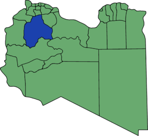
Prior to 2007 Mizdah bordered the following districts:
- Bani Walid - northeast
- Sirte - east
- Al Jufrah - southeast
- Wadi Al Shatii - south
- Ghadames - west
- Nalut - northwest, south of Yafran
- Yafran - northwest, north of Nalut
- Gharyan - north
- Tarhuna wa Msalata - northeast, at a quadripoint
At the time Mizda bordered more districts than any other Libyan district.
Settlements edit
The following are important settlements in the former Mizda District:[2]
- Mizda (مزدة) a town at 31° 25' 20"N 12° 57' 0"E
- Nasmah (-نسمة) a village at 31° 23' 0 N 13° 17' 0 E
- Bi'r Abu al Ghurab or Abu West (أبو الغرب) a village at 30° 38' 0 N 13° 36' 0 E
- Al Qaryah al Gharbīyah (القرية الغربية) at 30° 24' 24" N 13° 25' 14" E
- Tabaqa (طبقة) at 30° 25' 53" N 13° 19' 7" E [3]
- Ash Shuwayrif or Esc Sciuere (الشويرف) at 29° 59' 20" N 14° 15' 20" E[4]
- Fessano or Fisānū (فسانو) also Fessano Almchachep (منطقة فسانو) or Sawani Fassanu at 31° 18' 19" N 12° 47' 42" E
- Qaryat (القرية الشرقية) at 30° 23' 17" N 13° 34' 50" E
- Ash Shaqiqa (الشقيقة) a village at 31° 38' 22" N 12° 48' 24" E
Notes edit
- ^ شعبيات الجماهيرية العظمى – Sha'biyat of Great Jamahiriya Archived 2009-02-07 at the Wayback Machine, accessed 21 June 2009, in Arabic
- ^ Districts of Libya:Mizdah Website of the General People's Committee of Libya, in Arabic, from Internet Archive dated 30 August 2006
- ^ photo of Tabaqah Panoramio
- ^ photo of Ash Shuwayrif Panoramio
31°26′N 12°59′E / 31.433°N 12.983°E