


Summary
Moana is an outer coastal suburb in the south of Adelaide, South Australia. The suburb is approximately 36.4 km from the Adelaide city centre. It lies within the City of Onkaparinga local government area, and neighbours the suburbs Seaford, Maslin Beach, Seaford Rise and Port Noarlunga[4] It is divided into two by Pedler Creek and the associated sand dune reserve. The beach is often referred to as Moana Beach.
| Moana Adelaide, South Australia | |||||||||||||||
|---|---|---|---|---|---|---|---|---|---|---|---|---|---|---|---|
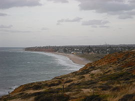 A view of Moana from the south | |||||||||||||||
 Moana | |||||||||||||||
| Coordinates | 35°11′53″S 138°28′23″E / 35.198°S 138.473°E | ||||||||||||||
| Population | 3,316 (SAL 2021)[1] | ||||||||||||||
| Postcode(s) | 5169 | ||||||||||||||
| LGA(s) | City of Onkaparinga | ||||||||||||||
| Region | Southern Adelaide[2] | ||||||||||||||
| County | Adelaide[3] | ||||||||||||||
| |||||||||||||||
| Footnotes | Adjoining suburbs[4] | ||||||||||||||
Ochre Point lies between Moana and Maslin Beach.[5] Ochre Cove, or Red Ochre Cove, lies just south of the point.[6] There is a large deposit of red ochre near the cove, which was used as a source by the traditional owners, the Kaurna people.[7] The cove was known as Potartang,[8] also spelt Putatang, or Mulgali (the latter the Ngarrindjeri word for ochre),[9] is a site of significance and part of the Tjilbruke Dreaming Trail.[8]
History edit
Moana is located on the traditional lands of the Kaurna people. Red Ochre Cove (Tindale's Ochre Cove[10]) was a source of ochre for use in ceremonies and as body paint.[8][7][11] There is a commemorative plaque marking the site of the third freshwater spring said to be created by the Kaurna ancestor creator Tjilbruke, as part of the Tjilbruke Dreaming Track created in 1986.[12]
After British colonisation of South Australia, settlers started farming the area, from about 1841. In the 1850s a local landowner lent his name to the beach and it became known as Dodd's Beach. In 1855, when shipping was the primary means of cargo transport in the area, Nashwauk was wrecked on the beach near the Pedler Creek outlet.[citation needed]
Due to an increased interest in tourism in the area, in 1927 the land was subdivided by Lake Beach Estate Ltd who held a competition to name the new town. Mr C.H. Cave won the competition with "Moana", which is a Māori-language word meaning "ocean". The land was divided into blocks of land suitable for holiday homes and wide streets were planned and laid out, but due to the Great Depression in 1929 development of the area was slow.
In the 1950s Moana experienced renewed interest from tourism as the residents of Adelaide enjoyed the freedom and mobility of car ownership – Moana was a pleasant 40-minute drive from Adelaide.
One of the landmarks of the area was the Moana Roundhouse,[13] which was demolished in 2006.[citation needed]
Beach front edit
The Gulf St Vincent beach front at Moana is a combination of low cliffs, sand dunes, and hard compacted sand. The beach at Moana is accessible by normal passenger vehicles and is one of the few beaches where cars are allowed to drive onto the beach.
Geography edit

Moana is a seaside suburb. It is divided into two by Pedler Creek and the associated sand dune reserve. The northern part of the Moana is referred to as the "old survey Moana" and the southern housing development as the "new survey".
There is a large deposit of red ochre near Red Ochre Cove,[7] sometimes referred to as Serpent's Tongue.[11]
The Coast to Vines rail trail passes through Moana. There was a station at Moana on the former Marino-Willunga rail line that it follows.
Transport edit
Moana is serviced by the 741, 745, 747, 749 and 750 bus routes which terminate at the Colonnades Shopping Centre and Noarlunga Centre railway station.
Attractions edit

Moana has a sandy beach with beginner surfing waves, so is popular with families. Moana Surf Life Saving Club patrols the beach in summer and has a beachfront cafe called Duke's, named after the Hawaiian surfer who visited Australia and helped popularize the sport. Deep Blue Cafe, expanded from the original small kiosk, is opposite the surf club. There is a playground between them next to grassed and barbecue areas. Further shops in the suburb include a fish and chip shop and health food shop. A monthly market is held at the Pioneer's Memorial Hall, which has an anchor from the Nashwauk shipwreck in front.
Moana is one of the last beaches in Adelaide where a vehicle can be driven onto the beach and parked legally, so becomes a popular tourist destination in good weather. Takeaway food options make it a destination on summer nights.
In 2008 the foreshore area of "old survey" Moana has undergone redevelopment by the local council, with improvements to the road, walkway, and sea wall. A new toilet block and shaded "gazebo", the latter shaped in the form of a seagull, have been added to the foreshore area. On warm nights this foreshore area can become a site where buskers perform for passers by, or people draw chalk mandalas.
A sloping ramp at the north end of the foreshore that originally provided access to the beach was damaged by erosion of the cliffs during storm activity in 2007. Several ramps and a staircase provided beach access along the cliff and Esplanade. Access infrastructure to the beach continues to be impacted by storm surges increasing in frequency due to climate change, requiring council maintenance and repair.
The Willunga Basin Trail now extends to Moana Beach along Pedler Creek, catering to walkers and hikers. Threatened species such as the hooded plover nest in the dunes, attracting bird watchers, though chicks' survival is threatened by dog walking and vehicles driving near the dunes.
See also edit
References edit
- ^ Australian Bureau of Statistics (28 June 2022). "Moana (suburb and locality)". Australian Census 2021 QuickStats. Retrieved 28 June 2022.
- ^ "Southern Adelaide SA Government region" (PDF). The Government of South Australia. Retrieved 17 April 2017.
- ^ "Search result for "County of Adelaide, CNTY" with the following data sets selected – "Counties" and "Local Government Areas"". Property Location SA Map Viewer. Government of South Australia. Retrieved 24 April 2017.
- ^ a b "City of Onkaparinga suburb boundaries map". City of Onkaparinga. 9 January 2014. Archived from the original on 24 September 2015. Retrieved 8 October 2014.
- ^ "Ochre Point – Beach in Maslin Beach Onkaparinga SA". SLS Beachsafe. Retrieved 16 November 2020.
- ^ "Ochre Point". Google Maps. Retrieved 16 November 2020.
- ^ a b c Popelka-Filcoff, R. S.; Lenehan, C. E.; Lombi, E.; Donner, E.; Howard, D. L.; Jonge, M. D. de; Paterson, D.; Walshe, K.; Pring, A. (22 February 1999). "Microelemental characterisation of Aboriginal Australian natural Fe oxide pigments". Analytical Methods. 7 (17): 7363–7380. doi:10.1039/C5AY01547B. hdl:2440/96867.
- ^ a b c "Tjilbruke Dreaming Tracks". Kaurnaculture. 16 October 2013. Retrieved 16 November 2020.
- ^ "Place Name Summary (PNS) 4.03.02/05: Mulgali" (PDF). Kaurna YarraPintyandi: The Southern Kaurna Place Names Project. University of Adelaide.
- ^ Tindale, Norman B. (1974). Aboriginal tribes of Australia: their terrain, environmental controls, distribution, limits, and proper names. Australian National University. p. 73. Retrieved 16 November 2020.
{{cite book}}:|website=ignored (help) - ^ a b "Grounded in Truth Walking Together". The Friends of the Heysen Trail. 29 May 2019. Retrieved 16 November 2020.
- ^ Malone, Gavin Damien Francis (2012). "Chapter 10: Kaurna Ancestor Being Tjilbruke: Commemorations". Phases of Aboriginal Inclusion in the Public Space in Adelaide, South Australia, since Colonisation (PhD). Chapter 10 PDF. Flinders University. p. 217. Retrieved 17 November 2020.
{{cite thesis}}: External link in|others= - ^ Moana Roundhouse
External links edit
- City of Onkaparinga: Moana