
KNOWPIA
WELCOME TO KNOWPIA

Monchaux-Soreng 
Summary
Monchaux-Soreng (French pronunciation: [mɔ̃ʃo sɔʁɑ̃]) is a commune in the Seine-Maritime department in the Normandy region in northern France.
Monchaux-Soreng | |
|---|---|
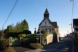 The church in Soreng | |
 Coat of arms | |
Location of Monchaux-Soreng .mw-parser-output .locmap .od{position:absolute}.mw-parser-output .locmap .id{position:absolute;line-height:0}.mw-parser-output .locmap .l0{font-size:0;position:absolute}.mw-parser-output .locmap .pv{line-height:110%;position:absolute;text-align:center}.mw-parser-output .locmap .pl{line-height:110%;position:absolute;top:-0.75em;text-align:right}.mw-parser-output .locmap .pr{line-height:110%;position:absolute;top:-0.75em;text-align:left}.mw-parser-output .locmap .pv>div{display:inline;padding:1px}.mw-parser-output .locmap .pl>div{display:inline;padding:1px;float:right}.mw-parser-output .locmap .pr>div{display:inline;padding:1px;float:left}html.skin-theme-clientpref-night .mw-parser-output .od,html.skin-theme-clientpref-night .mw-parser-output .od .pv>div,html.skin-theme-clientpref-night .mw-parser-output .od .pl>div,html.skin-theme-clientpref-night .mw-parser-output .od .pr>div{background:#000;color:#fff}html.skin-theme-clientpref-night .mw-parser-output .locmap{filter:grayscale(0.6)}@media(prefers-color-scheme:dark){html.skin-theme-clientpref-os .mw-parser-output .locmap{filter:grayscale(0.6)}html.skin-theme-clientpref-os .mw-parser-output .od,html.skin-theme-clientpref-os .mw-parser-output .od .pv>div,html.skin-theme-clientpref-os .mw-parser-output .od .pl>div,html.skin-theme-clientpref-os .mw-parser-output .od .pr>div{background:#000;color:#fff}}  Monchaux-Soreng  Monchaux-Soreng | |
| Coordinates: 49°56′57″N 1°35′38″E / 49.9492°N 1.5939°E | |
| Country | France |
| Region | Normandy |
| Department | Seine-Maritime |
| Arrondissement | Dieppe |
| Canton | Eu |
| Intercommunality | CC Aumale - Blangy-sur-Bresle |
| Government | |
| • Mayor (2020–2026) | Jean-Claude Quénot[1] |
| Area 1 | 10.05 km2 (3.88 sq mi) |
| Population (2021)[2] | 616 |
| • Density | 61/km2 (160/sq mi) |
| Time zone | UTC+01:00 (CET) |
| • Summer (DST) | UTC+02:00 (CEST) |
| INSEE/Postal code | 76441 /76340 |
| Elevation | 27–201 m (89–659 ft) (avg. 75 m or 246 ft) |
| 1 French Land Register data, which excludes lakes, ponds, glaciers > 1 km2 (0.386 sq mi or 247 acres) and river estuaries. | |
Geography edit
A forestry and farming village situated alongside the banks of the river Bresle in the Pays de Bray, some 22 miles (35 km) east of Dieppe at the junction of the D49, the D149 and the D407 roads.
Population edit
| Year | Pop. | ±% p.a. |
|---|---|---|
| 1968 | 438 | — |
| 1975 | 481 | +1.35% |
| 1982 | 576 | +2.61% |
| 1990 | 644 | +1.40% |
| 1999 | 668 | +0.41% |
| 2007 | 643 | −0.48% |
| 2012 | 647 | +0.12% |
| 2017 | 654 | +0.22% |
| Source: INSEE[3] | ||
Places of interest edit
See also edit
References edit
- ^ "Répertoire national des élus: les maires". data.gouv.fr, Plateforme ouverte des données publiques françaises (in French). 2 December 2020.
- ^ "Populations légales 2021". The National Institute of Statistics and Economic Studies. 28 December 2023.
- ^ Population en historique depuis 1968, INSEE
Wikimedia Commons has media related to Monchaux-Soreng.