
KNOWPIA
WELCOME TO KNOWPIA

Mont-Cauvaire 
Summary
Mont-Cauvaire (French pronunciation: [mɔ̃ kovɛʁ]) is a commune in the Seine-Maritime department in the Normandy region in northern France.
Mont-Cauvaire | |
|---|---|
 The dovecote of the Domaine du Fossé | |
 Coat of arms | |
Location of Mont-Cauvaire .mw-parser-output .locmap .od{position:absolute}.mw-parser-output .locmap .id{position:absolute;line-height:0}.mw-parser-output .locmap .l0{font-size:0;position:absolute}.mw-parser-output .locmap .pv{line-height:110%;position:absolute;text-align:center}.mw-parser-output .locmap .pl{line-height:110%;position:absolute;top:-0.75em;text-align:right}.mw-parser-output .locmap .pr{line-height:110%;position:absolute;top:-0.75em;text-align:left}.mw-parser-output .locmap .pv>div{display:inline;padding:1px}.mw-parser-output .locmap .pl>div{display:inline;padding:1px;float:right}.mw-parser-output .locmap .pr>div{display:inline;padding:1px;float:left}html.skin-theme-clientpref-night .mw-parser-output .od,html.skin-theme-clientpref-night .mw-parser-output .od .pv>div,html.skin-theme-clientpref-night .mw-parser-output .od .pl>div,html.skin-theme-clientpref-night .mw-parser-output .od .pr>div{background:#000;color:#fff}html.skin-theme-clientpref-night .mw-parser-output .locmap{filter:grayscale(0.6)}@media(prefers-color-scheme:dark){html.skin-theme-clientpref-os .mw-parser-output .locmap{filter:grayscale(0.6)}html.skin-theme-clientpref-os .mw-parser-output .od,html.skin-theme-clientpref-os .mw-parser-output .od .pv>div,html.skin-theme-clientpref-os .mw-parser-output .od .pl>div,html.skin-theme-clientpref-os .mw-parser-output .od .pr>div{background:#000;color:#fff}}  Mont-Cauvaire  Mont-Cauvaire | |
| Coordinates: 49°34′18″N 1°06′38″E / 49.5717°N 1.1106°E | |
| Country | France |
| Region | Normandy |
| Department | Seine-Maritime |
| Arrondissement | Rouen |
| Canton | Bois-Guillaume |
| Government | |
| • Mayor (2020–2026) | Stéphanie Lambard[1] |
| Area 1 | 9.02 km2 (3.48 sq mi) |
| Population (2021)[2] | 862 |
| • Density | 96/km2 (250/sq mi) |
| Time zone | UTC+01:00 (CET) |
| • Summer (DST) | UTC+02:00 (CEST) |
| INSEE/Postal code | 76443 /76690 |
| Elevation | 65–176 m (213–577 ft) (avg. 175 m or 574 ft) |
| 1 French Land Register data, which excludes lakes, ponds, glaciers > 1 km2 (0.386 sq mi or 247 acres) and river estuaries. | |
Geography edit
A farming village, situated along the banks of the river Cailly in the Pays de Caux, some 10 miles (16 km) north of Rouen on the D3 road.
Heraldry edit
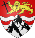 |
The arms of Mont-Cauvaire are blazoned : Gules, 2 fesses wavy abased, with a triple-peaked mount argent over them, in chief a leopard Or armed sable, langued gules, holding a latin cross bendwise sable.
|
Population edit
| Year | Pop. | ±% p.a. |
|---|---|---|
| 1968 | 451 | — |
| 1975 | 471 | +0.62% |
| 1982 | 557 | +2.42% |
| 1990 | 603 | +1.00% |
| 1999 | 566 | −0.70% |
| 2007 | 611 | +0.96% |
| 2012 | 627 | +0.52% |
| 2017 | 741 | +3.40% |
| Source: INSEE[3] | ||
Places of interest edit
- The church of St.Martin, dating from the nineteenth century.
- A sixteenth century sandstone cross.
- The seventeenth century Château du Rombosc, with its chapel, and parkland.
- The Château du Fossé, dating from the seventeenth century.
- The eighteenth century Pavillon de La Tourelle and its parkland.
- Two dovecotes and a communal oven.
See also edit
References edit
- ^ Liste des maires du département de la Seine-Maritime, 10 August 2020
- ^ "Populations légales 2021". The National Institute of Statistics and Economic Studies. 28 December 2023.
- ^ Population en historique depuis 1968, INSEE
Wikimedia Commons has media related to Mont-Cauvaire.