


Summary
Mont Albert is an inner eastern suburb of Melbourne, Victoria, Australia, 12 kilometres east of Melbourne's Central Business District,[2] located within the Cities of Boroondara and Whitehorse local government areas. Mont Albert recorded a population of 4,948 at the 2021 census.[3]
| Mont Albert Melbourne, Victoria | |||||||||||||||
|---|---|---|---|---|---|---|---|---|---|---|---|---|---|---|---|
 Hamilton Street | |||||||||||||||
 Mont Albert | |||||||||||||||
 | |||||||||||||||
| Coordinates | 37°48′58″S 145°6′36″E / 37.81611°S 145.11000°E | ||||||||||||||
| Population | 4,948 (SAL 2021)[1] | ||||||||||||||
| Postcode(s) | 3127 | ||||||||||||||
| Area | 1.6 km2 (0.6 sq mi) | ||||||||||||||
| Location | 12 km (7 mi) from Melbourne | ||||||||||||||
| LGA(s) | |||||||||||||||
| State electorate(s) | |||||||||||||||
| Federal division(s) | Kooyong | ||||||||||||||
| |||||||||||||||
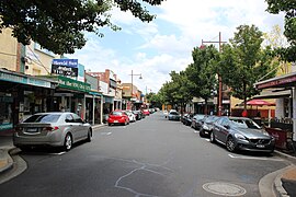
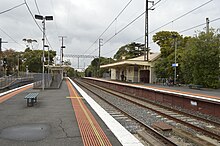
The main shopping centre of Mont Albert is Hamilton Street, a small street lined with shops. The suburb had its own railway station before being demolished as part of the Level Crossing Removal Project.
History edit
A residential subdivision south of the railway line, containing the current shopping centre, was put up for sale in 1887. The subdivision was planned in expectation of further land investment, which was delayed by the 1890s slump. Despite this, a local advancement association obtained the establishment of a railway station in 1891. The Surrey Hills golf club (1892-1907) utilized the ground on the north side of the railway line until residences appeared in any number.[4]
The local shopping centre, located just south of the railway station, began construction in 1913. In 1915, a tram service along Whitehorse Road to the suburb's north-eastern corner was established. Houses between tram and railway lines are distinguished by Edwardian, English Domestic Revival, and Arts and Crafts styles.[4]
Mont Albert was an upper middle-class neighbourhood, and its strong brick three-story elementary school (1917) boasts many outstanding students, including MPs, scholars, and a university vice-chancellor. Houses are generously proportioned and sit on large lots. In 2014, Mont Albert Primary School had 691 students.[4]
The Mont Albert businesses have kept a wider variety of retail establishments than is typical for a small town, however several were lost when the Salvation Army's southern headquarters were established there. The eastern edge of Mont Albert is Elgar Road, which has been home to a gas factory, a technical college, and the Elgar campus of Box Hill TAFE. The Kingsley Gardens public reserve is right next door.[4]

| CENSUS DATE | POPULATION |
|---|---|
| 2001 | 4143 |
| 2006 | 4419 |
| 2011 | 4954 |
Demographics edit
At the 2016 Australian Census, there were 4,840 people living in Mont Albert as their hometown.[5]
- 47.6% of the population were male and 52.4% were female.
- The median age of a resident in Mont Albert was 40 years old.
- There were 1,286 families residing in Mont Albert.
- There were 2,018 private dwellings in Mont Albert, with 1.7 motor vehicles being owned as a median.
- 52.9% of the population were married and 32.5% were never married.
- 23.5% of the registered citizens were of English ancestry, 21.4% of Australian ancestry, 13.3% of Chinese ancestry, 9.0% of Irish ancestry and 7.8% of Scottish ancestry.
- 66.6% of Citizens were born in Australia.
- 39.8% of the population in Mont Albert are irreligious, 19.3% Catholic, 11.0% Anglican, 7.2% not stated and 3.9% Uniting Church.
| Nationality | Population (2016 Census) |
|---|---|
| 452 | |
| 152 | |
| 111 | |
| 93 | |
| 91 |
Education edit
- Mont Albert Primary School, opened in 1917[7]
- Box Hill Institute (though the buildings on the East side of Elgar Road are part of Box Hill)

Public transport edit
- Cable tram
- Route 109 (Melbourne Trams) travels on Whitehorse Road through the suburb. It travels from Box Hill to Port Melbourne, and back.
- Buses
- The nearest bus terminal lies at Box Hill Railway Station, where many buses terminate and depart from. Box Hill is a neighbouring suburb of Mont Albert.
- Trains
- The Mont Albert Railway Station, which was positioned on Churchill Street, ran through the suburb. Opened in August 1890,[8] this three platform station ran along the Belgrave/Lilydale Line. Services offered were in towards the city (Flinders Street Station), or out to Blackburn, Belgrave or Lilydale, run by Metro Trains. The station was closed on 17 February 2023, as part of the Level Crossing Removal Project with the new Union station northern entrance in Mont Albert.[9]
Major attractions edit
Walking and exercise trails edit
Mont Albert (and Mont Albert North) contain many walking trails. These include:
- The Heritage Trail
- This is a Heritage Trail, about 5 km, developed by the City of Whitehorse. This starts and ends at the Mont Albert single storey railway station, constructed in 1911, and head east along Churchill Street.[10]
- Gawler Chain (Mont Albert North)
- A shared two-kilometre trail which runs along Bushy Creek. It starts near Koonung Secondary College (a local State School in Mont Albert North) and passes through several small parks and picnic grounds.[10]
- Koonung Trail (Mont Albert North)
- This trail runs through Elgar Park and through the Koonung Creek Linear Park. It passes by wetlands, which are a key feature of this trail.[10]
Eateries and stores edit
- Mont Albert boasts many cafés, restaurants and eateries of high reputation. Hamilton Street,[11] Whitehorse Road and Mont Albert Road contain many eateries which are recommended by many locals. Hamilton Street also offers many retail stores, pharmacies, butchers and supermarkets. These stores are all accessible from the street. The opening times may vary from store to store.
Sport edit
There are many sporting opportunities for people of all ages, and many clubs and facilities in the neighbouring suburbs. These include:
- Mont Albert Cricket Club
- Surrey Park Lacrosse Club
- ECHO Hockey Club
Notable people edit
- Matt Rowell, AFL footballer
- Frank Sedgman, former world No. 1 tennis player
- Jake Fraser-McGurk
Politics edit
State:
- In the 2018 Victorian State Election, the polling booth in Mont Albert returned the following votes:[12]
- Clark, Robert, Liberal Party of Victoria: 697 votes
- Hamer, Paul, Labor Party of Victoria: 585 votes
- Other candidates: 250 votes
- Despite citizens of Mont Albert favouring Robert Clark over Paul Hamer, Hamer was elected as the MP for Box Hill.
- After the distribution of preferences, Paul Hamer received 19,982 votes (52.10% of the vote), whilst Robert Clark received 18,369 votes (47.90% of the vote).
Federal:
- In the 2019 Australian Federal Election, the polling booth in Mont Albert returned the following votes:[13]
- Frydenberg, Josh, Liberal Party of Australia: 460 votes
- Burnside, Julian, Australian Greens: 284 votes
- Stewart, Jana, Australian Labor Party: 220 votes
- Other candidates: 126 votes
- The citizens of Mont Albert favoured Josh Frydenberg to be returned for a third term. Frydenberg suffered a −6.4% swing in Kooyong, however, he still retained the seat described as a 'blue ribbon' seat.
- After the distribution of preferences, Josh Frydenberg received 55,159 votes (55.70% of the vote), whilst Julian Burnside received 43,870 votes (44.30% of the vote).
See also edit
- City of Box Hill – Mont Albert was previously within this former local government area.
- List of Government Schools in Victoria – A list of Government schools, including Mont Albert Primary School
- Belgrave Railway Line
- Lilydale Railway Line
References edit
- ^ Australian Bureau of Statistics (28 June 2022). "Mont Albert (suburb and locality)". Australian Census 2021 QuickStats. Retrieved 28 June 2022.
- ^ "Postcode for Mont Albert, Victoria (Near Melbourne) - Postcodes Australia".
- ^ "2021 Census QuickStats Mont Albert". Australian Bureau of Statistics. Retrieved 3 July 2022.
- ^ a b c d "Mont Albert | Victorian Places". www.victorianplaces.com.au. Retrieved 9 May 2023.
- ^ "2016 Census QuickStats: Mont Albert". quickstats.censusdata.abs.gov.au. Retrieved 3 August 2020.
- ^ "2016 Census QuickStats: Mont Albert". quickstats.censusdata.abs.gov.au. Retrieved 4 August 2020.
- ^ School History – MONT ALBERT PRIMARY SCHOOL, retrieved 20 May 2019
- ^ "Stationeers | Mont Albert Village". Retrieved 3 August 2020.
- ^ "Mont Albert". www.metrotrains.com.au. Retrieved 3 August 2020.
- ^ a b c "Walking Trails". bpadula.tripod.com. Retrieved 3 August 2020.
- ^ "Hamilton St". Hamilton St. Retrieved 3 August 2020.
- ^ "State Election 2018: Box Hill District – First Preference Results by Voting Centre – Victorian Electoral Commission". www.vec.vic.gov.au. Retrieved 4 August 2020.
- ^ scheme=AGLSTERMS. AglsAgent; corporateName=Australian Electoral Commission; address=50 Marcus Clarke Street, Canberra. "Polling place results". Australian Electoral Commission. Retrieved 4 August 2020.
{{cite web}}: CS1 maint: multiple names: authors list (link) CS1 maint: numeric names: authors list (link)