


Summary
Mont Vernon is a town in Hillsborough County, New Hampshire, United States. The population was 2,584 at the 2020 census,[2] up from 2,409 at the 2010 census.[3]
Mont Vernon, New Hampshire | |
|---|---|
Town | |
 Town hall | |
 Location in Hillsborough County, New Hampshire | |
| Coordinates: 42°53′40″N 71°40′27″W / 42.89444°N 71.67417°W | |
| Country | United States |
| State | New Hampshire |
| County | Hillsborough |
| Incorporated | 1803 |
| Government | |
| • Board of Selectmen |
|
| • Town Administrator | Joan Cleary |
| Area | |
| • Total | 16.9 sq mi (43.8 km2) |
| • Land | 16.8 sq mi (43.6 km2) |
| • Water | 0.08 sq mi (0.2 km2) 0.49% |
| Elevation | 820 ft (250 m) |
| Population (2020)[2] | |
| • Total | 2,584 |
| • Density | 154/sq mi (59.3/km2) |
| Time zone | UTC-5 (Eastern) |
| • Summer (DST) | UTC-4 (Eastern) |
| ZIP code | 03057 |
| Area code | 603 |
| FIPS code | 33-49140 |
| GNIS feature ID | 0873670 |
| Website | www |
It is not clear why the name of the community is spelled differently from the many other towns in the United States named after Mount Vernon, the home of George Washington. Some say the "u" in "Mount" was accidentally dropped by a town clerk filling out official papers; some say the change was made deliberately to draw attention to the town; some say it uses the French spelling of "mont" as a nod to what was then the region's large French-Canadian population. According to town history, there was some dispute about how to spell the name as late as the 1920s, with the post office and one of its most prominent hotels using a "u" for many decades.[4]
History edit
Mont Vernon broke away from neighboring Amherst in 1803, following a dispute over the town parish. It later added a small portion of neighboring Lyndeborough.[5]
Mont Vernon's general history follows that of many towns in this region. Originally settled for agriculture, its farms were hard hit after the Civil War when railroads opened up better farming land in the Midwest. The town's population peaked in 1870 and began to decline.
By the late 1890s, it had become a tourist town, drawing summer visitors from points south, notably Boston, who escaped the heat in Mont Vernon's hills. At one point, it had five large summer hotels, including the Grand Hotel, located on top of Grand Hill.
The hotel business began to wither with the development of the automobile, which allowed tourists to reach places like the White Mountains of New Hampshire, and it was killed by the Great Depression. The town's population bottomed out at barely 300 in 1930, at which time the Grand Hotel was destroyed in a fire. The remaining hotels were torn down before World War II.
Since the war, Mont Vernon has slowly become a suburban community. This was significantly accelerated in 1962–1963 when engineers and technicians employed at Sanders Associates in Nashua found homes in Mont Vernon attractive. It wasn't until the 1970 census that the town's official population passed mid-19th century highs.
Agriculture, including a 1940s and 1950s boom in chicken and egg farming, has all but disappeared. As of 2019, the town has one dairy farm. The town has one general store that except for a two-year period from 2010–2012 has operated for more than 120 years in the same location.[6]
Mont Vernon made national news in March 2012 due to debate during the annual town meeting over whether to rename a small fishing hole called Jew Pond.[7] The town eventually renamed it Carleton Pond, after the family which donated the surrounding property to the town.[8]
-
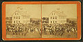 Mont Vernon scene c. 1875
 -
 North from Town Hall c. 1915
 -
 Congregational Church c. 1910
 -
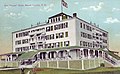 The Grand Hotel in 1909


Geography edit
According to the United States Census Bureau, the town has a total area of 16.9 square miles (43.8 km2), of which 16.8 square miles (43.6 km2) are land and 0.1 square miles (0.2 km2) are water, comprising 0.49% of the town.[1] Mont Vernon is drained by Beaver Brook, Hartshorn Brook, and Purgatory Brook, south-flowing tributaries of the Souhegan River. The northwestern corner of town is drained by Lords Brook, a northward-flowing tributary of the South Branch Piscataquog River. The entire town is part of the Merrimack River watershed. The town's highest point is on its northern border, at 1,015 feet (309 m) above sea level, near the summit of Storey Hill.
Mont Vernon is served by one state highway, New Hampshire Route 13, which passes through the center of town and leads south to Milford and north to New Boston.
Adjacent municipalities edit
- New Boston (north)
- Amherst (east)
- Milford (south)
- Lyndeborough (west)
Demographics edit
| Census | Pop. | Note | %± |
|---|---|---|---|
| 1800 | 680 | — | |
| 1810 | 762 | 12.1% | |
| 1820 | 729 | −4.3% | |
| 1830 | 763 | 4.7% | |
| 1840 | 720 | −5.6% | |
| 1850 | 722 | 0.3% | |
| 1860 | 725 | 0.4% | |
| 1870 | 601 | −17.1% | |
| 1880 | 517 | −14.0% | |
| 1890 | 479 | −7.4% | |
| 1900 | 453 | −5.4% | |
| 1910 | 413 | −8.8% | |
| 1920 | 308 | −25.4% | |
| 1930 | 302 | −1.9% | |
| 1940 | 340 | 12.6% | |
| 1950 | 405 | 19.1% | |
| 1960 | 585 | 44.4% | |
| 1970 | 906 | 54.9% | |
| 1980 | 1,444 | 59.4% | |
| 1990 | 1,812 | 25.5% | |
| 2000 | 2,034 | 12.3% | |
| 2010 | 2,409 | 18.4% | |
| 2020 | 2,584 | 7.3% | |
| U.S. Decennial Census[2][9] | |||
As of the census[10] of 2000, there were 2,034 people, 693 households, and 575 families residing in the town. The population density was 122.4 inhabitants per square mile (47.3/km2). There were 720 housing units at an average density of 43.3 per square mile (16.7/km2). The racial makeup of the town was 98.57% White, 0.15% African American, 0.15% Native American, 0.25% Asian, 0.10% from other races, and 0.79% from two or more races. Hispanic or Latino of any race were 0.54% of the population.
There were 693 households, out of which 43.3% had children under the age of 18 living with them, 73.7% were married couples living together, 5.6% had a female householder with no husband present, and 16.9% were non-families. 12.1% of all households were made up of individuals, and 6.1% had someone living alone who was 65 years of age or older. The average household size was 2.90 and the average family size was 3.17.
In the town, the population was spread out, with 29.7% under the age of 18, 4.4% from 18 to 24, 30.8% from 25 to 44, 26.0% from 45 to 64, and 9.1% who were 65 years of age or older. The median age was 38 years. For every 100 females, there were 104.8 males. For every 100 females age 18 and over, there were 103.1 males.
The median income for a household in the town was $71,250, and the median income for a family was $77,869. Males had a median income of $50,353 versus $32,500 for females. The per capita income for the town was $30,772. About 1.0% of families and 2.0% of the population were below the poverty line, including 2.3% of those under age 18 and 5.7% of those age 65 or over.
Education edit
The only public school in town is the Mont Vernon Village School. It is an elementary school, with grades kindergarten to six. For seventh and eighth grades, Mont Vernon sends its students to Amherst Middle School. For ninth through 12th grades, the students are sent to Souhegan High School, which is in Amherst but jointly owned by Amherst and Mont Vernon. Mont Vernon and Amherst comprise the school administrative unit SAU 39.[11]
Mont Vernon had a private school that started as the Appleton Academy in 1853 and was renamed the McCollom Institute in 1871, which closed shortly before the turn of the century. The building was used as a public high school for a few years, and later became the private Stearns School, which operated from 1906 to 1937, when it closed its doors due to low enrollment during the Great Depression. The building was later used for a public elementary school and now houses the police department and town offices.[12]
Fire department edit
The former two-story Mont Vernon Fire Station, built in 1947, was located on North Main Street next to the Town Hall. This station had 6 apparatus bays. In March 2007 the town voted to raze the deteriorating building and replace it with a new fire station on the same lot. The new station has 5 apparatus bays facing North Main Street, and 1 bay facing Pinkham Avenue. The Fire Chief has his office in the station, along with a radio and report room, a meeting room, and an office for the Emergency Management Director. The station also contains maintenance, storage, and work rooms. Emergency medical services are provided by Amherst.[13]
Culture edit

The town has two major annual celebrations: On the last Saturday in September, it hosts "Lamson Farm Day" at a town-owned farm to celebrate its agricultural past. In late April or early May, it has a celebration of spring called the "Mont Vernon Spring Gala". Both feature games, food and local entertainers.
Sports edit
The town has two sports teams that compete regionally. They are the Mont Vernon Falcons basketball team and the Mont Vernon Acers volleyball team. Both teams are for girls age 9–12. The Mont Vernon Village School (grades K–6) has a basketball court and volleyball court. Adult volleyball has been playing on Monday nights at the school since the early 1990s. The town owns land near the school that has a baseball field with bases, fencing and two dugouts. The adjacent field is also used for many other sports. Golf was played behind what is now the site of the post office is in the early 1900s.
There is a gun sporting range in town (the Purgatory Falls Fish & Game Club), and local hunting can be widely found in the fall. There was a ski hill with a rope tow that disbanded in the middle of the 20th century. Mont Vernon is known for views over the Souhegan Valley and has hiking trails, especially in town-owned Lamson Farm and along Purgatory Brook, which forms most of its western border. The Morrissette Trail, opened in May 2012, goes from the lowest to the highest points in Mont Vernon for an elevation gain of 700 feet (210 m) (315 to 1,015 feet (96 to 309 m)). It is sponsored by Summit for a Cure.[14]
Notable people edit
- Doc Adams (1814–1899), baseball pioneer, New York Knickerbockers player and executive
- George Wilkins Kendall (1809–1867), journalist, Mexican–American War correspondent, and founder of The New Orleans Picayune
- Erland Van Lidth De Jeude (1983–1987), actor and amateur wrestler[15]
- Ryan M. Pitts (born 1985), Congressional Medal of Honor recipient
- Alex Preston (born 1993), musician, American Idol (season 13) top 3 finalist
References edit
- ^ a b "2021 U.S. Gazetteer Files – New Hampshire". United States Census Bureau. Retrieved December 9, 2021.
- ^ a b c "Mont Vernon town, Hillsborough County, New Hampshire: 2020 DEC Redistricting Data (PL 94-171)". U.S. Census Bureau. Retrieved December 9, 2021.
- ^ United States Census Bureau, U.S. Census website, 2010 Census figures. Retrieved March 23, 2011.
- ^ Mont Vernon Historical Society: "Mont Vernon's Missing U"
- ^ Coolidge, Austin J.; John B. Mansfield (1859). A History and Description of New England. Boston, Massachusetts: A.J. Coolidge. pp. 583.
coolidge mansfield history description new england 1859.
- ^ Only in your state: Mont Vernon General Store
- ^ "Mont Vernon Residents Vote to Rename NH Fishing Spot Called Jew Pond"[dead link], Washington Post (March 14, 2012).
- ^ Michael Cleveland and Kathy Cleveland (April 20, 2012). "Mont Vernon selectmen choose Carleton Pond as new name for Jew Pond". The Telegraph. Retrieved July 25, 2014.
- ^ "Census of Population and Housing". Census.gov. Retrieved June 4, 2016.
- ^ "U.S. Census website". United States Census Bureau. Retrieved January 31, 2008.
- ^ Website for SU 39, school administrative unit
- ^ Mont Vernon Historical Society: Timeline of school in McCollom Building.
- ^ Amherst EMS Archived 2012-05-11 at the Wayback Machine
- ^ Summit For A Cure, The Morrissette Trail
- ^ Concannon, Joe. "Extraordinary young giant hulking about MIT campus", The Boston Globe, December 9, 1973. Accessed November 9, 2023, via Newspapers.com. "'We moved to Mount Vernon, N.H. after my freshman year (in Ridgefield, Conn.). (He attended Milford Area High). Wrestling never occurred to me.'"
External links edit
- Official website
- Daland Memorial Library
- New Hampshire Economic and Labor Market Information Bureau Profile