
KNOWPIA
WELCOME TO KNOWPIA

Montcornet, Aisne 
Summary
Montcornet (French pronunciation: [mɔ̃kɔʁnɛ]) is a commune in the Aisne department in Hauts-de-France in northern France.
Montcornet | |
|---|---|
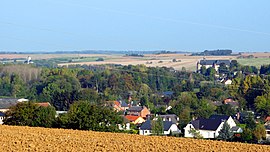 A general view of Chaourse and Montcornet | |
 Coat of arms | |
Location of Montcornet .mw-parser-output .locmap .od{position:absolute}.mw-parser-output .locmap .id{position:absolute;line-height:0}.mw-parser-output .locmap .l0{font-size:0;position:absolute}.mw-parser-output .locmap .pv{line-height:110%;position:absolute;text-align:center}.mw-parser-output .locmap .pl{line-height:110%;position:absolute;top:-0.75em;text-align:right}.mw-parser-output .locmap .pr{line-height:110%;position:absolute;top:-0.75em;text-align:left}.mw-parser-output .locmap .pv>div{display:inline;padding:1px}.mw-parser-output .locmap .pl>div{display:inline;padding:1px;float:right}.mw-parser-output .locmap .pr>div{display:inline;padding:1px;float:left}html.skin-theme-clientpref-night .mw-parser-output .od,html.skin-theme-clientpref-night .mw-parser-output .od .pv>div,html.skin-theme-clientpref-night .mw-parser-output .od .pl>div,html.skin-theme-clientpref-night .mw-parser-output .od .pr>div{background:#000;color:#fff}html.skin-theme-clientpref-night .mw-parser-output .locmap{filter:grayscale(0.6)}@media(prefers-color-scheme:dark){html.skin-theme-clientpref-os .mw-parser-output .locmap{filter:grayscale(0.6)}html.skin-theme-clientpref-os .mw-parser-output .od,html.skin-theme-clientpref-os .mw-parser-output .od .pv>div,html.skin-theme-clientpref-os .mw-parser-output .od .pl>div,html.skin-theme-clientpref-os .mw-parser-output .od .pr>div{background:#000;color:#fff}}  Montcornet  Montcornet | |
| Coordinates: 49°41′47″N 4°01′05″E / 49.6964°N 4.0181°E | |
| Country | France |
| Region | Hauts-de-France |
| Department | Aisne |
| Arrondissement | Vervins |
| Canton | Vervins |
| Intercommunality | Portes de la Thiérache |
| Government | |
| • Mayor (2020–2026) | Thomas Hennequin[1] |
| Area 1 | 5.74 km2 (2.22 sq mi) |
| Population (2021)[2] | 1,257 |
| • Density | 220/km2 (570/sq mi) |
| Time zone | UTC+01:00 (CET) |
| • Summer (DST) | UTC+02:00 (CEST) |
| INSEE/Postal code | 02502 /02340 |
| Elevation | 108–177 m (354–581 ft) (avg. 112 m or 367 ft) |
| 1 French Land Register data, which excludes lakes, ponds, glaciers > 1 km2 (0.386 sq mi or 247 acres) and river estuaries. | |
Battle of Montcornet edit
On 14 May 1940, Charles de Gaulle was given command of the new 4e Division cuirassée and ordered to execute a counterattack toward Montcornet, with the objective of slowing the German advance. This was one of the only counterattacks of the French campaign that succeeded in repulsing the German troops.
Population edit
| Year | Pop. | ±% |
|---|---|---|
| 1962 | 1,439 | — |
| 1968 | 1,486 | +3.3% |
| 1975 | 1,623 | +9.2% |
| 1982 | 1,781 | +9.7% |
| 1990 | 1,755 | −1.5% |
| 1999 | 1,690 | −3.7% |
| 2008 | 1,634 | −3.3% |
See also edit
References edit
- ^ "Répertoire national des élus: les maires" (in French). data.gouv.fr, Plateforme ouverte des données publiques françaises. 13 September 2022.
- ^ "Populations légales 2021". The National Institute of Statistics and Economic Studies. 28 December 2023.
Wikimedia Commons has media related to Montcornet, Aisne.