
KNOWPIA
WELCOME TO KNOWPIA

Montebello Vicentino 
Summary
Montebello Vicentino is a town and comune in the province of Vicenza, Veneto, northern Italy. It is west of the SP31 provincial road.
Montebello Vicentino | |
|---|---|
| Comune di Montebello Vicentino | |
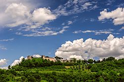 Castle of Maltraveri | |
 Coat of arms | |
Location of Montebello Vicentino .mw-parser-output .locmap .od{position:absolute}.mw-parser-output .locmap .id{position:absolute;line-height:0}.mw-parser-output .locmap .l0{font-size:0;position:absolute}.mw-parser-output .locmap .pv{line-height:110%;position:absolute;text-align:center}.mw-parser-output .locmap .pl{line-height:110%;position:absolute;top:-0.75em;text-align:right}.mw-parser-output .locmap .pr{line-height:110%;position:absolute;top:-0.75em;text-align:left}.mw-parser-output .locmap .pv>div{display:inline;padding:1px}.mw-parser-output .locmap .pl>div{display:inline;padding:1px;float:right}.mw-parser-output .locmap .pr>div{display:inline;padding:1px;float:left}html.skin-theme-clientpref-night .mw-parser-output .od,html.skin-theme-clientpref-night .mw-parser-output .od .pv>div,html.skin-theme-clientpref-night .mw-parser-output .od .pl>div,html.skin-theme-clientpref-night .mw-parser-output .od .pr>div{background:#000;color:#fff}html.skin-theme-clientpref-night .mw-parser-output .locmap{filter:grayscale(0.6)}@media(prefers-color-scheme:dark){html.skin-theme-clientpref-os .mw-parser-output .locmap{filter:grayscale(0.6)}html.skin-theme-clientpref-os .mw-parser-output .od,html.skin-theme-clientpref-os .mw-parser-output .od .pv>div,html.skin-theme-clientpref-os .mw-parser-output .od .pl>div,html.skin-theme-clientpref-os .mw-parser-output .od .pr>div{background:#000;color:#fff}}  Montebello Vicentino Location of Montebello Vicentino in Italy  Montebello Vicentino Montebello Vicentino (Veneto) | |
| Coordinates: 45°27′N 11°23′E / 45.450°N 11.383°E | |
| Country | Italy |
| Region | Veneto |
| Province | Vicenza |
| Frazioni | Bacino del Guà, Selva, Agugliana, Mason, Ca' Sordis |
| Government | |
| • Mayor | Dino Magnabosco (UDC) |
| Area | |
| • Total | 21.48 km2 (8.29 sq mi) |
| Elevation | 48 m (157 ft) |
| Population (30 November 2017)[2] | |
| • Total | 6,544 |
| • Density | 300/km2 (790/sq mi) |
| Demonym | Montebellani |
| Time zone | UTC+1 (CET) |
| • Summer (DST) | UTC+2 (CEST) |
| Postal code | 36054 |
| Dialing code | 0444 |
| Patron saint | St. John |
| Saint day | June 24 |
| Website | Official website |
Sources edit
- (Google Maps)