


Summary
Montemagno (Montmagn in Piedmontese) is a comune (municipality) in the Province of Asti in the Italian region Piedmont, located about 50 kilometres (31 mi) east of Turin and about 13 kilometres (8 mi) northeast of Asti. As of 31 December 2010 it had a population of 1,228 and an area of 15.9 square kilometres (6.1 sq mi).[2]
Montemagno | |
|---|---|
 Panorama of Montemagno | |
 Coat of arms | |
Location of Montemagno .mw-parser-output .locmap .od{position:absolute}.mw-parser-output .locmap .id{position:absolute;line-height:0}.mw-parser-output .locmap .l0{font-size:0;position:absolute}.mw-parser-output .locmap .pv{line-height:110%;position:absolute;text-align:center}.mw-parser-output .locmap .pl{line-height:110%;position:absolute;top:-0.75em;text-align:right}.mw-parser-output .locmap .pr{line-height:110%;position:absolute;top:-0.75em;text-align:left}.mw-parser-output .locmap .pv>div{display:inline;padding:1px}.mw-parser-output .locmap .pl>div{display:inline;padding:1px;float:right}.mw-parser-output .locmap .pr>div{display:inline;padding:1px;float:left}html.skin-theme-clientpref-night .mw-parser-output .od,html.skin-theme-clientpref-night .mw-parser-output .od .pv>div,html.skin-theme-clientpref-night .mw-parser-output .od .pl>div,html.skin-theme-clientpref-night .mw-parser-output .od .pr>div{background:#000;color:#fff}html.skin-theme-clientpref-night .mw-parser-output .locmap{filter:grayscale(0.6)}@media(prefers-color-scheme:dark){html.skin-theme-clientpref-os .mw-parser-output .locmap{filter:grayscale(0.6)}html.skin-theme-clientpref-os .mw-parser-output .od,html.skin-theme-clientpref-os .mw-parser-output .od .pv>div,html.skin-theme-clientpref-os .mw-parser-output .od .pl>div,html.skin-theme-clientpref-os .mw-parser-output .od .pr>div{background:#000;color:#fff}}  Montemagno Location of Montemagno in Italy  Montemagno Montemagno (Piedmont) | |
| Coordinates: 44°59′N 8°19′E / 44.983°N 8.317°E | |
| Country | Italy |
| Region | Piedmont |
| Province | Province of Asti (AT) |
| Frazioni | Santo Stefano, San Carlo |
| Government | |
| • Mayor | Paolo Porta (since 8 June 2009) (La tua voce per il paese) |
| Area | |
| • Total | 15.9 km2 (6.1 sq mi) |
| Elevation | 260 m (850 ft) |
| Population (31 December 2010)[2] | |
| • Total | 1,203 |
| • Density | 76/km2 (200/sq mi) |
| Demonym | Montemagnesi |
| Time zone | UTC+1 (CET) |
| • Summer (DST) | UTC+2 (CEST) |
| Postal code | 14030 |
| Dialing code | 0141 |
| Patron saint | St. Martin of Tours |
| Saint day | 11 November |
| Website | http://www.comune.montemagno.at.it/ |
The municipality of Montemagno contains the frazioni (subdivisions, mainly villages and hamlets) Santo Stefano and San Carlo.
Montemagno borders the following municipalities: Altavilla Monferrato (AL), Casorzo, Castagnole Monferrato, Grana, Refrancore, and Viarigi.
Founded around the year 1000, Montemagno is a hamlet consisting of twelve alleys labeled by Roman numerals connoting its identity, and is included in the "Castelli Aperti" circuit in southern Piedmont.
Attractions and landmarks edit
The Casa sul portone, the last remaining gate of the defensive wall, and the Baroque Cumiana-stone staircase are historically valuable.
The chiesa di San Vittore, the Romanesque church dedicated to Saint Victor[clarification needed], with a high bell tower at its side, is appreciable from an architectural standpoint.
The chiesa campestre di Santa Maria di Vallinò, the small country church dedicated to Vallinò's Madonna, where the local population makes frequent pilgrimages to, is immersed in the countryside. In the last years the small church has been a picnicking place for tourists, thanks to its privileged location at the center of a valley among the hills of the village.
On La Stampa daily newspaper, the square of the chiesa parrocchiale dei Santi Martino e Stefano was mentioned as one of the most beautiful squares in Piedmont, because the staircase and the church dominating it are very similar to the ones at Piazza di Spagna in Rome.[3]
- Attractions and landmarks
-
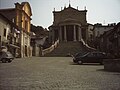 Chiesa parrocchiale dei Santi Martino e Stefano
 -
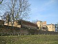 The castle
 -
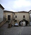 Casa sul Portone
 -
 Torre di San Vittore
 -
 Chiesa della Confraternita di San Michele Arcangelo
 -
 Chiesa della Confraternita della Santissima Trinità
 -
 Chiesa di Santa Maria della Cava


Demographic evolution edit

Notable people edit
- Bice Mortara Garavelli, linguist
- Umberto Lombardo, football player
- Luigi Giuseppe Lasagna, second Salesian bishop, missionary in Brazil
- Luigi Bianco, archbishop, Apostolic nuncio in Honduras
References edit
- ^ "Superficie di Comuni Province e Regioni italiane al 9 ottobre 2011". Italian National Institute of Statistics. Retrieved 16 March 2019.
- ^ a b (in Italian) All demographics and other statistics from the Italian statistical institute Istat.
- ^ Rossi, Andrea (28 June 2006). "Speciale piazze del Piemonte – Alla riscoperta di uno spazio che si rinnova – L'itinerario attraverso 32 piazze storiche piemontesi tra fascino, porticati medievali e spazi ruderizzati". La Stampa (in Italian). pp. 40–41. Archived from the original on 12 January 2013. Retrieved 8 April 2012.
External links edit
- (in Italian) Institutional website
- (in Italian) Montemagno by MonferratoArte, a website containing a wide historical-bibliographical repertoire of the artists working at the suburban churches in the Diocese of Casale Monferrato
- (in Italian) Portfolio fotografico [Photographic Portfolio] (archived), from the municipality of Montemagno's old website