
KNOWPIA
WELCOME TO KNOWPIA

Montfoort 
Summary
Montfoort (Dutch pronunciation: [ˈmɔntfoːrt] ⓘ) is a municipality and a city in the Netherlands, in the province of Utrecht. Montfoort received city rights in 1329.
Montfoort | |
|---|---|
 Montfoort city centre | |
 Flag  Coat of arms | |
 Location in Utrecht | |
| Coordinates: 52°3′N 4°57′E / 52.050°N 4.950°E | |
| Country | Netherlands |
| Province | Utrecht |
| Government | |
| • Body | Municipal council |
| • Mayor | Petra van Hartskamp (VVD) |
| Area | |
| • Total | 38.20 km2 (14.75 sq mi) |
| • Land | 37.57 km2 (14.51 sq mi) |
| • Water | 0.63 km2 (0.24 sq mi) |
| Elevation | 2 m (7 ft) |
| Population (January 2021)[4] | |
| • Total | 13,896 |
| • Density | 370/km2 (1,000/sq mi) |
| Time zone | UTC+1 (CET) |
| • Summer (DST) | UTC+2 (CEST) |
| Postcode | 3417, 3460–3461 |
| Area code | 0348 |
| Website | www |
Population centres edit
The municipality of Montfoort consists of the following cities, towns, villages and/or districts:
- Achthoven
- Achthoven-Oost
- Blokland
- Cattenbroek
- Heeswijk
- Knollemanshoek
- Linschoten
- Mastwijk
- Montfoort
- Willeskop
Topography edit
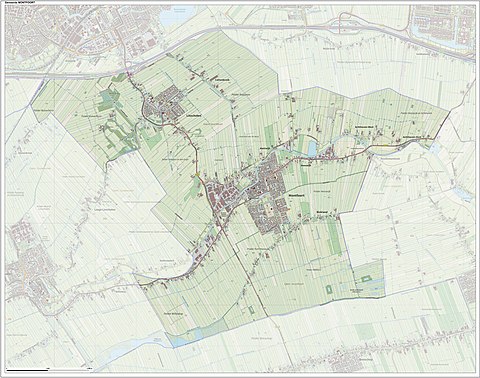
Dutch topographic map of the municipality of Montfoort, June 2015
Notable people edit
- Jan III van Montfoort (ca.1448 – 1522) a leader of the Hook Party in the Bishopric of Utrecht
- Anthonie Blocklandt van Montfoort (1533 or 1534 - 1583) a Dutch painter
- Isbrand van Diemerbroeck (1609–1674) a Dutch physician, anatomist and professor
- Matthew Maty (1718–1776) a physician and writer, secretary of the Royal Society and librarian of the British Museum[5]
- Mark van Eldik (born 1967) a Dutch rally driver
Gallery edit
-
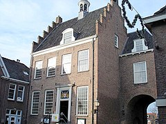 Old town hall of Montfoort
 -
 Montfoort Utrecht with the still working flourmill
 -
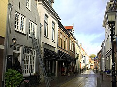 De Hoogstraat de oudste en belangrijkste straat van Montfoort
 -
 View to Montfoort
 -
 Montfoort, church: kerk Johannes de Doper
 -
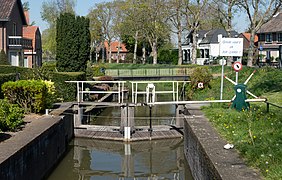 Lock: schutsluis Montfoortse Vaart
 -
![Kasteel Montfoort [nl]](//upload.wikimedia.org/wikipedia/commons/thumb/f/fa/Kasteel_Montfoort_Panorama_7.JPG/406px-Kasteel_Montfoort_Panorama_7.JPG) Kasteel Montfoort
Kasteel Montfoort


![Kasteel Montfoort [nl]](http://upload.wikimedia.org/wikipedia/commons/thumb/f/fa/Kasteel_Montfoort_Panorama_7.JPG/406px-Kasteel_Montfoort_Panorama_7.JPG)
See also edit
References edit
- ^ "burgemeester E.L. (Bert) Jansen" [mayor E.L. (Bert) Jansen] (in Dutch). Gemeente Montfoort. Archived from the original on 8 April 2014. Retrieved 7 April 2014.
- ^ "Kerncijfers wijken en buurten 2020" [Key figures for neighbourhoods 2020]. StatLine (in Dutch). CBS. 24 July 2020. Retrieved 19 September 2020.
- ^ "Postcodetool for 3417JG". Actueel Hoogtebestand Nederland (in Dutch). Het Waterschapshuis. Retrieved 7 April 2014.
- ^ "Bevolkingsontwikkeling; regio per maand" [Population growth; regions per month]. CBS Statline (in Dutch). CBS. 1 January 2021. Retrieved 2 January 2022.
- ^ Dictionary of National Biography, 1885-1900, Volume 37, Maty, Matthew retrieved 20 December 2019
External links edit
 Media related to Montfoort at Wikimedia Commons
- Official website