
KNOWPIA
WELCOME TO KNOWPIA

Montpont-en-Bresse 
Summary
Montpont-en-Bresse (French pronunciation: [mɔ̃pɔ̃ ɑ̃ bʁɛs], literally Montpont in Bresse) is a commune in the Saône-et-Loire department in the region of Bourgogne-Franche-Comté in eastern France.
Montpont-en-Bresse | |
|---|---|
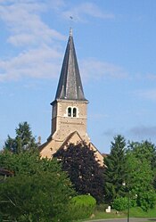 The church in Montpont-en-Bresse | |
 Coat of arms | |
Location of Montpont-en-Bresse .mw-parser-output .locmap .od{position:absolute}.mw-parser-output .locmap .id{position:absolute;line-height:0}.mw-parser-output .locmap .l0{font-size:0;position:absolute}.mw-parser-output .locmap .pv{line-height:110%;position:absolute;text-align:center}.mw-parser-output .locmap .pl{line-height:110%;position:absolute;top:-0.75em;text-align:right}.mw-parser-output .locmap .pr{line-height:110%;position:absolute;top:-0.75em;text-align:left}.mw-parser-output .locmap .pv>div{display:inline;padding:1px}.mw-parser-output .locmap .pl>div{display:inline;padding:1px;float:right}.mw-parser-output .locmap .pr>div{display:inline;padding:1px;float:left}html.skin-theme-clientpref-night .mw-parser-output .od,html.skin-theme-clientpref-night .mw-parser-output .od .pv>div,html.skin-theme-clientpref-night .mw-parser-output .od .pl>div,html.skin-theme-clientpref-night .mw-parser-output .od .pr>div{background:#000;color:#fff}html.skin-theme-clientpref-night .mw-parser-output .locmap{filter:grayscale(0.6)}@media(prefers-color-scheme:dark){html.skin-theme-clientpref-os .mw-parser-output .locmap{filter:grayscale(0.6)}html.skin-theme-clientpref-os .mw-parser-output .od,html.skin-theme-clientpref-os .mw-parser-output .od .pv>div,html.skin-theme-clientpref-os .mw-parser-output .od .pl>div,html.skin-theme-clientpref-os .mw-parser-output .od .pr>div{background:#000;color:#fff}}  Montpont-en-Bresse  Montpont-en-Bresse | |
| Coordinates: 46°33′29″N 5°09′54″E / 46.5581°N 5.165°E | |
| Country | France |
| Region | Bourgogne-Franche-Comté |
| Department | Saône-et-Loire |
| Arrondissement | Louhans |
| Canton | Cuiseaux |
| Intercommunality | CC Terres de Bresse |
| Government | |
| • Mayor (2020–2026) | Anne Moreira[1] |
| Area 1 | 37.46 km2 (14.46 sq mi) |
| Population (2021)[2] | 1,091 |
| • Density | 29/km2 (75/sq mi) |
| Time zone | UTC+01:00 (CET) |
| • Summer (DST) | UTC+02:00 (CEST) |
| INSEE/Postal code | 71318 /71470 |
| Elevation | 182–213 m (597–699 ft) (avg. 198 m or 650 ft) |
| 1 French Land Register data, which excludes lakes, ponds, glaciers > 1 km2 (0.386 sq mi or 247 acres) and river estuaries. | |
Geography edit
The Sâne Morte forms the commune's south-eastern border. The Sâne Vive flows northwestward through the middle of the commune.
See also edit
References edit
- ^ "Répertoire national des élus: les maires". data.gouv.fr, Plateforme ouverte des données publiques françaises (in French). 2 December 2020.
- ^ "Populations légales 2021". The National Institute of Statistics and Economic Studies. 28 December 2023.
Wikimedia Commons has media related to Montpont-en-Bresse.