
KNOWPIA
WELCOME TO KNOWPIA

Montreuil-Bellay 
Summary
Montreuil-Bellay (French pronunciation: [mɔ̃tʁœj bɛlɛ] ⓘ) is a commune in the Maine-et-Loire department in western France.
Montreuil-Bellay | |
|---|---|
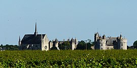 A general view of Montreuil-Bellay | |
 Coat of arms | |
Location of Montreuil-Bellay .mw-parser-output .locmap .od{position:absolute}.mw-parser-output .locmap .id{position:absolute;line-height:0}.mw-parser-output .locmap .l0{font-size:0;position:absolute}.mw-parser-output .locmap .pv{line-height:110%;position:absolute;text-align:center}.mw-parser-output .locmap .pl{line-height:110%;position:absolute;top:-0.75em;text-align:right}.mw-parser-output .locmap .pr{line-height:110%;position:absolute;top:-0.75em;text-align:left}.mw-parser-output .locmap .pv>div{display:inline;padding:1px}.mw-parser-output .locmap .pl>div{display:inline;padding:1px;float:right}.mw-parser-output .locmap .pr>div{display:inline;padding:1px;float:left}html.skin-theme-clientpref-night .mw-parser-output .od,html.skin-theme-clientpref-night .mw-parser-output .od .pv>div,html.skin-theme-clientpref-night .mw-parser-output .od .pl>div,html.skin-theme-clientpref-night .mw-parser-output .od .pr>div{background:#000;color:#fff}html.skin-theme-clientpref-night .mw-parser-output .locmap{filter:grayscale(0.6)}@media(prefers-color-scheme:dark){html.skin-theme-clientpref-os .mw-parser-output .locmap{filter:grayscale(0.6)}html.skin-theme-clientpref-os .mw-parser-output .od,html.skin-theme-clientpref-os .mw-parser-output .od .pv>div,html.skin-theme-clientpref-os .mw-parser-output .od .pl>div,html.skin-theme-clientpref-os .mw-parser-output .od .pr>div{background:#000;color:#fff}}  Montreuil-Bellay  Montreuil-Bellay | |
| Coordinates: 47°07′56″N 0°09′08″W / 47.1322°N 0.1522°W | |
| Country | France |
| Region | Pays de la Loire |
| Department | Maine-et-Loire |
| Arrondissement | Saumur |
| Canton | Doué-en-Anjou |
| Intercommunality | CA Saumur Val de Loire |
| Government | |
| • Mayor (2020–2026) | Marc Bonnin[1] |
| Area 1 | 48.96 km2 (18.90 sq mi) |
| Population (2021)[2] | 3,710 |
| • Density | 76/km2 (200/sq mi) |
| Demonym(s) | Montreuillais, Montreuillaise |
| Time zone | UTC+01:00 (CET) |
| • Summer (DST) | UTC+02:00 (CEST) |
| INSEE/Postal code | 49215 /49260 |
| Elevation | 29–73 m (95–240 ft) (avg. 54 m or 177 ft) |
| Website | Official website |
| 1 French Land Register data, which excludes lakes, ponds, glaciers > 1 km2 (0.386 sq mi or 247 acres) and river estuaries. | |
It is located approximately 15 km to the south of Saumur, and is famous for the Château de Montreuil-Bellay, which is situated in the town.
Montreuil-Bellay is on the Thouet, and was the head of navigation until navigation ceased at the beginning of the 20th century.[3] The navigation works were undertaken in the 15th century by the lords of Montreuil-Bellay, who in turn were granted letters patent by King Charles VII allowing them to raise a tax on wine that would pass through their land.[4] Montreuil-Bellay station has rail connections to Tours, Saumur, Bressuire and La Roche-sur-Yon.
Population edit
| Year | Pop. | ±% p.a. |
|---|---|---|
| 1968 | 3,086 | — |
| 1975 | 3,989 | +3.73% |
| 1982 | 4,093 | +0.37% |
| 1990 | 4,041 | −0.16% |
| 1999 | 4,112 | +0.19% |
| 2007 | 4,045 | −0.21% |
| 2012 | 4,032 | −0.06% |
| 2017 | 3,822 | −1.06% |
| Source: INSEE[5] | ||
See also edit
References edit
- ^ "Répertoire national des élus: les maires". data.gouv.fr, Plateforme ouverte des données publiques françaises (in French). 2 December 2020.
- ^ "Populations légales 2021". The National Institute of Statistics and Economic Studies. 28 December 2023.
- ^ "Vers une reconnaissance de la responsabilité de la France dans l'inter". 28 October 2016.
- ^ Bouchet, François. La Vallée du Thouet. pp. 124–128.
- ^ Population en historique depuis 1968, INSEE
Wikimedia Commons has media related to Montreuil-Bellay.