


Summary
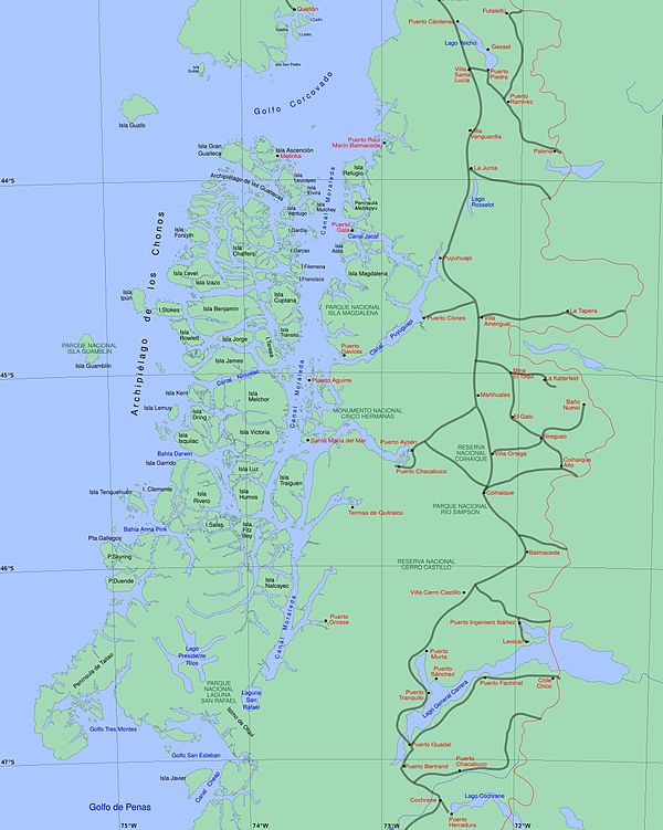
Moraleda Channel (Spanish: Canal Moraleda) is a body of water separating the Chonos Archipelago from the mainland of Chile. It is located at 44°24′53″S 73°25′14″W / 44.4147222°S 73.4205556°W, leading to Gulf of Corcovado. Southward from the mouth of the Aisén Fjord, Moraleda Channel divides into two arms. The east arm, called Canal Costa (Costa Channel), is the main one. Farther south the name changes to Estero Elefantes (Elefantes Estuary), which terminates in the gulf of the same name. The channel runs along the Liquiñe-Ofqui Fault.
| Moraleda Channel | |
|---|---|
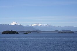 Canal Moraleda with Cerro Macá in the distance. | |
 Moraleda Channel | |
| Location | Southern America |
| Coordinates | 44°24′53″S 73°25′14″W / 44.4147222°S 73.4205556°W |
| Basin countries | Chile |
| Average depth | −50 m (−160 ft) |
The channel is named after José de Moraleda y Montero, a Spanish navy officer who explored the area in the 1780s.[1]
The deepest part of the channel are situated in west of Magdalena Island.[2]
In 1985 the discovery of merluza fishing grounds in Moraleda Channel sparkled a fishing boom (boom merluzero) that led to the spontaneous growth of two new settlements; Puerto Gaviota and Puerto Gala.[3]
References edit
- ^ Fernández, Ignacio (2009). "Jose de Moraleda y Montero: Cartógrafo de Chiloe y la Patagonia" (in Spanish). ABC de Sevilla. Retrieved August 19, 2017.[permanent dead link]
- ^ Rodrigo, Cristián (2006). "Topografía submarina en canales de la Patagonia Norte" (PDF). Avances en el Conocimiento Oceanográfico de las Aguas Interiores Chilenas, Puerto Montt a Cabo de Hornos: 19–23. Retrieved 26 April 2013.
- ^ Saavedra G., Gonzalo (2007). "Prácticas Económicas en las Costas Insulares de Aisén. Testimonios de Persistencia y Transformación" (PDF). Actas del 6º Congreso Chileno de Antropología. VI Congreso Chileno de Antropología (in Spanish). Valdivia: Colegio de Antropólogos de Chile A. G. pp. 1696–1703.
External links edit
- Chilean Navy, "General piloting regulations and information", STRAIT OF MAGELLAN, CHILEAN CHANNELS AND FIORDS Regulations and information for PILOTING. ROUTES (in Spanish), web.directemar.cl, archived from the original on 8 October 2012, retrieved 16 April 2013
- Chilean Navy, "Sailing along the Strait of Magellan or Drake Passage", STRAIT OF MAGELLAN, CHILEAN CHANNELS AND FIORDS Regulations and information for PILOTING. ROUTES (in Spanish), directemar.cl, archived from the original on 24 November 2012, retrieved 16 April 2013
- Chilean Navy, "Sailing throughout Chilean Straits, Channels and Fjords", STRAIT OF MAGELLAN, CHILEAN CHANNELS AND FIORDS Regulations and information for PILOTING. ROUTES (in Spanish), directemar.cl, archived from the original on 26 November 2012, retrieved 16 April 2013
- Ministerio de Obras Públicas de Chile (2012), "Maps of all regions of Chile", Cartas camineras 2010 in 200 dpi and 70 dpi resolution available (Maps) (in Spanish), Government of Chile, archived from the original (jpg and pdf) on 4 September 2012, retrieved 20 April 2013
- United States Hydrographic Office, South America Pilot (1916)