
KNOWPIA
WELCOME TO KNOWPIA

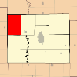
Morrow Township, Adair County, Missouri 
Summary
Morrow Township is one of ten townships in Adair County, Missouri, United States. As of the 2010 census, its population was 431.[3] It is named for John Morrow, one of Adair County's original judges.[4]
Morrow Township, Missouri | |
|---|---|
 | |
| Coordinates: 40°17′02″N 092°47′32″W / 40.28389°N 92.79222°W | |
| Country | United States |
| State | Missouri |
| County | Adair |
| Area | |
| • Total | 53.39 sq mi (138.27 km2) |
| • Land | 53.37 sq mi (138.22 km2) |
| • Water | 0.02 sq mi (0.05 km2) 0.04% |
| Elevation | 797 ft (243 m) |
| Population (2010) | |
| • Total | 431 |
| • Density | 8/sq mi (3.1/km2) |
| FIPS code | 29-50096[2] |
| GNIS feature ID | 0766213 |
Geography edit
Morrow Township covers an area of 53.39 square miles (138.27 km2) and contains no incorporated settlements. It contains eight cemeteries: Branstutter, Broyles, Campbell, Cox, Daniels, Megrew, Morelock and Shibleys Point.
The streams of Pleasant Creek, Plum Branch and Turkey Creek run through this township.
References edit
- ^ "US Board on Geographic Names". United States Geological Survey. October 25, 2007. Retrieved January 31, 2008.
- ^ "U.S. Census website". United States Census Bureau. Retrieved January 31, 2008.
- ^ "Geographic Identifiers: 2010 Demographic Profile Data (G001): Morrow township, Adair County, Missouri". U.S. Census Bureau, American Factfinder. Archived from the original on February 12, 2020. Retrieved June 20, 2013.
- ^ Violette, E. M. (1911). History of Adair County. The Denslow History Company. pp. 39.
- USGS Geographic Names Information System (GNIS)
External links edit
- US-Counties.com
- City-Data.com