


Summary
Mortsel (Dutch pronunciation: [ˈmɔrtsəl]) is a city and municipality close to the city of Antwerp located in the Belgian province of Antwerp. The municipality only comprises the city of Mortsel proper. In 2021, Mortsel had a total population of 26,170 people. The total area is 7.78 km².[2]
Mortsel | |
|---|---|
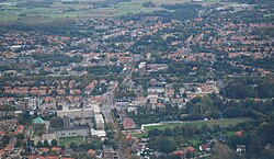 Aerial view of Mortsel | |
 Flag Coat of arms | |
Location of Mortsel .mw-parser-output .locmap .od{position:absolute}.mw-parser-output .locmap .id{position:absolute;line-height:0}.mw-parser-output .locmap .l0{font-size:0;position:absolute}.mw-parser-output .locmap .pv{line-height:110%;position:absolute;text-align:center}.mw-parser-output .locmap .pl{line-height:110%;position:absolute;top:-0.75em;text-align:right}.mw-parser-output .locmap .pr{line-height:110%;position:absolute;top:-0.75em;text-align:left}.mw-parser-output .locmap .pv>div{display:inline;padding:1px}.mw-parser-output .locmap .pl>div{display:inline;padding:1px;float:right}.mw-parser-output .locmap .pr>div{display:inline;padding:1px;float:left}html.skin-theme-clientpref-night .mw-parser-output .od,html.skin-theme-clientpref-night .mw-parser-output .od .pv>div,html.skin-theme-clientpref-night .mw-parser-output .od .pl>div,html.skin-theme-clientpref-night .mw-parser-output .od .pr>div{background:#000;color:#fff}html.skin-theme-clientpref-night .mw-parser-output .locmap{filter:grayscale(0.6)}@media(prefers-color-scheme:dark){html.skin-theme-clientpref-os .mw-parser-output .locmap{filter:grayscale(0.6)}html.skin-theme-clientpref-os .mw-parser-output .od,html.skin-theme-clientpref-os .mw-parser-output .od .pv>div,html.skin-theme-clientpref-os .mw-parser-output .od .pl>div,html.skin-theme-clientpref-os .mw-parser-output .od .pr>div{background:#000;color:#fff}}  Mortsel Location in Belgium
Location of Mortsel in the province of Antwerp  | |
| Coordinates: 51°10′N 04°28′E / 51.167°N 4.467°E | |
| Country | |
| Community | Flemish Community |
| Region | Flemish Region |
| Province | Antwerp |
| Arrondissement | Antwerp |
| Government | |
| • Mayor | Erik Broeckx (N-VA) |
| • Governing party/ies | N-VA, Vooruit-I love Mortsel, CD&V |
| Area | |
| • Total | 7.78 km2 (3.00 sq mi) |
| Population (2022-01-01)[1] | |
| • Total | 26,181 |
| • Density | 3,400/km2 (8,700/sq mi) |
| Postal codes | 2640 |
| NIS code | 11029 |
| Area codes | 03 |
| Website | www.mortsel.be |
Geography edit
The city consists of the areas Mortsel-Dorp, Oude-God and Luithagen. Mortsel is bordered by Antwerp (districts Wilrijk, Berchem and Deurne), Borsbeek, Boechout, Hove, and Edegem.
History edit
Mortsel was the scene for one of the major collateral damage tragedies of World War II. On 5 April 1943, the Minerva car factory, then used to repair Luftwaffe planes, was the target of a bombing raid by the USAAF. Most bombs missed the target and hit a residential area instead, resulting in the deaths of 936 civilians, including 209 children, exceeding the civilian death toll of the Guernica raid which modern estimates put at 400.[3]
The last V2 launched against Antwerp also fell in Mortsel, killing 27 people, on 27 March 1945.
Economy edit
The headquarters of Agfa-Gevaert are situated in Mortsel.
Notable people edit
- Alex Agnew, stand-up comedian
- Luc Brewaeys, (born in Mortsel in 1959), composer, conductor, pianist and recording producer
- Daniel Dardha, chess player
- Bart De Wever, politician
- Timo Descamps, actor
- Koen Lenaerts, President of the European Court of Justice
- Clem Schouwenaars (b. Mortsel, 1932–1993), writer
- Tamino, musician
- Luc Tuymans, painter
- Johan Van Overtveldt (born in Mortsel in 1955), Belgian journalist and politician of the New Flemish Alliance
- Jos Vandeloo, writer
See also the Category:People from Mortsel.
See also edit
References edit
- ^ Error: Unable to display the reference properly. See the documentation for details.
- ^ "Bevolking per statistische sector - Sector 11029". Statistics Belgium. Retrieved 10 May 2022.
- ^ "Bombing of Mortsel". pieterserrien.be. 3 September 2015. (in English)
External links edit
![]() Media related to Mortsel at Wikimedia Commons
Media related to Mortsel at Wikimedia Commons
- (in Dutch) Official website