
KNOWPIA
WELCOME TO KNOWPIA

Mory, Pas-de-Calais 
Summary
Mory (French pronunciation: [mɔʁi]) is a commune in the Pas-de-Calais department in the Hauts-de-France region of France.[3]
Mory | |
|---|---|
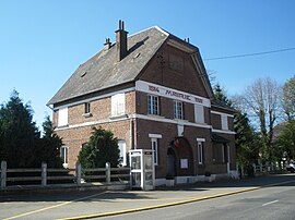 The town hall of Mory | |
 Coat of arms | |
Location of Mory .mw-parser-output .locmap .od{position:absolute}.mw-parser-output .locmap .id{position:absolute;line-height:0}.mw-parser-output .locmap .l0{font-size:0;position:absolute}.mw-parser-output .locmap .pv{line-height:110%;position:absolute;text-align:center}.mw-parser-output .locmap .pl{line-height:110%;position:absolute;top:-0.75em;text-align:right}.mw-parser-output .locmap .pr{line-height:110%;position:absolute;top:-0.75em;text-align:left}.mw-parser-output .locmap .pv>div{display:inline;padding:1px}.mw-parser-output .locmap .pl>div{display:inline;padding:1px;float:right}.mw-parser-output .locmap .pr>div{display:inline;padding:1px;float:left}html.skin-theme-clientpref-night .mw-parser-output .od,html.skin-theme-clientpref-night .mw-parser-output .od .pv>div,html.skin-theme-clientpref-night .mw-parser-output .od .pl>div,html.skin-theme-clientpref-night .mw-parser-output .od .pr>div{background:#000;color:#fff}html.skin-theme-clientpref-night .mw-parser-output .locmap{filter:grayscale(0.6)}@media(prefers-color-scheme:dark){html.skin-theme-clientpref-os .mw-parser-output .locmap{filter:grayscale(0.6)}html.skin-theme-clientpref-os .mw-parser-output .od,html.skin-theme-clientpref-os .mw-parser-output .od .pv>div,html.skin-theme-clientpref-os .mw-parser-output .od .pl>div,html.skin-theme-clientpref-os .mw-parser-output .od .pr>div{background:#000;color:#fff}}  Mory  Mory | |
| Coordinates: 50°09′25″N 2°51′12″E / 50.1569°N 2.8533°E | |
| Country | France |
| Region | Hauts-de-France |
| Department | Pas-de-Calais |
| Arrondissement | Arras |
| Canton | Bapaume |
| Intercommunality | CC Sud-Artois |
| Government | |
| • Mayor (2020–2026) | Sylvie Barbier[1] |
| Area 1 | 7.39 km2 (2.85 sq mi) |
| Population (2021)[2] | 305 |
| • Density | 41/km2 (110/sq mi) |
| Time zone | UTC+01:00 (CET) |
| • Summer (DST) | UTC+02:00 (CEST) |
| INSEE/Postal code | 62594 /62159 |
| Elevation | 87–121 m (285–397 ft) (avg. 90 m or 300 ft) |
| 1 French Land Register data, which excludes lakes, ponds, glaciers > 1 km2 (0.386 sq mi or 247 acres) and river estuaries. | |
Geography edit
Mory is situated 13 miles (21 km) south of Arras, at the junction of the D36 and D36E roads. The A1 autoroute passes by less than a mile away
Population edit
| Year | Pop. | ±% p.a. |
|---|---|---|
| 1968 | 353 | — |
| 1975 | 315 | −1.61% |
| 1982 | 314 | −0.05% |
| 1990 | 319 | +0.20% |
| 1999 | 339 | +0.68% |
| 2007 | 342 | +0.11% |
| 2012 | 332 | −0.59% |
| 2017 | 309 | −1.43% |
| Source: INSEE[4] | ||
Places of interest edit
- The church of St.Vaast, rebuilt, as was all of the village, after World War I.
- The Commonwealth War Graves Commission cemetery.
See also edit
References edit
- ^ "Répertoire national des élus: les maires" (in French). data.gouv.fr, Plateforme ouverte des données publiques françaises. 13 September 2022.
- ^ "Populations légales 2021". The National Institute of Statistics and Economic Studies. 28 December 2023.
- ^ INSEE commune file
- ^ Population en historique depuis 1968, INSEE
External links edit
Wikimedia Commons has media related to Mory (Pas-de-Calais).
- The CWGC cemetery of Mory Abbey