
KNOWPIA
WELCOME TO KNOWPIA

Motteville 
Summary
Motteville is a commune in the Seine-Maritime department in the Normandy region in northern France.
Motteville | |
|---|---|
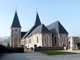 The church in Motteville | |
Location of Motteville .mw-parser-output .locmap .od{position:absolute}.mw-parser-output .locmap .id{position:absolute;line-height:0}.mw-parser-output .locmap .l0{font-size:0;position:absolute}.mw-parser-output .locmap .pv{line-height:110%;position:absolute;text-align:center}.mw-parser-output .locmap .pl{line-height:110%;position:absolute;top:-0.75em;text-align:right}.mw-parser-output .locmap .pr{line-height:110%;position:absolute;top:-0.75em;text-align:left}.mw-parser-output .locmap .pv>div{display:inline;padding:1px}.mw-parser-output .locmap .pl>div{display:inline;padding:1px;float:right}.mw-parser-output .locmap .pr>div{display:inline;padding:1px;float:left}html.skin-theme-clientpref-night .mw-parser-output .od,html.skin-theme-clientpref-night .mw-parser-output .od .pv>div,html.skin-theme-clientpref-night .mw-parser-output .od .pl>div,html.skin-theme-clientpref-night .mw-parser-output .od .pr>div{background:#000;color:#fff}html.skin-theme-clientpref-night .mw-parser-output .locmap{filter:grayscale(0.6)}@media(prefers-color-scheme:dark){html.skin-theme-clientpref-os .mw-parser-output .locmap{filter:grayscale(0.6)}html.skin-theme-clientpref-os .mw-parser-output .od,html.skin-theme-clientpref-os .mw-parser-output .od .pv>div,html.skin-theme-clientpref-os .mw-parser-output .od .pl>div,html.skin-theme-clientpref-os .mw-parser-output .od .pr>div{background:#000;color:#fff}}  Motteville  Motteville | |
| Coordinates: 49°38′10″N 0°51′22″E / 49.6361°N 0.8561°E | |
| Country | France |
| Region | Normandy |
| Department | Seine-Maritime |
| Arrondissement | Rouen |
| Canton | Yvetot |
| Intercommunality | CC Plateau de Caux-Doudeville-Yerville |
| Government | |
| • Mayor (2020–2026) | Eric Halbourg[1] |
| Area 1 | 8.68 km2 (3.35 sq mi) |
| Population (2021)[2] | 771 |
| • Density | 89/km2 (230/sq mi) |
| Time zone | UTC+01:00 (CET) |
| • Summer (DST) | UTC+02:00 (CEST) |
| INSEE/Postal code | 76456 /76970 |
| Elevation | 135–157 m (443–515 ft) (avg. 150 m or 490 ft) |
| 1 French Land Register data, which excludes lakes, ponds, glaciers > 1 km2 (0.386 sq mi or 247 acres) and river estuaries. | |
Geography edit
A farming village situated in the Pays de Caux, some 22 miles (35 km) northwest of Rouen at the junction of the D20, D89, D53 and the D336 roads. SNCF operates a TER (train) train service here.
Population edit
| Year | Pop. | ±% p.a. |
|---|---|---|
| 1968 | 604 | — |
| 1975 | 620 | +0.37% |
| 1982 | 666 | +1.03% |
| 1990 | 706 | +0.73% |
| 1999 | 730 | +0.37% |
| 2007 | 730 | +0.00% |
| 2012 | 787 | +1.52% |
| 2017 | 791 | +0.10% |
| Source: INSEE[3] | ||
Places of interest edit
- The church of St.Michel, dating from the thirteenth century.
- The Château Henri IV
- The sixteenth century fortified manorhouse.
See also edit
References edit
- ^ "Répertoire national des élus: les maires" (in French). data.gouv.fr, Plateforme ouverte des données publiques françaises. 13 September 2022.
- ^ "Populations légales 2021". The National Institute of Statistics and Economic Studies. 28 December 2023.
- ^ Population en historique depuis 1968, INSEE
External links edit
Wikimedia Commons has media related to Motteville.
- Official website of the commune (in French)