
KNOWPIA
WELCOME TO KNOWPIA

Mount Aetna, Pennsylvania 
Summary
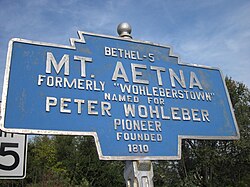
Mount Aetna is a census-designated place[3] in Tulpehocken Township, Berks County, Pennsylvania, United States. It is located along Pennsylvania Route 501 near the border of Lebanon County. The community is named after the active volcano, Mount Etna, in Sicily. As of the 2010 census, the population was 354 residents.[4]
Mount Aetna, Pennsylvania | |
|---|---|
 House in Mount Aetna | |
| Country | United States |
| State | Pennsylvania |
| County | Berks |
| Township | Tulpehocken |
| Area | |
| • Total | 0.50 sq mi (1.28 km2) |
| • Land | 0.49 sq mi (1.28 km2) |
| • Water | 0.00 sq mi (0.00 km2) |
| Population | |
| • Total | 489 |
| • Density | 987.88/sq mi (381.55/km2) |
| Time zone | UTC-5 (Eastern (EST)) |
| • Summer (DST) | UTC-4 (EDT) |
| ZIP codes | 19544 |
| FIPS code | 42-51320 |
Demographics edit
| Census | Pop. | Note | %± |
|---|---|---|---|
| 2020 | 489 | — | |
| U.S. Decennial Census[5] | |||
References edit
- ^ "ArcGIS REST Services Directory". United States Census Bureau. Retrieved October 12, 2022.
- ^ "Census Population API". United States Census Bureau. Retrieved October 12, 2022.
- ^ "By Decade".
- ^ https://www.census.gov/# [not specific enough to verify]
- ^ "Census of Population and Housing". Census.gov. Retrieved June 4, 2016.
See also edit
 Media related to Mount Aetna, Pennsylvania at Wikimedia Commons
40°25′09″N 76°17′43″W / 40.41917°N 76.29528°W