


Summary
Mount Carrie is a 6,995-foot (2,132-metre) mountain summit located within Olympic National Park in Clallam County of Washington state.[4] Mt. Carrie is the highest point in the Bailey Range which is a subrange of the Olympic Mountains. With a good eye and clear weather, the mountain can be seen from the visitor center at Hurricane Ridge. Its nearest higher peak is Mount Mathias (7,156 ft) which is an outlier of Mount Olympus, 6.24 mi (10.04 km) to the south.[1] Due to heavy winter snowfalls, Mount Carrie supports the Carrie Glacier in its northeast cirque, and Fairchild Glacier on the east slope. Precipitation runoff from the mountain drains into tributaries of the Elwha River and Hoh River. There is a scrambling route via the High Divide Trail and Cat Walk.[3]
| Mount Carrie | |
|---|---|
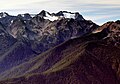
 Mt. Carrie (right), Ruth Peak (left) and Fairchild Glacier | |
| Highest point | |
| Elevation | 6,995 ft (2,132 m)[1] |
| Prominence | 1,675 ft (511 m)[1] |
| Isolation | 6.24 mi (10.04 km)[1] |
| Coordinates | 47°53′39″N 123°38′57″W / 47.894242°N 123.649295°W[1] |
| Geography | |
 Mount Carrie Location of Mount Carrie in Washington  Mount Carrie Mount Carrie (the United States) | |
| Location | Olympic National Park Clallam County, Washington, US |
| Parent range | Olympic Mountains Bailey Range |
| Topo map | USGS Mount Carrie |
| Geology | |
| Age of rock | Eocene |
| Type of rock | grey sandstone[2] |
| Climbing | |
| Easiest route | Scrambling YDS 2 via the High Divide Trail and Cat Walk[3] |
History edit
The Olympic Peninsula was largely unmapped until surveyors Arthur Dodwell and Theodore Rixon mapped most of its topography between 1898 and 1900, and what is now Mt. Carrie, was in 1899 one of the last remaining unnamed mountains in the Olympic range.[5] The mountain was named by Theodore Rixon for his wife Caroline "Carrie" (Jones) Rixon.[6] Carrie Rixon was a noted artist, painter, singer, and taught music to children. The Rixons lived at a 160-acre homestead she called Fairholme at the west end of Lake Crescent, until they moved to Teahwhit Head in 1916. Carrie died on May 20, 1946.[6]
Climate edit
Based on the Köppen climate classification, Mount Carrie is located in the marine west coast climate zone of western North America.[7] Most weather fronts originate in the Pacific Ocean, and travel northeast toward the Olympic Mountains. As fronts approach, they are forced upward by the peaks of the Olympic Range, causing them to drop their moisture in the form of rain or snowfall (Orographic lift). As a result, the Olympics experience high precipitation, especially during the winter months. During winter months, weather is usually cloudy, but, due to high pressure systems over the Pacific Ocean that intensify during summer months, there is often little or no cloud cover during the summer. In terms of favorable weather, the best months for viewing and climbing are July through September.
Gallery edit
-
 Mount Fairchild and Mt. Carrie seen from Hurricane Hill
 -
 Mount Carrie from north
 -
 Mount Fairchild (left) and Mt. Carrie seen from Hurricane Hill
 -
 Cat Peak, Mt. Fairchild, and Mt. Carrie seen from the west along High Divide


See also edit
References edit
- ^ a b c d e "Mount Carrie". Peakbagger.com.
- ^ National Park Service Geology of the Olympic Peninsula
- ^ a b climbersguideolympics.com Mount Carrie
- ^ "Mount Carrie". Geographic Names Information System. United States Geological Survey, United States Department of the Interior. Retrieved 2020-06-15.
- ^ Majors, Harry M. (1975). Exploring Washington. Van Winkle Publishing Co. p. 71. ISBN 978-0-918664-00-6.
- ^ a b Parratt, Smitty (1984). Gods and Goblins: A Field Guide to Place Names of Olympic National Park (1st ed.).
- ^ Peel, M. C.; Finlayson, B. L.; McMahon, T. A. (2007). "Updated world map of the Köppen−Geiger climate classification". Hydrol. Earth Syst. Sci. 11: 1633–1644. ISSN 1027-5606.
External links edit
- "Olympic National Park". National Park Service.
- Mount Carrie weather: Mountain Forecast
- Carrie Rixon photo: University of Washington digital library
- Mount Carrie aerial photo: PBase