


Summary
Mount Craig is a 12,007-foot-elevation (3,660-meter) mountain summit in Grand County, Colorado, United States.
| Mount Craig | |
|---|---|
 West aspect of Mt. Craig, center (East Inlet, foreground) | |
| Highest point | |
| Elevation | 12,007 ft (3,660 m)[1][2] |
| Prominence | 388 ft (118 m)[3] |
| Parent peak | Fleur De Lis (12,253 ft)[3] |
| Isolation | 1.21 mi (1.95 km)[3] |
| Coordinates | 40°13′09″N 105°43′42″W / 40.2191455°N 105.7283305°W[4] |
| Naming | |
| Etymology | Rev. William Bayard Craig |
| Geography | |
 Mount Craig Location in Colorado  Mount Craig Mount Craig (the United States) | |
| Country | United States |
| State | Colorado |
| County | Grand |
| Protected area | Rocky Mountain National Park |
| Parent range | Rocky Mountains Front Range |
| Topo map | USGS Isolation Peak |
| Geology | |
| Age of rock | Precambrian[6] |
| Type of rock | Granite of Longs Peak batholith[5] Biotite schist and gneiss[5] |
| Climbing | |
| Easiest route | class 2 hiking[3] |
Description edit
Mount Craig is set 3.5 miles (5.6 km) west of the Continental Divide in the Front Range of the Rocky Mountains. The mountain is situated within Rocky Mountain National Park and six miles (9.7 km) east of the town of Grand Lake, Colorado. Precipitation runoff from the mountain's slopes drains to Grand Lake via East Inlet. Topographic relief is significant as the summit rises 2,800 feet (850 meters) above East Inlet in one mile (1.6 km).
Etymology edit
The mountain is named after Reverend William Bayard Craig (1848–1916), the same person that the town of Craig, Colorado, is named for.[7] Rev. Craig owned lakeshore property at Grand Lake during the 1880s.[8] The mountain's toponym was officially adopted in 1932 by the United States Board on Geographic Names.[4]
Climate edit
According to the Köppen climate classification system, Mount Craig is located in an alpine subarctic climate zone with cold, snowy winters, and cool to warm summers.[9] Due to its altitude, it receives precipitation all year, as snow in winter and as thunderstorms in summer, with a dry period in late spring.
Gallery edit
-
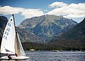 Mount Craig from Grand Lake
 -

-
 Mount Craig (Baldy) from East Inlet meadow


See also edit
- List of peaks in Rocky Mountain National Park
 Mountains portal
References edit
- ^ Robert M. Ormes (2000), Guide to the Colorado Mountains, Colorado Mountain Club Press, ISBN 9780967146607, p. 49.
- ^ "Mount Craig, Colorado". Peakbagger.com. Retrieved April 30, 2023.
- ^ a b c d "Craig, Mount - 12,025' CO". listsofjohn.com. Retrieved April 30, 2023.
- ^ a b "Mount Craig". Geographic Names Information System. United States Geological Survey, United States Department of the Interior. Retrieved April 30, 2023.
- ^ a b Geologic map of the Estes Park 30' x 60' quadrangle, north-central Colorado, W.A. Braddock, U.S. Geological Survey, 1984.
- ^ Lexicon of Geologic Names of the United States (including Alaska). Part 2 (1936), U.S. Government Printing Office, p. 2227.
- ^ William Bright, Colorado Place Names, 2004, Johnson Books, ISBN 9781555663339, page 45.
- ^ Suzanne Silverthorn (2015), Around Rocky Mountain National Park, Arcadia Publishing Incorporated, ISBN 9781439653036, p. 110.
- ^ Peel, M. C.; Finlayson, B. L.; McMahon, T. A. (2007). "Updated world map of the Köppen−Geiger climate classification". Hydrol. Earth Syst. Sci. 11. ISSN 1027-5606.
External links edit
- Weather forecast: Mount Craig
- William Bayard Craig (photo): Google.com/books