


Summary
Mount Dana is a mountain in the U.S. state of California. Its summit marks the eastern boundary of Yosemite National Park and the western boundary of the Ansel Adams Wilderness. At an elevation of 13,061 feet (3,981 m), it is the second highest mountain in Yosemite (after Mount Lyell), and the northernmost summit in the Sierra Nevada which is over 13,000 feet (3,962.4 m) in elevation. Mount Dana is the highest peak in Yosemite that is a simple hike to the summit. The mountain is named in honor of James Dwight Dana, who was a professor of natural history and geology at Yale.[6]
| Mount Dana | |
|---|---|
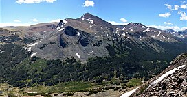 Mount Dana seen from Gaylor Peak. The hike to the top goes up this west face. | |
| Highest point | |
| Elevation | 13,061 ft (3,981 m) NAVD 88[1] |
| Prominence | 2,417 ft (737 m)[2] |
| Parent peak | Mount Lyell[3] |
| Listing | California highest major peaks 18th |
| Coordinates | 37°54′00″N 119°13′16″W / 37.899901553°N 119.2210926°W[1] |
| Geography | |
| Location | Mono / Tuolumne counties, California, U.S. |
| Parent range | Sierra Nevada |
| Topo map | USGS Mount Dana |
| Geology | |
| Age of rock | Cretaceous |
| Mountain type | Metamorphic rock |
| Climbing | |
| First ascent | June 28, 1863 by Whitney, Brewer, and Hoffmann[4] |
| Easiest route | Hike, class 1[5] |
Mount Dana is composed of prebatholithic rock that is mostly reddish metamorphic rock, which was composed by metavolcanics of surfacing magma from the Mesozoic Era.[7][8]
Mount Dana's northern face includes a small, receding glacier known as the Dana Glacier. The Dana Meadows lie at the foot of the mountain. From the top, lakes throughout Dana Meadows, Mono Lake, Tioga Peak and many other mountains are in view.
Hike edit
From the Tioga Pass Road there are many easy routes. (class 1), available that lead to the summit along the mountain's western or southern slopes. These routes rise 3,108 feet (947 m) in elevation in 2.9 miles (4.7 km), (a 20.3% average grade). The trail is not frequently maintained.

There is a clearly marked path leading just above tree line. After topping a ridge, a set of use-paths and ducked routes are present, with the main path running along the easterly ridgeline. Additionally, numerous alternate trail segments begin and end at various points on the southwestern face, making parts of this hike a difficult class 2. The path segments turn into scree toward the summit, where a shallow stone-walled shelter and register are found. Significant snow fields on the mountain slopes can exist late into the summer season. Total round trip hiking time can be anywhere between 3 and 12 hours depending many factors, such as acclimatization to elevation.
After reaching a plateau above the tree line, most vegetation disappears with the exception of lichen and a few high alpine plants such as Sky Pilot (Polemonium eximium). Fauna are largely limited to spiders and insects, such as black/brown grasshoppers. The only mammals other than humans are American Pikas (which are lagomorphs, related to rabbits) and marmots.
Thunderstorms are known to arise suddenly, making the rocks slippery, and the hiking dangerous year round.
Even experienced hikers can face altitude sickness, due to the high elevation.[9]
In the summer of 2009, an NPS employee died after falling on a technical rock climbing route on the northeast face of Mount Dana.[citation needed]
Climate edit
| Climate data for Mount Dana 37.9018 N, 119.2233 W, Elevation: 12,385 ft (3,775 m) (1991–2020 normals) | |||||||||||||
|---|---|---|---|---|---|---|---|---|---|---|---|---|---|
| Month | Jan | Feb | Mar | Apr | May | Jun | Jul | Aug | Sep | Oct | Nov | Dec | Year |
| Mean daily maximum °F (°C) | 28.5 (−1.9) |
26.9 (−2.8) |
29.4 (−1.4) |
33.6 (0.9) |
41.3 (5.2) |
51.2 (10.7) |
59.2 (15.1) |
58.5 (14.7) |
53.0 (11.7) |
44.2 (6.8) |
34.6 (1.4) |
28.5 (−1.9) |
40.7 (4.9) |
| Daily mean °F (°C) | 19.0 (−7.2) |
17.0 (−8.3) |
19.0 (−7.2) |
22.1 (−5.5) |
29.1 (−1.6) |
38.4 (3.6) |
45.6 (7.6) |
44.9 (7.2) |
39.6 (4.2) |
32.0 (0.0) |
24.6 (−4.1) |
19.2 (−7.1) |
29.2 (−1.5) |
| Mean daily minimum °F (°C) | 9.6 (−12.4) |
7.0 (−13.9) |
8.7 (−12.9) |
10.6 (−11.9) |
16.8 (−8.4) |
25.6 (−3.6) |
32.0 (0.0) |
31.2 (−0.4) |
26.3 (−3.2) |
19.9 (−6.7) |
14.5 (−9.7) |
10.0 (−12.2) |
17.7 (−7.9) |
| Average precipitation inches (mm) | 10.83 (275) |
9.58 (243) |
8.50 (216) |
4.66 (118) |
2.49 (63) |
0.62 (16) |
0.66 (17) |
0.53 (13) |
0.49 (12) |
2.72 (69) |
3.98 (101) |
9.32 (237) |
54.38 (1,380) |
| Source: PRISM Climate Group[10] | |||||||||||||
Gallery edit


References edit
- ^ a b "Mount Dana". NGS Data Sheet. National Geodetic Survey, National Oceanic and Atmospheric Administration, United States Department of Commerce.
- ^ "Mount Dana, California". Peakbagger.com. Retrieved 2009-08-05.
- ^ "Mount Dana". ListsOfJohn.com. Retrieved 2012-04-01.
- ^ Farquhar, Francis P. (March 1925). "Exploration of the Sierra Nevada". California Historical Society Quarterly. 4 (1): 3–58. doi:10.2307/25177743. hdl:2027/mdp.39015049981668. JSTOR 25177743.
- ^ Secor, R.J. (2009). The High Sierra Peaks, Passes, and Trails (3rd ed.). Seattle: The Mountaineers. pp. 397f. ISBN 978-0898869712.
- ^ Browning, Peter (1986). Place Names of the Sierra Nevada. Berkeley: Wilderness Press. p. 51. ISBN 0899971199.
- ^ "America's Volcanic Past - Yosemite National Park". USGS/Cascades Volcano Observatory. September 20, 2002. Archived from the original on May 16, 2006. Retrieved July 11, 2006.
- ^ "Biology 314 — Sierra Nevada". Sonoma State University. pp. 69–94. Retrieved 2006-07-08.
- ^ Cymerman, A; Rock, PB. "Medical Problems in High Mountain Environments. A Handbook for Medical Officers". USARIEM-TN94-2. US Army Research Inst. of Environmental Medicine Thermal and Mountain Medicine Division Technical Report. Archived from the original on 2009-04-23. Retrieved 2009-03-05.
{{cite journal}}: Cite journal requires|journal=(help)CS1 maint: unfit URL (link) - ^ "PRISM Climate Group, Oregon State University". PRISM Climate Group, Oregon State University. Retrieved October 6, 2023.
To find the table data on the PRISM website, start by clicking Coordinates (under Location); copy Latitude and Longitude figures from top of table; click Zoom to location; click Precipitation, Minimum temp, Mean temp, Maximum temp; click 30-year normals, 1991-2020; click 800m; click Retrieve Time Series button.
External links edit
- "Mount Dana". SummitPost.org.