


Summary
Mount Kokshe, also known as Kokshetau or Kokshe-Tau (Kazakh: Көкше-тау; pronounced [køkɕetɑw], Russian: Кокше-тау, гора́ Синю́ха, Gora Sinyukha, lit. 'blueish mountain') is a mountain in the Kokshetau Massif, Akmola Region, northern Kazakhstan.[2] It is the highest mountain in Akmola Region and the second highest mountain in the northern part of Kazakhstan.
| Mount Kokshe | |
|---|---|
| Kokshetau / Kokshe-Tau / Gora Sinyukha | |
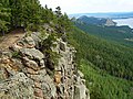
 Mount Kokshe as viewed from Bolektau | |
| Highest point | |
| Elevation | 947 m (3,107 ft)[1] |
| Prominence | 592 m (1,942 ft)[2] |
| Coordinates | 53°04′48″N 70°11′18″E / 53.08000°N 70.18833°E[1] |
| Naming | |
| Native name | |
| English translation | "Blueish mountain" |
| Pronunciation | Kazakh [køkɕetɑw] ⓘ |
| Geography | |
 Mount Kokshe Location in Northern Kazakhstan | |
| Country | Kazakhstan |
| Region | Akmola |
| District | Burabay |
| Parent range | Kokshetau Mountains Kokshetau Hills Kazakh Uplands |
The mountain is part of the Burabay National Park and is a popular destination, attracting tourists and climbers. It has several walking and scrambling routes leading to its summit and, as such, many walking guides recommend it to the occasional walker wishing to climb a mountain. The nearest city is Shchuchinsk, 25 km (16 mi) away.
Names and etymology edit
The mountain's official name in Kazakh is Kokshetau or Kokshe-Tau, Kokshe is derived from the common Kazakh word for "blueish", tau, meaning "mountain", thus kokshe + tau meaning "Blueish mountain"; its Russian name is Gora Sinyukha meaning the same. Both names hint at the bluish tint of the mountains when viewed from a distance.
Geography edit
With an elevation of 947 metres (3,107 ft) above sea level and a prominence of 592 m (1,942 ft), the peak is the highest point of the Kokshetau Massif, as well as the highest peak of the Kokshetau Hills.[1] It is located near lake Kishi Shabakty, west of Lake Burabay, dominating the skyline of the lake area.
Mount Kokshe has an absolute elevation of 947 m. It is situated in the Kazakh Uplands and is the second-highest mountain in the northern part of Kazakhstan, after Mount Akbet (at 1,022 metres (3,353 ft)) which is located in the Bayanaul Range, Pavlodar Region. The relief of the mountain area is spurry-ridgy with narrow rocky watersheds. The mountain slopes are covered with pine and pine-birch forests.[3]
See also edit
Image gallery edit
-
 View of Lake Ulken Shabakty and Lake Burabay from Sinyukha
 -
 Mount Kokshe (Gora Sinyukha) in August, 2019
 -
 Mount Kokshe (Gora Sinyukha) in August, 2019
 -
 USSR stamp: Borovoe, Kazakhstan. Series: Soviet Resort Towns


References edit
- ^ a b c "Burabay - Kazakh Wonderland". e-history.kz. Retrieved 2020-12-29.
- ^ a b "Gora Kokshetau (Sinyuha)". peakvisor.com. Retrieved 2020-12-29.
- ^ Akiyanova, F; Atalikhova, A; Jussupova, Z; Simbatova, A; Nazhbiev, A (2019). "Current state of ecosystems and their recreational use of the Burabay National Park (Northern Kazakhstan)". pp. 1231–1243.
External links edit
- Mount Kokshe is at coordinates 53°04′48″N 70°11′18″E / 53.08000°N 70.18833°E
- "Gora Sinyukha, Kazakhstan" on peakbagger