


Summary
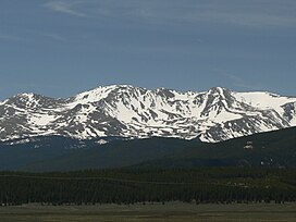
Mount Massive (Arapaho: Hiwoxuu hookuhu'ee) is the second-highest summit of the Rocky Mountains of North America and the U.S. state of Colorado. The prominent 14,428-foot (4,398 m) fourteener of the Sawatch Range is located in the Mount Massive Wilderness of San Isabel National Forest, 10.6 miles (17.1 km) west-southwest (bearing 247°) of the City of Leadville in Lake County, Colorado, United States. Mount Massive edges out the third-highest summit of the Rockies, Mount Harvard, by 7 feet (2.1 m), but falls short of Mount Elbert by 12 feet (3.7 m). It ranks as the third-highest peak in the contiguous United States after Mount Whitney and Mount Elbert.[a][1][3][2][5]
| Mount Massive | |
|---|---|
 | |
| Highest point | |
| Elevation | 14,428 ft (4398 m)[1] NAVD88 |
| Prominence | 1961 ft (598 m)[1] |
| Isolation | 5.06 mi (8.14 km)[1] |
| Listing | |
| Coordinates | 39°11′15″N 106°28′33″W / 39.1874645°N 106.4756995°W[2] |
| Geography | |
 Mount Massive | |
| Location | Lake County, Colorado, U.S.[3] |
| Parent range | Sawatch Range, Highest summit of the Massive Massif[1] |
| Topo map | USGS 7.5' topographic map Mount Massive, Colorado[2] |
| Climbing | |
| First ascent | 1873 by Henry Gannett |
| Easiest route | East Slopes: Hike, class 2[4] |
Mountain edit
Mount Massive was first surveyed and climbed in 1873 during the Hayden Survey of the American West. Survey member Henry Gannett is credited with the first ascent.[6] Its name comes from its elongated shape: it has five summits, all above 14,000 ft (4,300 m), and a summit ridge over 3 mi (4.8 km) long, resulting in more area above 14,000 ft (4,300 m) than any other mountain in the 48 contiguous states, narrowly edging Mount Rainier in that category. Mount Elbert (14,440 ft (4,400 m)) is Mount Massive's nearest neighbor among the fourteeners; it lies about 5 mi (8.0 km) south-southeast of the peak.[7]

A matter of some contention after the Great Depression arose over the heights of Massive and its neighbor, Mount Elbert, which have a height difference of only 12 feet (3.7 m). This led to an ongoing dispute which came to a head with the Mount Massive supporters taking it upon themselves to build large piles of stones on the summit to boost its height, only to have the Mount Elbert proponents demolish them.[8][9][10]
A class 2 hiking path leads to the peak from the eastern face. The path is 13.6 mi (21.9 km) round trip, with a 4,500 ft (1,400 m) elevation gain.[6]
There are several glacial lakes in the wilderness area. The lower slopes of the mountain are covered in lodgepole pine forests, which gradually yield to Engelmann Spruce and Fir. Treeline is just below 12,000 feet. Among the mountain's fauna are the American pika, the mountain goat, elk, mule deer, moose, Canada jay, martin, and the yellow-bellied marmot.
In the Arapaho Language the Collegiate Range and Mount Massive are called Hiwoxuu hookuhu'ee or Elk's Head.[5]
Climate edit
| Climate data for Mount Massive (CO) 39.1836 N, 106.4761 W, Elevation: 13,934 ft (4,247 m) (1991–2020 normals) | |||||||||||||
|---|---|---|---|---|---|---|---|---|---|---|---|---|---|
| Month | Jan | Feb | Mar | Apr | May | Jun | Jul | Aug | Sep | Oct | Nov | Dec | Year |
| Mean daily maximum °F (°C) | 19.7 (−6.8) |
18.8 (−7.3) |
24.0 (−4.4) |
30.3 (−0.9) |
39.1 (3.9) |
50.2 (10.1) |
56.5 (13.6) |
54.4 (12.4) |
47.9 (8.8) |
37.0 (2.8) |
26.0 (−3.3) |
19.8 (−6.8) |
35.3 (1.8) |
| Daily mean °F (°C) | 8.2 (−13.2) |
7.0 (−13.9) |
11.7 (−11.3) |
17.1 (−8.3) |
25.9 (−3.4) |
36.2 (2.3) |
42.4 (5.8) |
40.9 (4.9) |
34.6 (1.4) |
24.6 (−4.1) |
15.0 (−9.4) |
8.7 (−12.9) |
22.7 (−5.2) |
| Mean daily minimum °F (°C) | −3.3 (−19.6) |
−4.8 (−20.4) |
−0.6 (−18.1) |
3.9 (−15.6) |
12.7 (−10.7) |
22.2 (−5.4) |
28.3 (−2.1) |
27.4 (−2.6) |
21.3 (−5.9) |
12.1 (−11.1) |
4.1 (−15.5) |
−2.4 (−19.1) |
10.1 (−12.2) |
| Average precipitation inches (mm) | 4.76 (121) |
4.48 (114) |
4.73 (120) |
5.80 (147) |
4.46 (113) |
1.78 (45) |
2.05 (52) |
2.21 (56) |
3.00 (76) |
3.80 (97) |
4.71 (120) |
4.08 (104) |
45.86 (1,165) |
| Source: PRISM Climate Group[11] | |||||||||||||
See also edit
Notes edit
References edit
- ^ a b c d e "Mount Massive, Colorado". Peakbagger.com. Retrieved December 30, 2015.
- ^ a b c "Mount Massive". NGS Data Sheet. National Geodetic Survey, National Oceanic and Atmospheric Administration, United States Department of Commerce. Retrieved October 21, 2014.
- ^ a b "Mount Massive". Geographic Names Information System. United States Geological Survey, United States Department of the Interior. Retrieved October 29, 2014.
- ^ "Mt. Massive Routes". 14ers.com.
- ^ a b "Colorado Places: Their Native American Names". Center for Native American and Indigenous Studies (CNAIS). 2020-07-24. Retrieved 2024-01-12.
- ^ a b "Mount Massive". Summitpost. Retrieved August 22, 2012.
- ^ "Mount Massive". hikingincolorado.org. August 28, 1999. Retrieved July 17, 2009.
- ^ Dziezynski, James. Best Summit Hikes in Colorado. Wilderness Press. p. 157.
- ^ Stewart Green, Fast Facts About Mount Elbert
- ^ KEN JENNINGS, the Tallest Mountains in the U.S. Are Almost the Same Height
- ^ "PRISM Climate Group, Oregon State University". PRISM Climate Group, Oregon State University. Retrieved October 9, 2023.
To find the table data on the PRISM website, start by clicking Coordinates (under Location); copy Latitude and Longitude figures from top of table; click Zoom to location; click Precipitation, Minimum temp, Mean temp, Maximum temp; click 30-year normals, 1991-2020; click 800m; click Retrieve Time Series button.
External links edit
 Definitions from Wiktionary
 Media from Commons
 News from Wikinews
 Quotations from Wikiquote
 Texts from Wikisource
 Textbooks from Wikibooks
 Resources from Wikiversity
- "Mount Massive". 14ers.com.