


Summary
Mount Merbabu (Indonesian: Gunung Merbabu) is a dormant stratovolcano in Central Java province on the Indonesian island of Java. The name Merbabu could be loosely translated as 'Mountain of Ash' from the Javanese combined words; Meru means "mountain" and awu or abu means "ash".
| Mount Merbabu | |
|---|---|
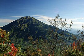 Mt Merbabu viewed from Mount Merapi | |
| Highest point | |
| Elevation | 3,145 m (10,318 ft)[1] |
| Prominence | 2,432 m (7,979 ft)[1] |
| Listing | Ultra Ribu |
| Coordinates | 07°27′18″S 110°26′24″E / 7.45500°S 110.44000°E[1] |
| Naming | |
| English translation | Mountain of ash |
| Language of name | Indonesian |
| Geography | |
| Parent range | Sunda Arc |
| Geology | |
| Age of rock | 700.000 Years |
| Mountain type | Dormant stratovolcano |
| Last eruption | 1797 |
| Climbing | |
| Easiest route | Hike starting near Kopeng |


The active volcano Mount Merapi is directly adjacent on its southeast side, while the city of Salatiga is located on its northern foothills. A 1,500m high broad saddle lies between Merbabu and Merapi,[2] the site of the village of Selo, Java, and highly fertile[3][4] farming land.
There are two peaks; Syarif (3,119 m) and Kenteng Songo (3,145 m). Three U-shaped radial valleys extend from the Kenteng Songo summit in northwesterly, northeasterly, and southeasterly directions.

Two known moderate eruptions occurred in 1560 and 1797. The 1797 event was rated 2: Explosive, on the Volcanic Explosivity Index.[5] An unconfirmed eruption may have occurred in 1570.[6]
Geologically recent eruptions originated from a North Northwest-South Southeast fissure system that cut across the summit and fed the large-volume lava flows from Kopeng and Kajor craters on the northern and southern flanks, respectively.[2]
Merbabu can be climbed from several routes originating from the town of Kopeng on the northeast side, and also from Selo on the southern side. A climb from Kopeng to Kenteng Songo takes between 8 and 10 hours.[citation needed]
An area of 57 square kilometres (22 sq mi) at the mountain has been declared a national park in 2004.[7]
See also edit
References edit
- ^ a b c "Mountains of the Indonesian Archipelago" Peaklist.org. Retrieved 2012-06-23.
- ^ a b "Merbabu: General Information". Global Volcanism Program. Smithsonian Institution. Retrieved 2021-06-24.
- ^ Troll, Valentin R.; Deegan, Frances M.; Jolis, Ester M.; Budd, David A.; Dahren, Börje; Schwarzkopf, Lothar M. (2015-03-01). "Ancient oral tradition describes volcano–earthquake interaction at merapi volcano, indonesia". Geografiska Annaler: Series A, Physical Geography. 97 (1): 137–166. doi:10.1111/geoa.12099. ISSN 0435-3676. S2CID 129186824.
- ^ Wilson, T (2007). "Impacts of the 2006 eruption of Merapi volcano, Indonesia, on agriculture and infrastructure". GNS Science Report. 07: 69p.
- ^ "Merbabu: Eruptive History". Global Volcanism Program. Smithsonian Institution. Retrieved 2021-06-24.
- ^ Simkin, T., and Siebert, L., 1994, Volcanoes of the World: Geoscience Press, Tucson, Arizona, 349 p.
- ^ Lestari Hutan Indonesia Archived 2010-04-20 at the Wayback Machine. Retrieved 26 February 2010.
External links edit
- Centre of Volcanology & Geological Hazard Mitigation, Pusat Vulkanologi & Mitigasi Bencana Geologi, Volcanological Survey of Indonesia.