


Summary
Mount Ouray is a high and prominent mountain summit in the far southern Sawatch Range of the Rocky Mountains of North America. The 13,961-foot (4255.4 m) thirteener is located in San Isabel National Forest, 7.5 miles (12.0 km) west (bearing 270°) of Poncha Pass, Colorado, United States, on the boundary between Chaffee and Saguache counties. The mountain was named in honor of Ute Chief Ouray.[1][2][3]
| Mount Ouray | |
|---|---|
 East aspect | |
| Highest point | |
| Elevation | 13,961 ft (4255.4 m)[1] NAVD88 |
| Prominence | 2659 ft (810 m)[2] |
| Isolation | 13.58 mi (21.9 km)[2] |
| Listing | |
| Coordinates | 38°25′22″N 106°13′29″W / 38.4227178°N 106.2247474°W[1] |
| Geography | |
 Mount Ouray | |
| Location | Chaffee and Saguache counties, Colorado, United States[3] |
| Parent range | Sawatch Mountains[2] |
| Topo map | USGS 7.5' topographic map Mount Ouray, Colorado[1] |
| Climbing | |
| Easiest route | West ridge, class 2 |
Mountain edit
Mount Ouray makes up the southern tip of Sawatch Mountains, rising 7,000 feet above the Arkansas River Valley. Monarch Pass is four miles northwest of the peak.
The mountain is named after the Ute Chief Ouray. Nearby Chipeta Mountain, just over a mile to the northwest of Mount Ouray, is named after Chief Ouray's wife.
Routes edit
The standard route is the west ridge. Starting at Marshall Pass, the route heads north along the Continental Divide until the west ridge of Mount Ouray is reached. From there, one can hike east along this ridge up to the summit.
Climate edit
According to the Köppen climate classification system, Mount Ouray is located in an alpine subarctic climate zone with long, cold, snowy winters, and cool to warm summers.[4] Due to its altitude, it receives precipitation all year, as snow in winter and as thunderstorms in summer, with a dry period in late spring.
| Climate data for Mount Ouray 38.4227 N, 106.2250 W, Elevation: 13,337 ft (4,065 m) (1991–2020 normals) | |||||||||||||
|---|---|---|---|---|---|---|---|---|---|---|---|---|---|
| Month | Jan | Feb | Mar | Apr | May | Jun | Jul | Aug | Sep | Oct | Nov | Dec | Year |
| Mean daily maximum °F (°C) | 23.2 (−4.9) |
23.1 (−4.9) |
28.4 (−2.0) |
33.8 (1.0) |
42.4 (5.8) |
54.3 (12.4) |
59.4 (15.2) |
57.0 (13.9) |
50.9 (10.5) |
40.8 (4.9) |
30.3 (−0.9) |
23.6 (−4.7) |
38.9 (3.9) |
| Daily mean °F (°C) | 11.9 (−11.2) |
11.4 (−11.4) |
16.1 (−8.8) |
21.0 (−6.1) |
29.7 (−1.3) |
40.3 (4.6) |
45.5 (7.5) |
43.9 (6.6) |
38.0 (3.3) |
28.6 (−1.9) |
19.3 (−7.1) |
12.5 (−10.8) |
26.5 (−3.0) |
| Mean daily minimum °F (°C) | 0.6 (−17.4) |
−0.2 (−17.9) |
3.7 (−15.7) |
8.3 (−13.2) |
17.0 (−8.3) |
26.3 (−3.2) |
31.7 (−0.2) |
30.8 (−0.7) |
25.0 (−3.9) |
16.3 (−8.7) |
8.2 (−13.2) |
1.5 (−16.9) |
14.1 (−9.9) |
| Average precipitation inches (mm) | 2.70 (69) |
2.75 (70) |
2.90 (74) |
3.39 (86) |
2.48 (63) |
1.19 (30) |
2.51 (64) |
2.84 (72) |
2.26 (57) |
1.99 (51) |
2.43 (62) |
2.48 (63) |
29.92 (761) |
| Source: PRISM Climate Group[5] | |||||||||||||
Gallery edit
-
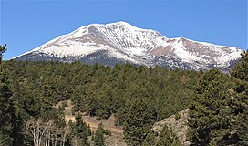
 Mt. Ouray centered on skyline
 -
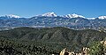
 Mount Ouray above Marshall Pass in 1899.
 -
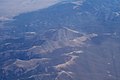 Aerial photo of Mount Ouray in 2020


Historical names edit
- Hump Mountain
- Mount Ouray – 1962 [3]
- Ouray Mountain
- Ouray Peak – 1906 [3] (there is a different Ouray Peak in northern Chaffee County)
See also edit
References edit
- ^ a b c d "MOUNT OURAY RESET". NGS Data Sheet. National Geodetic Survey, National Oceanic and Atmospheric Administration, United States Department of Commerce. Retrieved January 8, 2016.
- ^ a b c d "Mount Ouray, Colorado". Peakbagger.com. Retrieved January 8, 2016.
- ^ a b c d "Mount Ouray". Geographic Names Information System. United States Geological Survey, United States Department of the Interior. Retrieved October 29, 2014.
- ^ Peel, M. C.; Finlayson, B. L.; McMahon, T. A. (2007). "Updated world map of the Köppen−Geiger climate classification". Hydrol. Earth Syst. Sci. 11. ISSN 1027-5606.
- ^ "PRISM Climate Group, Oregon State University". PRISM Climate Group, Oregon State University. Retrieved October 10, 2023.
To find the table data on the PRISM website, start by clicking Coordinates (under Location); copy Latitude and Longitude figures from top of table; click Zoom to location; click Precipitation, Minimum temp, Mean temp, Maximum temp; click 30-year normals, 1991-2020; click 800m; click Retrieve Time Series button.
External links edit
 Definitions from Wiktionary
 Media from Commons
 News from Wikinews
 Quotations from Wikiquote
 Texts from Wikisource
 Textbooks from Wikibooks
 Resources from Wikiversity