


Summary
Mount Quincan is a volcanic mountain near Yungaburra on the Atherton Tableland in Far North Queensland, Australia.
| Mount Quincan | |
|---|---|
| Highest point | |
| Coordinates | 17°18′11″S 145°34′39″E / 17.30306°S 145.57750°E |
| Geography | |
| Location | Queensland, Australia |
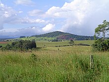
The extinct volcano is one of many cinder cones in the Atherton Tableland region.[1] Its crater is approximately 500 m across, with the main cone being to the northwest. Several of the nearby Seven Sisters cinder cones also have their craters to the southeast, which is possibly due to the ash and scoria being blown to the northwest by the prevailing SE winds.[2] Swamp deposits within the crater were dated at 7250 years old, making that the minimum age for Mt Quincan.[3] The scoria deposits also contain abundant mantle xenoliths of peridotite.[4]

Quincan, a type of Scoria, is mined from the south west quadrant of the mountain.[5] Quincan is used in road construction, driveways, weed control and domestic gardening.
References edit
- ^ Johnson, Robert Wallace (1989). Intraplate Volcanism: In Eastern Australia and New Zealand. Cambridge University Press. p. 92. ISBN 978-0521380836. Retrieved 21 November 2012.
- ^ Lottermoser, B. G.; Whitehead, P. W.; Nelson, P. N.; Beaman, R. J. (2008). Rocks, Landscapes and Resources of the Wet Tropics. Brisbane: Geological Society of Australia, Queensland Division. p. 17. ISBN 9780975789483.
- ^ KERSHAW, A. P. (1971). "A POLLEN DIAGRAM FROM QUINCAN CRATER, NORTH-EAST QUEENSLAND, AUSTRALIA". New Phytologist. 70 (4): 669–681. doi:10.1111/j.1469-8137.1971.tb02567.x. ISSN 0028-646X.
- ^ Whitehead, P. W.; Stephenson, P. J.; McDougall, I.; Hopkins, M. S.; Graham, A. W.; Collerson, K. D.; Johnson, D. P. (2007). "Temporal development of the Atherton Basalt Province, north Queensland". Australian Journal of Earth Sciences. 54 (5): 691–709. doi:10.1080/08120090701305236. ISSN 0812-0099.
- ^ Yungaburra Quarry. Retrieved on 21 November 2012.
External links edit